Geospatial Applications in Forest Resource Assessment of Nepal


 tiles")

 covering Nepal")

")
 return from ground 1 st return from tree top 2")


- Slides: 15
Geospatial Applications in Forest Resource Assessment of Nepal Prakash Mathema Director General Department of Forest Research and Survey Government of Nepal India Geospatial Forum Hyderabad, India 11 February 2015
Brief overview of FRA of Nepal § 2010 -2014 § Implemented by DFRS with Support from Finnish Government Salient Features § Comprehensive forest resource data generation: forest stock, spatial coverage, soil characteristics and biodiversity § Every sample plot is a permanent plot § Protected area also included in sample sites (unlike previous NFIs) § Focus on open source programmes and tools § Improved forest resources information sharing mechanism (OSFIS Component – Open Source Forest Information System). § Use of geospatial methods for aiding forest resource assessment
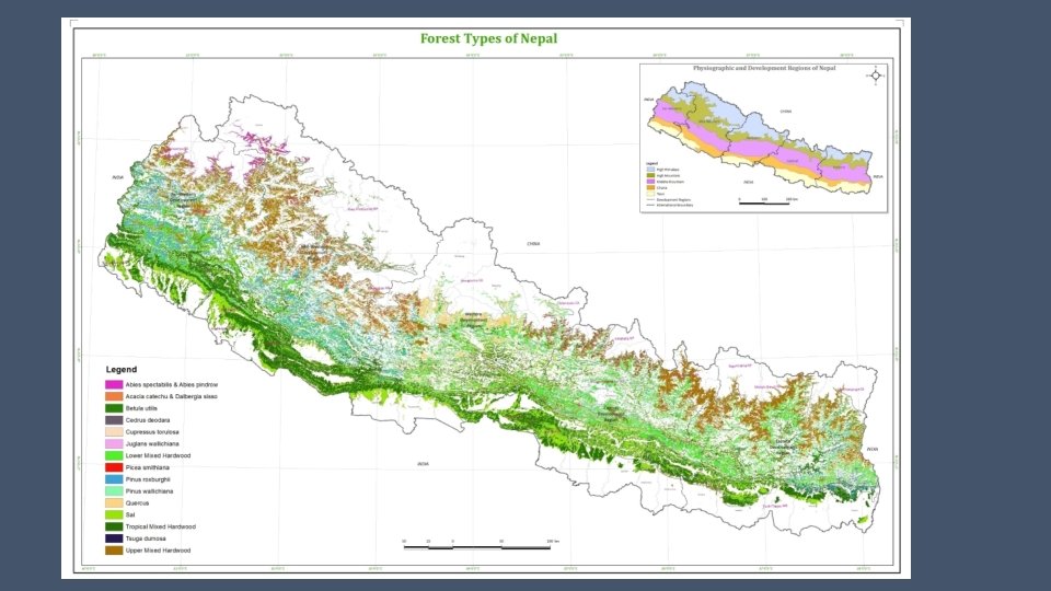
Major Applications § Navigation to plot for tree measurement and soil sample collection (Latest Rapid. Eye satellite image (5 m spatial resolution) map used together with GPS for navigating to sample plots) § Wall-to-wall forest cover mapping done using hybrid approach (object based image segmentation, machine learning classification and validation of polygons with human interpretation) § Forest type classification (Landsat image 2013/14, image segmentation and Classification and Regression Tree (CART) approach used, validation sample from measured field plot datasets across Nepal) § Piloting of Li. DAR assisted forest biomass assessment for part of Western Nepal Terai
Navigation to sample plot Location of sample plots across Nepal Sample plot layout Navigation and plot measurement
Wall-to-wall forest cover mapping Rapid. Eye (2010/11) tiles
Wall-to-wall Forest Cover Map
Forest type classification Landsat 8 Scenes (2013/14) covering Nepal
Li. DAR: Quantifying the forest carbon with laser scanning Terai Arc Landscape Districts
Blocks covering 5 % of the study area (Li. DAR scanned sample)
1 st (and only) return from ground 1 st return from tree top 2 nd return from branches 3 rd return from ground Field Plot Airborne Laser scanning Scanning equipment Field data collection Field data against the simulated Li. DAR estimates
Key future activities § Wall-to-wall National Land Cover Data using LANDSAT 8 and supplementary images aligned with country’s REDD+MRV mechanism every two years from 2016 § Biomass model development in selected Verification Sites using very high resolution optical imageries with support of radar imageries § 3 sites in 2015 and 4 sites in 2016 § Monitoring of rapid deforestations and degradation sites using LANDSAT 8 and VHR images (e. g. CARTOSAT)
Required data types § Wall-to-wall Optical mid resolution, e. g. LANDSAT 8 § Wall-to-wall radar data for southern Terai and Churia physiographic regions § VHR e. g. CARTOSAT/World View/Geoeye imageries for verification sites /degradation study sites/deforestation hotspots
Areas needing collaboration § Wall-to-wall biomass modelling and estimation of forest carbon § Assessment and mapping of forest degradation using Optical and SAR data or any other proven methodology § Study on regional scale forest ecosystem modelling § Capacity building
Thanks for your attention