Georgia Studies PreTest 1 Take PreTest 2 Grade


 changed over time")


- Slides: 63
Georgia Studies Pre-Test 1. Take Pre-Test 2. Grade your own Pre-Test Answer sheets are located on the front table 3. Answer the question at the bottom of your answer sheet 4. Turn in under TV 5. Wait for everyone to finish so we can talk about the field trip!
5 Regions of Georgia Due Tuesday at the end of class
Geography
Geography: the science of studying earth as the home of humans.
Geography Identify: This allows us to understand ourselves, the places that we live, our relationships with the environment and our interdependence on other areas of the world.
Geography Cars: Route 66
Geography Relative Location: Describes where a place is compared with other places So what is Georgia’s relative location?
Geography Why is relative location important? Describes weather patterns, gives us a general location and allows us to look at the big picture
Geography Absolute Location: Identifies a precise position on Earth’s surface’ often stated in longitude and latitude What is Georgia’s absolute location?
Geography Hemispheres: One half of a sphere Which hemisphere is Georgia located in?
Geography
Geography North Western
Geography Parallels: An imaginary line that runs east and west side-by-side with the equator Latitude: A measure of the distance north or south of the equator; expressed in degrees, minutes & seconds
Geography
Geography Meridians: A line that runs north and south from one pole to the other Longitude: A measure of the distance east or west of the prime meridian; expressed in degrees, minutes, and seconds
Geography Region: An area of Earth’s surface that is defined by certain unifying characteristics
Geography Barrier Island: An island that lies off the coast and protects the beaches by blocking much of the wind, sands, and water that could erode the mainland
Georgia’s Climate
Climate v. Weather Climate refers to the type of weather a region experiences over a long period of time. Weather refers to the day-to-day conditions and changes in the atmosphere
Temperature Georgia’s temperature is mild compared to other states Northern Georgia climate is slightly different because of its mountainous features.
Vertical climate: is when temperatures are lower because of the higher elevation
Precipitation Average rainfall in Georgia: • 40 -52 in. in central & south GA • 65 -76 in. in the mountains • Wettest month = July • Driest month = October
Precipitation Blue Ridge Mountains provide precipitation for the whole state by preventing humidity to cross over them
Drought Combined with the rain that we already receive, the snow from the north Georgia mountains melts and runs off into our rivers and lakes providing water for our crops. When we have a shortage of rainfall, Georgia’s economy is dramatically effected. Not only are we in danger of loosing our crops, but water related recreational activities also become more difficult.
Do you have any questions about Georgia’s Climate?
Questions 1. How does Georgia’s latitude and longitude affect our climate? 2. Why is precipitation so important to Georgia’s economy? 3. How does the Gulf of Mexico affect Georgia’s climate?
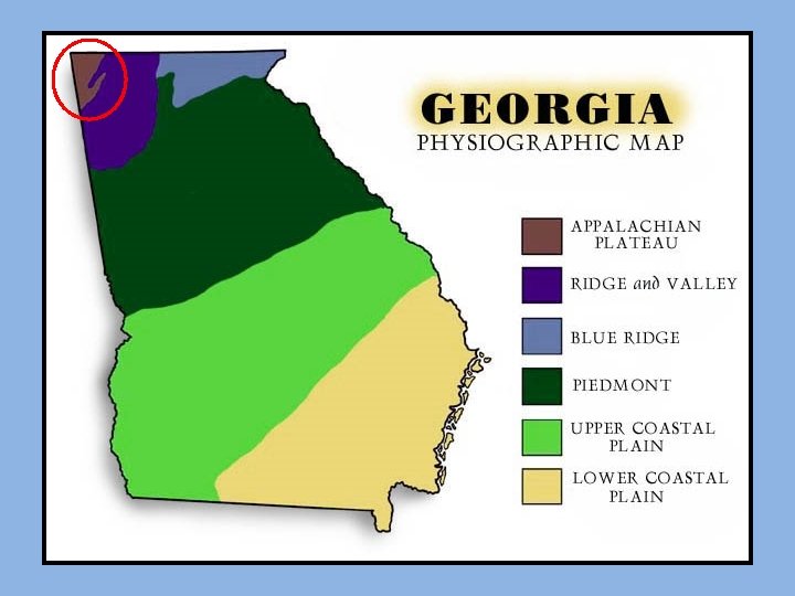
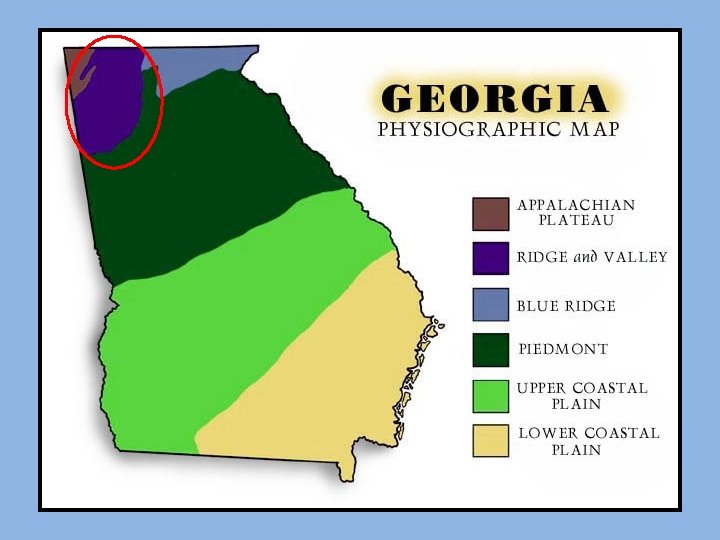
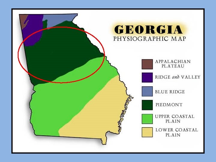
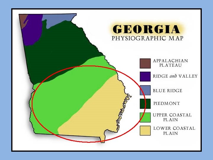
The Five Regions of Georgia
Appalachian Plateau • Limestone caves & canyons • Nicknames: • “TAG” Corner: Tennessee, Alabama & Georgia • Cumberland Plateau • Lookout & Sand Mountain • Soil composition: • limestone, shale & sandstone • Hardwood Forests • Battle of Chickamauga
Ridge & Valley • Made up of ridges & valleys • Soil Composition: • Shale & limestone • Resistant to erosion • Mostly forests & pastures • Taylor Ridge & Pigeon Mountain • Dalton, GA: “the carpet capitol of the world!”
Blue Ridge Region • Provides precipitation for the entire state • Sandy Loam soil: mixture of clay, sand & organic matter • Brasstown Bald: 5, 000 feet • Springer Mountain: beginning of Appalachian Trail • Amicolola Falls • Tallulah Gorge • Helen
Piedmont • “foot of the mountain” • Made of rolling hills and flat plains • Granite, Sandy Loam & GA red clay • ½ population
Fall Line This is an imaginary line that separates the Piedmont from the Coastal Plain Columbus Macon Augusta Fuller’s Earth is mined along the Fall Line, which is the mineral used in Kitty Litter
Coastal Plain • 3/5 State • Inner Coastal: mild climate with good supply of underground water • Outer Coastal: wetlands & barrier islands
Marble
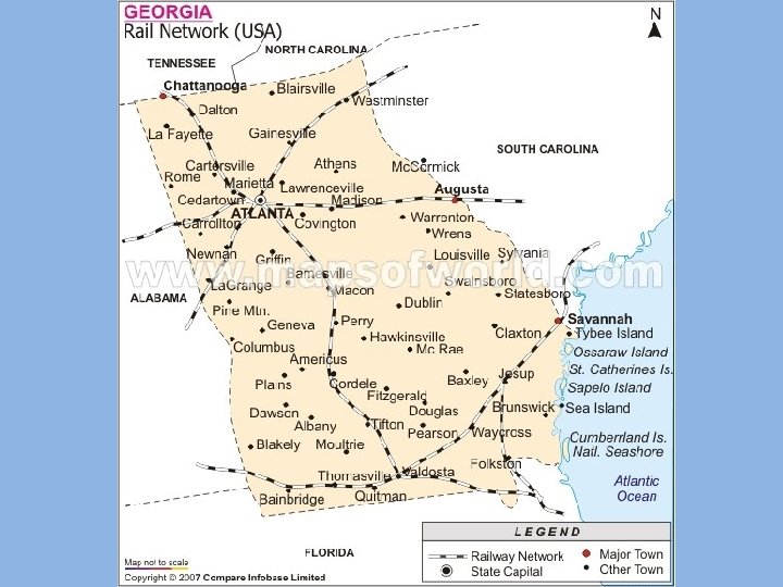
Georgia's Transportation Systems
Essential Question How have Georgia’s transportation systems (air, land, water, railroads) changed over time and affected human activity and economic opportunities?
WATER
Georgia’s waterways provided transportation and food for early Indian tribes. When European settlers arrived, they set up trading posts and established temporary and permanent settlement sites on river bluffs (steep riverbanks).
Why would early people chose to live near water?
For about 100 years after its founding, Georgia generally used transportation routes first established by Native Americans.
Why?
Atlantic Ocean • Georgia has more than 100 miles of coastline • Begins at the Savannah River and goes to the St. Mary’s River
Georgia’s waterways serve as important inland “highways” for social, political, and economic growth.
Why?
DEEPWATER PORTS Savannah & Brunswick
LAND
Georgia Highways Odd Even
From Georgia, goods are two truckload days from 82 % of the United States industrial marketplace and 79 % of the nation’s largest consumer markets.
• Over 100 motor freight carriers serve the metropolitan areas of Georgia. • The state has 35 scheduled carriers, 2, 200 intrastate haulers, and 25, 000 interstate truckers serving the state.
RAILROADS
Georgia’s two major railroad lines: 1. CSX 2. Norfolk Southern
AIR
• In 1926, the first air mail service in the region began from Chandler Field. • In 1929, Delta Air Lines began passenger service between Atlanta and Dallas. • In 1930, Eastern Air Lines began serving Atlanta.
• the city of Atlanta bought Candler Field in 1930 and began building hangers and lengthening runways. The rest is history. . .
Hartsfield-Jackson Atlanta International Airport, named former Atlanta mayors William B. Hartsfield and Maynard Jackson, has a main terminal, six concourses, and nearly 200 gates.
Hartsfield-Jackson Atlanta International Airport • one of the busiest passenger airports in the world. • In an average weekday afternoon, 500 aircraft may be in the air flying toward Hartsfield-Jackson, and an equal number may be in the air after departing it. • In an average month, about 80, 000 flights and more than 7 million passengers pass through the airport on flights scheduled with 21 airlines. • At the same time, the airport will handle about 53, 700 metric tons of cargo and more than 60, 000 metric tons of mail on airliners and cargo aircraft operated by 20 companies.