Geography Vocabulary pg 3 Copy the following definitions

Geography
 Geography- the study of the Earth,")
Vocabulary pg 3 Copy the following definitions: 1) Geography- the study of the Earth, people, places and environments. 2) Map Legend- gives symbols to represent places on a map 3) Map Scale- compares distance on a map to actual distance on the Earth. 4) Political Map- a map that shows human-made features and boundaries such as cities, highways and countries. 5) Physical Map- a map that shows naturally occurring physical features of the Earth. 6) Continent- one of seven major land masses of the Earth’s surface. 7) Absolute location- description of a place using grid coordinates (latitude and longitude) 8) Relative location- description of a place using the relation of one place to another 9) Compass rose-a directional arrow that shows cardinal and sometimes intermediate directions on a map 10) Immigrant- a person who leaves one area to settle in another 11) Migrate- to move from one geographic region to another 12) Pull factor- a reason that would attract someone to move to another place 13) Push factor- a reason that would make someone want to leave their place and go somewhere else

Geography

Globes and Maps

Globes are three dimensional representations of the earth

Advantages of Globes are more accurate than maps, better representation of the Earth. Globes are not distorted

Disadvantages of Globes are not portable Globes do not show detail Globes are more expensive than maps There are no thematic globes

Maps are two dimensional representations of the earth
")
Advantages of Maps are cheaper than globes show detail can show themes (thematic maps) and be used for comparing things Maps can be put into a book called an atlas Maps are portable

Disadvantages of Maps are distorted because the earth is not flat Maps can distort shape, area, direction, and distance This problem is somewhat solved by different map projections

Map Projections Map projections are a way to draw maps in order to lessen distortion. There are different types of projections because people use maps for different reasons.

Different Types of Maps Political Maps Physical Maps Topographic Maps Thematic Maps Cartograms

Political Maps Political maps show man-made features such as cities, states, provinces, territories, or countries

Physical Maps Physical maps help you see the type of landforms and bodies of water in a specific area
 comparing and contrasting maps")
Maps vs. Globes Assignment Write a short (2 -3 paragraphs) comparing and contrasting maps and globes. Use your notes from yesterday to help you. Remember: This is not Instagram or tumblr, use proper English and grammar. Item #6

Map Skills How do we find places on maps?

Vocabulary Term Compass Is a tool that helps the user know what direction they are going.

Directions on a Compass Cardinal directions North, South, East, West Intermediate Northeast, directions Southeast, Southwest, Northwest

Imaginary Lines Latitude and Longitude The earth is divided into lots of lines called latitude and longitude

Lines Longitude and south. Latitude and west. The lines run north lines run east lines measure distances in degrees.

Latitude Lines run horizontally Measures distance North or South from the Equator. The Equator is 0 degrees Latitude.

Where is 0 degree? equator Is 0 degree latitude. imaginary belt that runs halfway point between the North Pole and the South Pole.

Latitude North Pole 90 Lines of North latitude are numbered from 0° to 90° are N. L. [ 80 70 60 50 40 30 20 10 ] 10 20 30 40 50 60 70 80 South Pole 90 Lines of South latitude are numbered from 0° 90° are S. L.

Latitude The North Pole is at 90° N The equator is at 0° latitude. It is neither north nor south. It is at the The South Pole center is at 90° S between north and south. 40° N is the 40° line of latitude north of the equator. 40° S is the 40° line of latitude south of the equator.

Major lines of latitude North Pole Arctic Circle Tropic of Cancer Equator Tropic of Capricorn Antarctic South Circle Pole

Longitude Lines of Longitude run vertically. They are also called Meridians locate places East or West of the Prime Meridian. There are 180 degrees of east Longitude, and 180 degrees of west Longitude. The Prime Meridian is found in Greenwich, England is 0 degrees Longitude.

Longitude Lines run vertically Longitude lines are called Meridians The main Meridian is called the PRIME MERIDIAN

Longitude Lines of longitude begin at the Prime Meridian. 60° W is the 60° line of longitude west of the Prime. W Meridian. 60° E is the 60° line of longitude E east of the Prime Meridian. The Prime Meridian is located at 0°. It is neither east or west

180° East Longitude West Longitude North Pole Longitude N W PRIME MERIDIAN E S Lines of longitude are numbered east from the Prime Meridian to the 180° line and west from the Prime Meridian to the 180° line.

Longitude and latitude rap grid coordinates

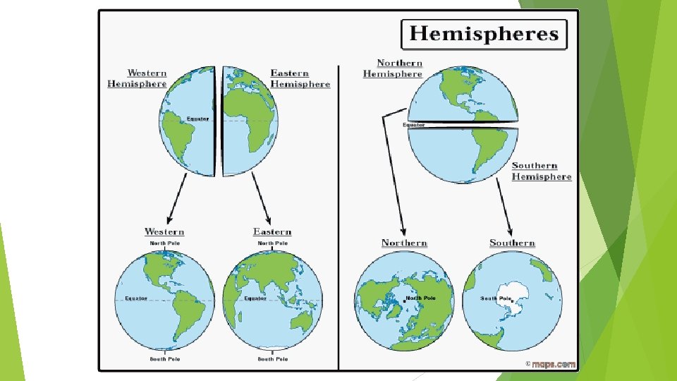
Hemispheres The Equator splits the earth into the northern and southern hemisphere The Prime Meridian splits the earth into Eastern and Western hemisphere

Map Legends/Key Objects or colors in the legend represent something on the map. Religions Legend

Can you understand this legend?

Age Expectancy Legend

“How To” Foldable Step #1: Highlight the Equator YELLOW and Prime Meridian PINK N Step #2: Draw the Compass Rose in the bottom corner * North, South, East, West, Northeast, Southeast, Northwest, Southwest Step #3: Using the lines made by the highlighted equator and Prime Meridian to label the cardinal directions on the globe. NW NE E W Step #4: Label the Hemispheres using the intermediate directions on the inside of the quadrant in the globe. SW SE S

GLOBE SAYS This game follows the same rules as “Simon Says” Body parts represent the major lines of latitude Top of head – North Pole Ears – Arctic Circle Shoulders – Tropic of Cancer Waist – Equator Knees – Tropic of Capricorn Shins – Antarctic Circle Toes – South Pole

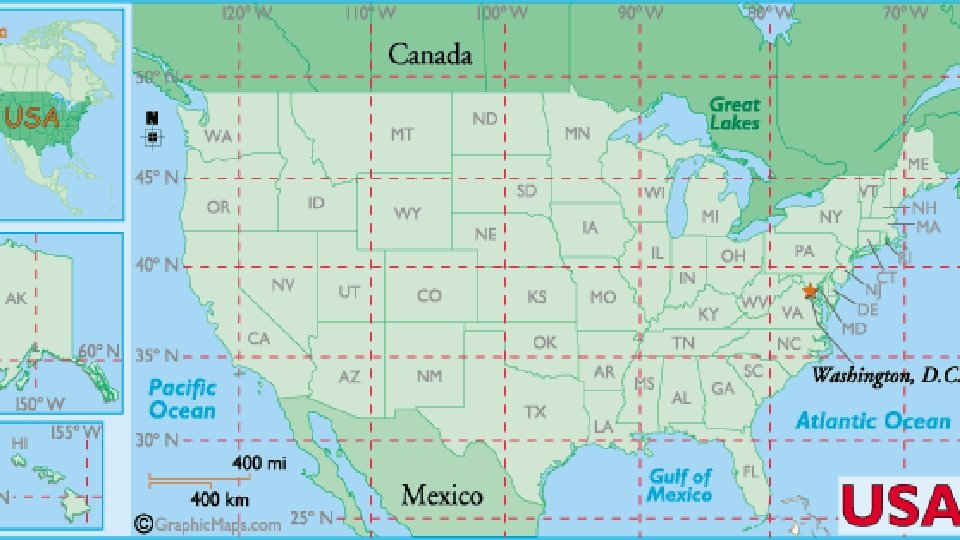
Longitude and Latitude Practice Use pp. A 16 and A 17 in your green textbook. Copy each coordinate and then find it on the map/atlas. Find the city or island located at each of the following coordinates; write the name of the city or island on the first line. Also, tell the hemisphere of each location; write the hemisphere on the second line. 1. 39°S, 140°E _______________, ________ 2. 33°N, 120°W _______________, ________ 3. 20°N, 73°E ________________, ________ 4. 57°N, 41°E________________, ________ 5. 15°S, 48°E________________, ________ 6. 38°N, 140°E________________, ________ 7. 14°N, 100°E________________, ________ 8. 18°N, 101°W_______________, ________ 9. 0°longitude, 50°N_____________, ________ 10. 21°S, 44°W________________, ________

Map skills review packet Complete the packet for map skills. This will be homework if not completed and we will grade on Thursday

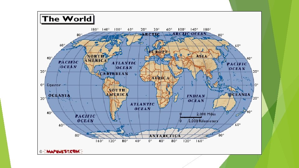
Continents? What are the seven continents? Five oceans? Why do we need to know the seven continents? Tour the World Learn the Seven Continents

THE 5 THEMES OF GEOGRAPHY CH 1 SECTION 1 NOTES

Five Themes of Geography Theme and description Movement Regions Human-Environment Interactions Location Place - Examples and Key words

MOVEMENT How are people, goods, ideas moved from place to place? Human Movement Trucks, Trains, Planes Information Movement Phones, computer (email), mail Idea Movement How do fads move from place to place? TV, Radio, Magazines

REGIONS How are Regions similar to and different from other places? How places are grouped? Formal Regions defined by governmental or administrative boundaries (States, Countries, Cities) Regions defined by similar characteristics (Corn Belt, Rocky Mountain region, Chinatown). Functional Regions defined by a function (newspaper service area, cell phone coverage area). Vernacular Regions (Not in your book) defined by peoples perception (middle east, the south, etc. )

HUMAN-ENVIRONMENT INTERACTION How do humans and the environment affect each other? We depend on it. People depend on the Tennessee River for water and transportation. We modify it. People modify our environment by heating and cooling buildings for comfort. We adapt to it. We adapt to the environment by wearing clothing suitable for summer (shorts) and winter (coats), rain and shine.
 or a")
LOCATION Where are we? Absolute Location A latitude and longitude (global location) or a street address (local location). Paris France is 48 o North Latitude and 2 o East Longitude. Relative Location Described by landmarks, time, direction or distance. From one place to another. Go 1 mile west on main street and turn left for 1 block. The White House is located at 1600 Pennsylvania Ave. You are Her e

PLACE What is it like there, what kind of place is it? Human Characteristics What are the main languages, customs, and beliefs. How many people live, work, and visit a place (population). Physical Characteristics Landforms (mountains, rivers, etc. ), climate, vegetation, wildlife, soil, etc.

Remembering the 5 themes If you can’t remember what they are just ask MR. HELP!!! M – Movement R – Regions HE – Human Environment interaction L – Location P - Place

http: //youtu. be/AIq. C 79 Wrp. Kg

Your assignment Complete your “ 5 Theme Notes” with key words, symbols, etc on right hand side of the notes. Use color, simple words, clipart, magazines, etc. Be sure to have #3 vocab completed in notes by tomorrow. (you may need them! Hint, hint!) I will check this tomorrow during warm-up.

https: //app. discoveryeducation. com/player/view/asset. Guid/52 E 7 BB 9 F-807 C 484 E-9 A 55 -50 AD 881 AA 524

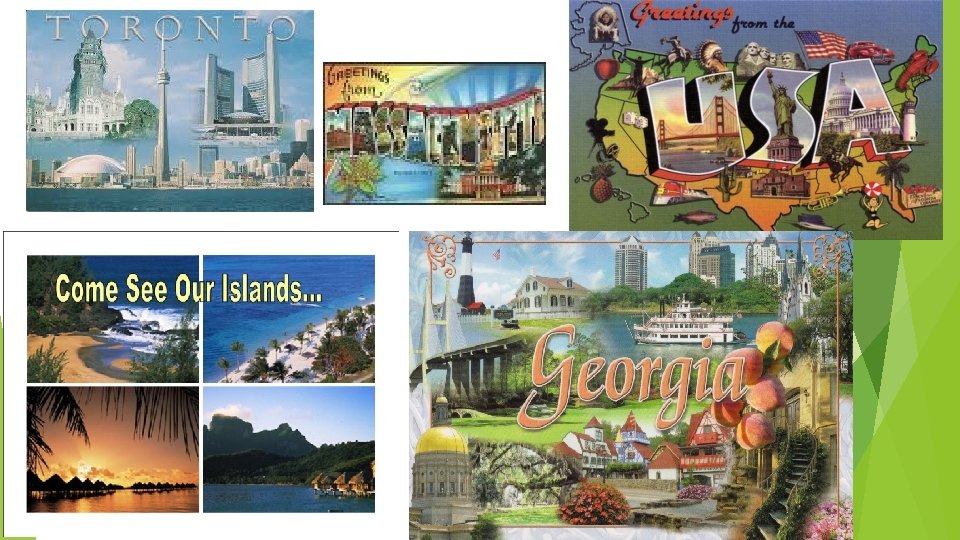
Postcard- Five Themes of Geography You will use all that you know about the 5 themes of geography to create a postcard from any place you’d like to go. Requirements: 1. You must use ALL five themes on the notecard. 2. The picture side (the blank side of one notecard) must - be fully colored - include pictures and/or drawings relating the 5 themes to your destination (1 per theme is good. ) - have a slogan (catchy phrase or the location’s name) 3. The written side (other side of notecard) must explain in detail how each of your symbols represent/show the five themes. Grammar and spelling count. You can write this in paragraph form or in list form with explanation. 4. Make it beautiful, colorful, you can type it if you’d like. This is due tomorrow!

WHAT IS POPULATION?

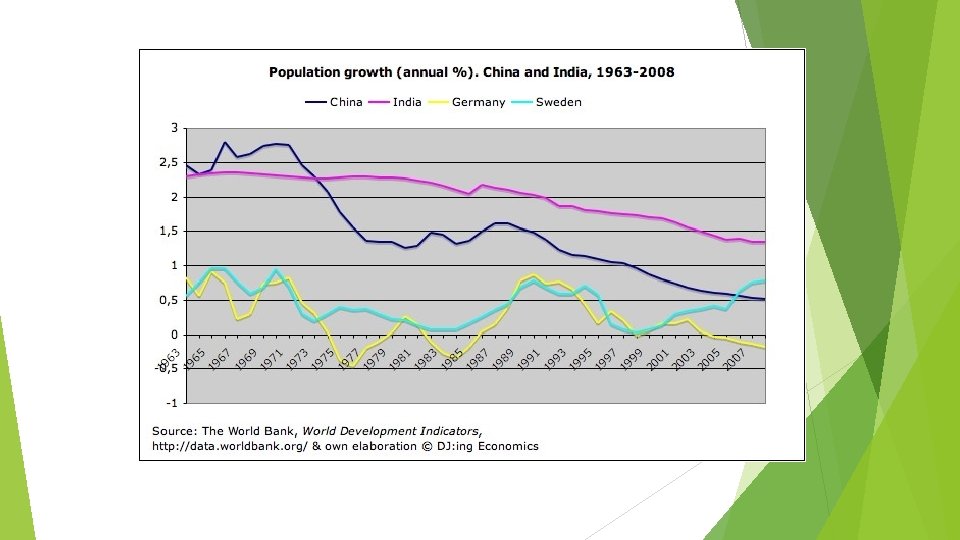
What is population? Geographers use the term population to mean the total number of people who live in a specific area. The population of the world today is more than 7 billion people. Question: What factors might have contributed to our increasing population over time?

Population Distribution and Density Today, the largest populations are found in what are called habitable lands. Only a small portion of the Earth’s surface is suitable for humans to settle. Almost 75% of the Earths surface is water. Habitable lands are lands that are suitable for human living. Video In addition, between 35 and 40 % of the Earth’s land is too hot, too cold, too wet or too dry to live on.

Population Density shows on average how many people are living in a specific size area such as a square mile or square kilometer. To find the population density of a location, add up the total number of people living in an area and divide by the total amount of land they occupy. Demographers are geographers who study the characteristics of human population.

What factors influence population distribution? Environmental factors— What type of natural resources are in the area? Does it have oil, or fertile land or access to water? What is the climate like? Does it have resources such as transportation and technology?

Economic factors- What type of economy does it have? Is the economy strong and making money? Political factors- What is the government policy? Are there many conflicts? Is it a rural/urban area?

The Geography of Population Question: What are some challenges that could result from rapid growth? Ellis Island New York City

Growth Challenges The expanding population creates serious challenges. -In some countries, it is difficult to provide the basic needs of food, clean water and housing. What do YOU think are some challenges to the increasing population? Many people move to the cities to try to make a better life for themselves, but there are not enough materials to build proper shelter or sewers.

Effects of Overcrowding: Japan Shanty houses on the outskirts of a city. Overcrowding: Nigeria

Podcast Question: What are factors that influence where people choose to live? Rural vs. Urban Rural areas that relate to the country or farms. Urban areas refer to cities.

Rural or Urban? Choose: Rural or Urban? Question: Which setting would you prefer to live in? Why? Rural or Urban?

7 Billion and Counting Video https: //www. youtube. com/watch? v=sc 4 Hx. Px. Nr. Z 0 See next slides for propaganda…

Strongly Agree Strongly Disagree Agree Disagree
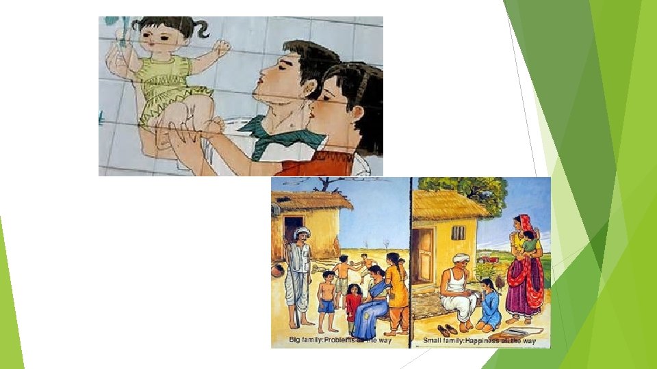

Group Share After considering all of the statements from the four corners activity, what do you think are the biggest issues/problems associated with population?

Group Share What do you think should be done to solve these problems? Who should be responsible?

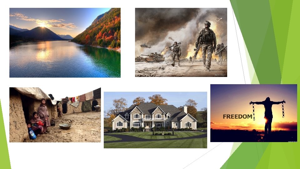
Push/ Pull Factors Push factor- reasons that cause people to leave an area. Pull factor- reasons that attract people to another area Migration Refugee- reasons moving from one place to another a person that flees a place for safety

Push/ Pull Factors Push Pull Diseases in the area Job opportunities War Carowinds- amusemen parks Dislike (prejudice or persecution) Good government Lack of resources Freedom Bad government or failing government Safe neighborhood

Kahoot! https: //play. kahoot. it/#/? quiz. Id=af 25 de 90 -6 c 68 -4 e 25 -8754 -88753 d 708377
- Slides: 76