GEOGRAPHY P 2 REVISION 2829 AC HARRISMITH Topographic


 in block A 6/7 is an")


. . .")


 •")


 on the orthophoto map. Draw")


 4. 1. Study the map below (FIGURE 4.")
. (1 x 2 = 2)")

 of the N 3 that bypasses")
")
 is the")
 approaches Harrismith, hiw")
- Slides: 47
GEOGRAPHY P 2 REVISION 2829 AC HARRISMITH – Topographic Map 2829 AC 3 HARRISMITH – Orthophoto map
Resource Material 1. An extract from topographic map 2829 AC HARRISMITH 2. Ortho photo map 2829 AC 3 HARRISMITH 3. Note: The resource material must be collected by the schools for their own use.
INSTRUCTIONS AND INFORMATION 1. Write your EXAMINATION NUMBER and CENTRE NUMBER in the spaces on the cover page. 2. Answer all questions in the spaces provided on this question paper. 3. You are supplied with a 1: 50 000 map 2829 AC of HARRISMITH and an orthophoto map of a part of the mapped area. 4. You must hand the topographic map and orthophoto to the invigilator at the end of this examination session. 5. You must use the blank page at the back of this paper for all rough work and calculations. Do NOT detach this page from the question paper. 6. Show ALL calculations and formulae, where applicable, Marks will be allocated for this. 7. You may use a non-programmable calculator.
8. The following English term and their Afrikaans translations are shown on the topographical map: ENGLISH Diggings Caravan park Sewerage works River mouth Golf course Wetland AFRIKAANS Uitgrawings Karavaanpark Rioolwerke Rivier mond Gholfbaan Vlei
QUESTION 1: MULTIPLE CHOICE The questions below are based in the 1: 50 000 topographic map 2829 AC HARRISMITH, as well as the orthophoto map of the mapped area. Various options are provided as possible answers to the following questions. Choose the answer and write only the letter (A-D) in the block next to each questions.
1. 1. The main agricultural activity around Harrismith is. . A. B. C. D. crop farming. fruit farming. cattle farming. chicken farming. A
1. 2. The recreational feature marked 1 on the orthophoto map is a. . A. B. C. D. park. nature reserve. golf course. plantation. C
1. 3. On the topographic map, Phomolong (A) in block A 6/7 is an example of a/an. . Residential area. A. B. C. D. high-income low-income middle-income informal B/C
1. 4. Which town is approximately 60 km from Harrismith? A. B. C. D. Van Reenen. Warden. Witsieshoek. Kestell. B
1. 5. The Sterkfontein Dam is to the. . . of the town of Harrismith? A. B. C. D. south-west south-east south west A
1. 6. The map index to the south of 2829 AC is. . . A. B. C. D. 2828 DB. 2829 CA. 2828 BD. 2829 CB. B
1. 7. The river in block C 2 on the topographic map flows in a. . . direction A. B. C. D. south easterly north-easterly southerly north-westerly D
1. 8. The land-use zone numbered 1 on the orthophoto map is a. . . A. recreational area. C. residential area. A/B B. rural-urban fringe. D. plantation.
1. 9. The street pattern in blocks C 1, C 2 and D 2 on the topographic map is a. . . A. B. C. D. planned irregular. a grid. unplanned irregular. radial. A
1. 10. The feature labeled E on the topographic maps is (a). . . A. B. C. D. perennial water. non-perennial water. Marsh and vlei. non-perennial river. C E
QUESTION 2: CALCULATIONS AND APPLICATION 2. 1. Harrismith holds an annual marathon that involves contestants running via Platberg. Study the photograph of Platberg and the area covered by blocks A/B 10, 11, 12 and 13 on the topographic map before answering the questions below.
Photo and sketch as per question paper.
A/B 10, 11, 12 and 13 on the topographic map
2. 1. 1. Identify the landform named Platberg. (1 x 1 = 1) • Mesa • Table mountain
2. 1. 2. Identify the shape of the slope that the contestants will be running up between points C-D (block A/B 10) on the topographic map. Explain your answer with reference to the contours lines in the map. ( • Slope: Concave • Explanation: Lower contour far apart – gradual and Higher contours near to each other steep (2 x 1 = 2) D C
2. 1. 3. Calculate the average gradient of the slope between spot height 1797 and spot height 2263 in block A 10 on the topographic map. Show all calculations. (5) Height: 2263 m – 1797 m = 466 m Distance: 3. 85 cm x 500 = 1925 m (variance ) G=H/D = 466 m ÷ 466 1925 m÷ 466 = 1: 4. 13 (variance 3. 96 – 4. 3)
2. 1. 4. Comment on the level of difficulty of this slope for contestants. (1 x 1 = 1) Very difficult as it is very steep. The ratio of the gradient is 1: 4 – very steep. 2. 1. 5. Explain why a zig-zag footpath (block A 11) has been cut over Platberg. (1 x 1 = 1) It is too steep to go straight up / level out ascent Easier to walk / run up longer less steep path The longer path make the going a bit more level
2. 2. Using the information on the topographic map, determine the magnetic declination for this year. Show all calculations / steps followed. (4 x 1 = 4) 2012 – 2001 = 11 yrs x 8’ W = 88’W = 1º 28’W 20º 28’W + 1º 28’W = 21º 56’W
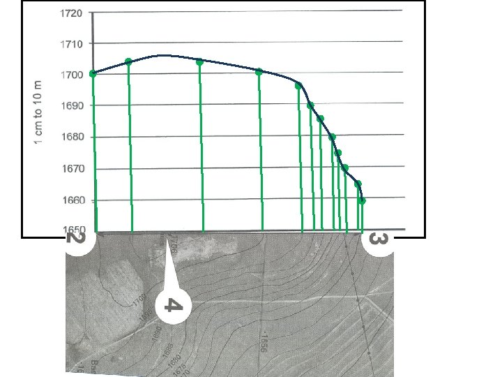
2. 3. Refer to the feature labelled Blokhuis (4) on the orthophoto map. Draw a cross section on the feature from 2 to 3 on the axes below. (12 x ½ = 6)
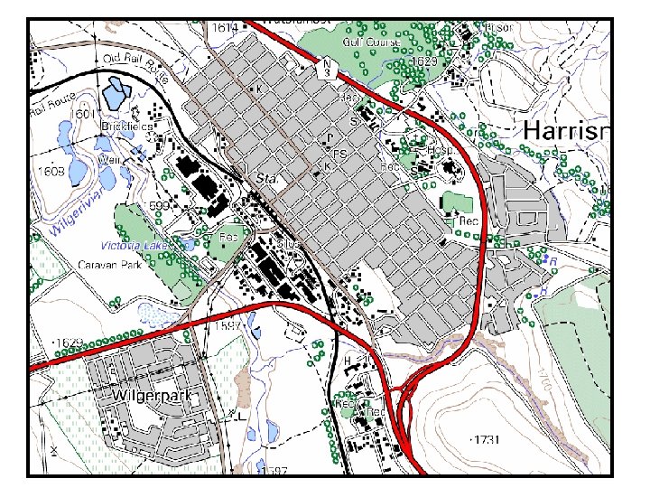
QUESTION 3: APPLICATION AND INTERPRETATION 3. 1. The Sterkfontein Dam forms an important part of the Tugela-Vaal Scheme. Refer to the diagram below (FIGURE 3. 1) as well as the dam on the topographical map to answer the questions that follow.
3. 1. 1. Describe the difference in position of the Sterkfontein Dam in relation to the Spioenkop, Driel, Woodstock and Killburn Dams. (1 x 2 = 2) • Sterkfontein is higher tha the other dams • Sterkfontein is on the escarpment – other on slopes • Sterkfontein dam is NW of other dams. 3. 1. 2. The Sterkfontein Dam has an ideal liation for the storage of water. Give ONE reason to support this statement. (1 x 2 = 2) • • • High Altitude / cooler – less evaporation Deep valleys form natural basin for dam Deep valleys – less surface water – less evaporation Damwall can be short in narrow valleys – cheaper to build Basalt layers underneath forms aqucluides and reduces infiltration.
3. 1. 3. Name TWO ways in which the residents of Harrismith and its surrounding area can benefit from the Sterkfontein Dam. (1 x 2 = 2) Hydro power Recreation Industrial use Domestic use Agricultural / Irrigation • Prevent flooding • Tourist attraction – generates income • • •
3. 2. Harrismith is located in a low-rainfall area. Give two pieces of evidence from the map to support this statement. (2 x 2 = 4) • Non-perennial rivers • Many wind pumps • Reservoirs / Dams to store water • Dongas and erosion furrows indicate erosion after periods of drought • Unpredictable rainfall • High rainfall area? • Season rainfall?
3. 3. Identify the drainage pattern in blocks E/F 3, and 5 and give evidence from the map to support you answer. (2 x 2 = 4) • Radial / Centrifugal • High central point streams diverge from highest part in all different direction.
3. 4. Refer to the Nuwejaarsspruit in block G 2 on the topographic map. 3. 4. 1. Is this a perennial or non-perennial river? (1 x 2 = 2) Perennial 3. 4. 2. Nuwejaarspruit is in its middle course, changing to the lower course. Give TWO pieces of evidence from the map to support this statement. (2 x 2 = 4) Meanders, Oxbow lakes, Gentle gradient, wide floodplain, perennial river
3. 5. Harrismith is a very old town that developed in the colonial era. Support his statement with ONE piece of evidence from the map. (1 x 2 = 2) • Battle sites of Anglo. Boer War • Monuments • Place names referring to the colonial powers
3. 6. Refer to the dominant primary activity practiced in blocks H 1 and H 2. 3. 6. 1. Identify the dominant primary activity referred to above. Mining (1 x 2 = 2) 3. 6. 2. Explain how the environment is likely to be affected by this activity identified in QUESTION 3. 6. 1. in a negative way? (1 x 2 = 2) Deforestation Unsightly Dust Groundwater contamination Loss of top soil and vegetation
3. 8. Refer to the N 3.
3. 7. 1. Why does the N 3 NOT pass through Harrismith? (1 x 2 = 2) Less traffic in town Less accidents in town Less pollution in town Do not slow traffic Bypass town 3. 7. 2. What are the disadvantage for businesses of the N 3 not passing through Harrismith? (1 x 2 = 2) Less customers Less income Economic stagnation Expensive to transport staff and goods to one-stops along freeway / N 3
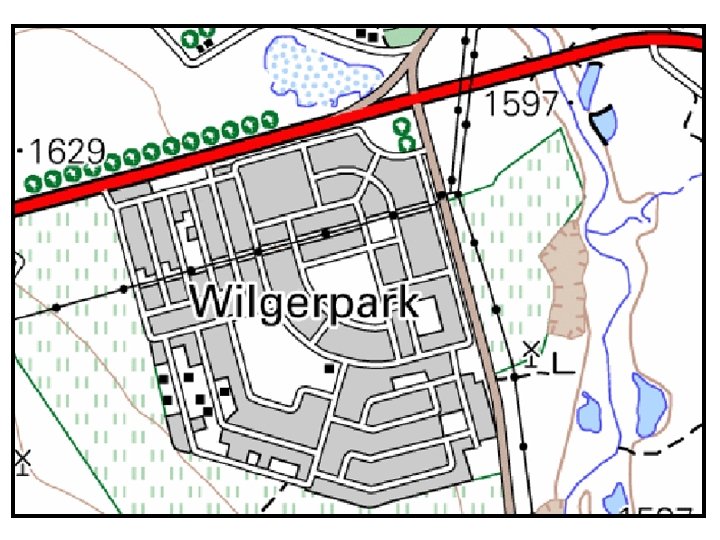
3. 8. Refer to Wilgerpark on the orthophoto map.
3. 8. 1. Wilgerpark developed much later that the original town of Harrismith. Give ONE reason from the orthophoto map to support this statement. (1 x 2 = 2) Modern street pattern – planned irregular On the outskirts of town Newly established gardens – no large trees 3. 8. 2. Wilgerpark is a high-income residential area. Give one piece of evidence from the topographic map to support your answer. (1 x 2 = 2) Large house / properties North facing slopes / favourable microclimate River view and park like surroundings Far from industries Accessible for private transport 3. 8. 3. Give one disadvantage of the location of Wilgerpark. (1 x 2 = 2) Far from business areas Power lines unsightly Lower part near floodplain of river Limited development
QUESTION 4: GEOGRAPHIC INFORMATION SYSTEMS (GIS) 4. 1. Study the map below (FIGURE 4. 1) which shows the path of the tornado that tore through Harrismith a few years ago. Many data layers were used to draw this map.
4. 1. 1. Define the term data layering (overlaying). (1 x 2 = 2) Layering: organising geographic features in GIS to fit over each other – data management process. Overlay: spatial analysis process where one geographic feature is compared to another to find spatial relationship e. g. river and area in danger of flooding along roads – new layer flood prone road spots. 4. 1. 2. Name TWO data layers visible on the map. (2 x 2 = 4) Path of tornado, Settlements, Roads, Contours, Airfield, Dam
4. 1. 3. GIS is useful in disaster management. Explain how it would have assisted the local authorities with planning after the tornado struck. (2 x 2 = 4) Identified damaged areas / Disaster zone Estimate value of damages / insurance Identify safe areas and evacuation routes Identify optional transport routes and air fields Coordinate clean-up operation Plan how and where to remove rubble to
4. 2. Study the photo (FIGURE 4. 2) of the N 3 that bypasses Harrismith and connects Durban with Johannesburg.
4. 2. 1. Differentiate between spatial and attribute data. (2 x 2 = 4) Spatial data is the shape and the location of geographic feature stored as either points, lines or polygons or pixels in a GIS database. Attribute data describe geographic features by naming, identifying, ordering, classifying, measuring the data. This is stored in tables and can be displayed as labelled / annotations or as part of the chosen legend / key. Data that quantifies and qualifies geographic features
4. 2. 2. Which type of spatial object (point, line or polygon) is the road? (1 x 2 =2) Line 4. 2. 3. Give ONE attribute that can be captured for the N 3. (1 x 2 =2) Name – N 3 Number of lanes Speed Bi-direction or not Surface of the road (Tar / conditions) Type of road – National freeway Traffic capacity
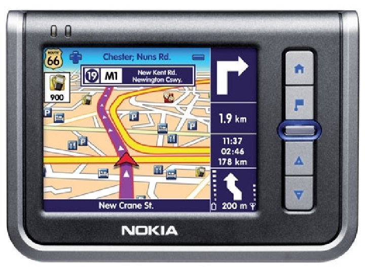
4. 3. If a vehicle with a global positioning system (GPS) approaches Harrismith, hiw can the GPS assist the driver to find the hospital numbered 10 on the orthophoto map? (1 x 2 = 2) Navigate to the hospital / tell where it is / Will indicate where to turn Maps and satellites pin points car and hospital and find shortest route and instructs driver GPS will indicate distance, time to travel and arrival time to and at hospital Can also give alternative routes is a road is blocked or there is a detour