Geography of Southern Eastern Asia QUIZ Southern Eastern


, Thailand, Laos, Cambodia, and Vietnam. One of")


- Slides: 58
Geography of Southern & Eastern Asia QUIZ
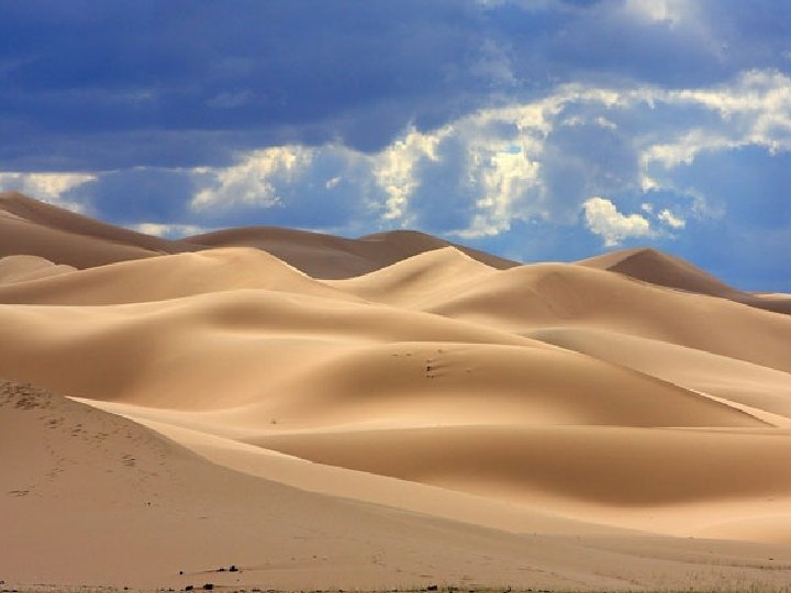
Southern & Eastern Asia Physical Features 1 IDENTIFY
Asia’s largest desert that stretches across southern Mongolia and northern China.
IDENTIFY 2
HINT
HINT: China’s second largest river that causes devastating floods. It is named for the muddy yellow silt it carries
Southern & Eastern Asia Physical Features 3
HINT
HINT Largest and longest river in China; very important because it provides hydroelectric power, water for irrigation, and transportation for cargo ships.
Southern & Eastern Asia Physical Features 4
HINT
HINT : Flows through China, Myanmar (Burma), Thailand, Laos, Cambodia, and Vietnam. One of the region’s most important crops, rice, is grown in the river basin.
Southern & Eastern Asia Physical Features 5
HINT
HINT : Starts in the Himalayan Mountains; most important river in India because it runs through the most fertile and highly populated areas; considered sacred by the Hindu religion.
Southern & Eastern Asia Physical Features 6
HINT
HINT : World’s highest mountain range that sits along the northern edge of India; includes Mount Everest, the highest mountain in the world.
Southern & Eastern Asia Physical Features 7
HINT
HINT : Located in northwestern China between two mountain ranges
Southern & Eastern Asia Physical Features 8
HINT
HINT : Begins high in the Himalayas and slowly runs through India and Pakistan; provides water for one of the largest irrigation systems in the world
Southern & Eastern Asia Physical Features 9
HINT
HINT : Third largest ocean; lies between Africa, Asia, and Australia
Southern & Eastern Asia Physical Features 10
HINT
HINT : An “arm” of the Indian Ocean with India on its west; many large rivers, including the Ganges, flow into it
Southern & Eastern Asia Physical Features 11
HINT
HINT : Lies between Vietnam and the Philippines; has violent monsoons and typhoons.
Southern & Eastern Asia Physical Features 12
HINT
HINT : An “arm” of the Pacific Ocean that lies between China and Korea; it becomes the East China Sea south of the Korean Peninsula
Southern & Eastern Asia Physical Features 13
HINT
HINT : Extends out from China in between the Yellow Sea and the Sea of Japan; divided into two countries
Southern & Eastern Asia Physical Features 14
HINT
HINT : An “arm” of the Pacific Ocean that lies between the continent of Asia and Japan
15
16
17
18
19
20
21
LONGITUDE LATITUDE CHECK
22. Latitude lines run around the globe in a/an ______ direction. They really measure the distance from the ________.
23. The boundary separating the northern and southern hemispheres is the ______.
24. Another name for latitude lines is ________ because they are always the same distance apart. Latitude tells how far ______ or _____ of the equator you are.
25. Longitude lines, also called ______, run in a north-south direction and meet at the poles. The one going through Greenwich, England is the first, or _________.
26. The prime meridian divides the globe into two hemispheres. The on the left is the __________ and the on the right is the __________.
27. Longitude tells how far ____ or _____ of the prime meridian you are.
28. When coordinates are given, the one that is always given first is ______.