GEOGRAPHY OF EGYPT LAND OF THE PHARAOHS PRIOR


- Slides: 19
GEOGRAPHY OF EGYPT LAND OF THE PHARAOHS
PRIOR KNOWLEDGE What do you know of Egypt and ancient Egyptians?
WHERE IS EGYPT? Google Earth
“GIFT OF THE NILE”
IRRIGATION AND THE NILE
IRRIGATION The shadoof is an ancient device used for lifting water from the Nile in places where irrigation could be slightly difficult or to obtain smaller quantities of water. There devices are still used today.
THE “CREATOR OF ALL GOOD” The Nile, like the Euphrates and the Tigris, was fundamental to the development of Egyptian civilization as it brought food and other riches. Reflection Question: How does the growth of Fredericton compare to the early civilizations of Mesopotamia and Egypt?
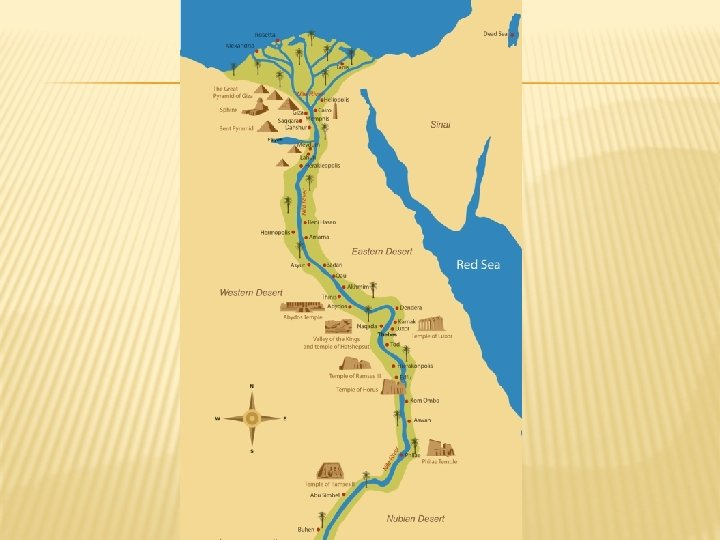
THE NILE RIVER Every year floods cover the banks of the Nile River with rich soil- which makes it a perfect spot for growing crops. It provided drinking water. It was a “natural highway” that linked communities together.
RED LAND Deserts lie to the east and west of the Nile Valley. The Egyptians called this the Deshret or Redland. These deserts provided protection from invasion. They were a source of copper, gold, and graniteused for building, jewelry, tools, weapons…etc…
REDLAND/DESHRET To the west of Egypt is the Libyan Desert that contained six fertile oases called wadis. These Wadis were under Egyptian control and two of these became important suppliers of wine and salt which was used for embalming the bodies for burial. Wadi Natrun
BLACK LAND The fertile land surrounding the Nile River was known as the Kemet or Blackland, because of the rich, black mud left on the banks after a flood from heavy rains in central Africa.
UPPER AND LOWER EGYPT Upper Egypt was marked by the Nile River Valley, and was surrounded by the deserts. It was referred to as Tashema. What about this map seems odd?
UPPER EGYPT
LOWER EGYPT
THE NILE DELTA Lower Egypt was marked by different branches of the Nile River which created a fertile triangular plain. It was referred to as The Nile Delta or the ta-mehu. It was important for trade routes and emptied into the Mediterranean Sea.
NILE CATARACTS Cataracts are shallow parts of a river that can be classified as rapids. During the dry season these rapids are impassable by boat but during the flood season boats can pass easily.
EGYPT & MESOPOTAMIA Unlike Mesopotamia which was subject to constant invasions, Egypt was blessed with the natural barriers of the desert to protect from invasion. Because of this protection, and isolation, Egyptian society and culture was marked by a remarkable degree of continuity over thousands of year.
Question To Consider Did Mesopotamia experience similar consistencies with culture and societies like the Egyptians? Explain. Based on what we have learned about Mesopotamia and Egyptian geography, what might historians look for when searching for ancient civilizations or developments?