Geography of Africa Africa The Tropical Continent Tropic


- Slides: 43
Geography of Africa
Africa: The “Tropical” Continent Tropic of Cancer 20° N Equator 0° Tropic of Capricorn 20° S
# Second largest continent 11, 700, 000 sq. mi. # 10% of the world’s population. # 2 ½ times the size of the U. S.
as Atl ed Sahel Nig er R iv ift Val Great R f. A lf o Gu L. Chad--> <-- er ley Nile River Equator 0° L. Tanganyika-> ori hari a l a K rt River e. Limpopo Des Orange River Mts. rg bu s n aje Dr Pacific Ocean t Tropic of Capricorn 20° S Zambezi River Indian Ocean s. Mt r ese ib D Nam Atlantic Ocean nz we Ru Co den L. Albert--> r Δ Mt. Kenya ve i R o ng L. Victoria Δ Mt. Kilimanjaro Of AFRICA a Se Sahara Desert Complete Topography Libyan Desert Tropic of Cancer 20° N R The Mediterranean Sea s. Mt
Landforms • Africa is a large plateau with escarpments on the edges. • An escarpment is similar to a cliff although not as steep. • Africa has a smooth coastline with few natural harbors.
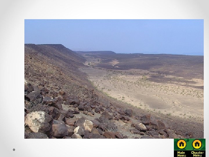
Map showing escarpments on the edge of the plateau and rift valleys in East Africa.
Plains ift Val ley & Great R Valleys
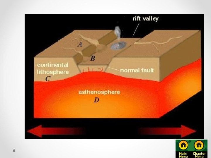
Rift Valleys • Divergent plate activity formed the Great Rift Valley in East Africa. • In some areas the Great Rift Valley is hundreds of miles wide. • Rift valleys extend from The Red Sea to South Africa.
Rift Valley, Kenya
Rift Valleys • A. B. East Africa has several large lakes that formed in the bottom of rift valleys. Lake Victoria Lake Tanganyika
Great Rift Valley 3, 000 miles long
ts. M s tla A Mountains & Peaks Δ Mt. Kenya . ts i. M or z en w Ru Δ Mt. Kilimanjaro . ts g r bu D s en j ra M
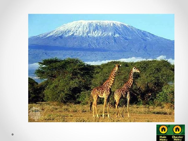
Mountains • The highest mountains are the Atlas Mountains in the northwest, near the Mediterranean Sea. They rise to 13, 600 feet (4, 160 m) above sea level. • Sub-Saharan Africa does not have large mountain ranges, but there are several tall mountains that are volcanoes. • The tallest mountain is Mt. Kilimanjaro in Tanzania at 19, 341 feet. • The second tallest mountain is Mt. Kenya at 17, 058 feet.
Mt. Kilimanjaro: Snow on the Equator?
Mediterranean Sea R a Se Nig Nile River er R ive L. Chad--> r <-- Water den f. A lf o Gu Of ed Bodies r L. e. Albert--> iv R o ng L. Victoria o C L. Tanganyika-> Indian Ocean Atlantic Ocean Zambezi River Limpopo River Orange River Pacific Ocean
Map showing major rivers in Africa
Nile River • The Nile River is the longest river in the world. o Flows more than 4, 000 miles northward through the desert o Formed by the union of two rivers, the Blue Nile and the White Nile o Empties into the Mediterranean Sea • The land along the Nile is very fertile. o Floods on the river deposit silt, or finely ground fertile soil, all along the river. o Before it reaches the sea, the Nile fans out into a huge fertile delta.
The Congo River Basin # Covers 12% of the continent. # Extends over 9 countries. # 2, 720 miles long. # 99% of the country of Zaire is in the Congo River basin.
The Niger River Basin # Covers 7. 5% of the continent. # Extends over 10 countries. # 2, 600 miles long.
Cataracts or rapids on the Zambezi River
Hydroelectric Power
• Aswan High Damo Controls the Nile River o Lake Nasser was created behind it o Finished in 1970 o Benefits • Fewer floods • More farmable land
Climate Zones
Vegetation Zones
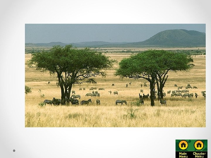
The African Savannah: 13 million sq. mi.
Savannah
Grasslands • Savanna is a type of grassland located in tropical wet and dry climates. • Most of the savanna in Africa is located in east Africa in Kenya or Tanzania. • Steppe is a dry grassland located on the edges of the deserts.
The Sahel
• Sahel- narrow band of dry grassland on the southern edge of the Sahara.
The Sahel
Libyan Deserts Sahara Desert Sahel r ese ib D Nam t hari a l a K ert Des
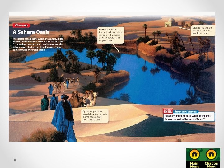
The Sahara Largest hot desert in the world, covering most of North Africa Very dry, so very few people live there Nearly every settlement in the Sahara is located near an oasis, a wet and fertile area in a desert where a spring or well provides water. Common features in the Sahara include broad gravel plains, tall sand dunes, and dry streambeds.
Sahara Desert
The Sahara Desert
Map that shows the relative location of the Namib and Kalihari Deserts. Notice how the deserts are in North and South Africa.
• Desertificationexpansion of dry conditions into moist areas that are next to deserts. o Major problem for the Sahel region
Desertification
African Rain Forest # Annual rainfall of up to 17 ft. # Rapid decomposition (very humid). # Covers 37 countries. # 15% of the land surface of Africa.