Geographic Information Systems SGO 1910 SGO 4030 October

Geographic Information Systems SGO 1910, SGO 4030 October 18, 2005

Quizzes n n Class average: 24, 8 Two problem questions – I concede!

19. Efforts to promote an international standard for ellipsoids has led to the wide acceptance of the North American Datum of 1927 (NAD 27) (False, WGS 84 or NAD 83) but… ”many older data still adhere to earlier standards, such as NAD 27” (p. 116) 24. The modern history of GIS dates from the early 1950 s, when computers were developed. (False – ”the modern history of GIS dates from the early 1950 s, when the price of sufficiently powerful computers fell below a critical threshold” p. 18)

20. Geographic techniques can be applied to non-geographic spaces. True ”But many of the methods used in GIS are also applicable to other non-geographic spaces, including the surfaces of other planets, the space of the cosmos, and the space of the human body that is captured by medical images” (p. 8) n

n n n 27. If you were going hiking in the forest, it would be most useful to take along a map with a small representative fraction. FALSE 1: 50000 > 1: 1000000 30. Digital representations of geographic phenomena are formalized through photographic models. FALSE
 GIS Data Collection GPS Chapter 9 n Week")
Revised Schedule Week 42 (October 18) GIS Data Collection GPS Chapter 9 n Week 43 (October 25) Geographic Databases Chapters 10 n Week 44 (Nov. 1) Geographic Analysis Chapters 14, 15 Week 45 (Nov. 8) Mid-term Quiz II Map Production Chapter 12 GIS and Society Chapter 18 n n n Week 46 (Nov. 15) n Week 47 (November 22) NO CLASS n Week 48 Final Exam Dec 1

Uncertainty

The more scientific knowledge we gain, the more uncertain we are likely to be: “Richness of representation and computational power only make us more aware of the range and variety of established uncertainties, and challenge us to integrate new ones” (Longley et al. 2005, p. 152).

Data Acquisition: Getting the Map into the Computer
 Secondary")
Data capture n n Primary (direct measurement, e. g. remote sensing and surveying) Secondary (derivation from other sources; digitizing, scanning, etc. )

Data transfer n Input of data from other systems (via Internet, CD ROMs, tapes, etc. )

GIS maps are digital n n Real maps: traditional paper maps that can be touched Virtual maps: an arrangement of information inside the computer; the GIS can be used to generate the map however and whenever necessary.

GIS Data Conversion n n Traditionally the most time-consuming and expensive part of a GIS project Involves a one-time cost Digital maps can be reused and shared. Requires maintenance (eg. updating)

GIS data can be n n n Purchased. Found from existing sources in digital form. Captured from analog maps by GEOCODING.

Finding Existing Map Data n n n Map libraries Reference books State and local agencies Federal agencies Commercial data suppliers

Existing Map Data n n Existing map data can be found through a map library, via network searches, or on media such as CD-ROM and disk. Many major data providers make their data available via the Internet.

Statenskartverk http: //ngis. statkart. no/katalog/java/katalog. asp n n n Rasterdata Temakart Vektordata Primærdata Prosjekter

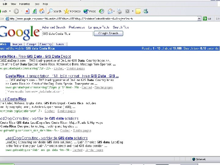
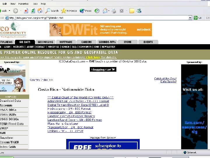
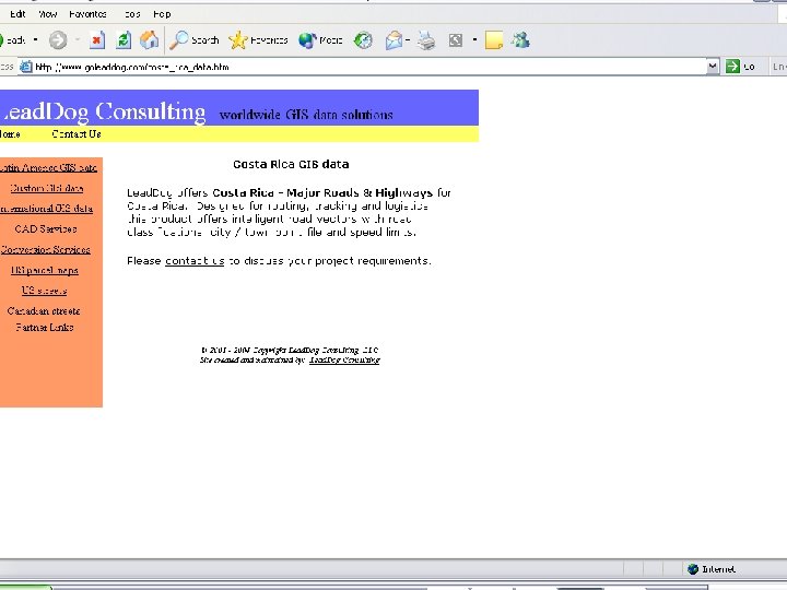
1. Accessing GIS Data n Example: Costa Rica

Data Collection n One of most expensive GIS activities Many diverse sources Two broad types of collection n Data capture (direct collection) Data transfer Two broad capture methods n n Primary (direct measurement) Secondary (indirect derivation)

Data Collection Techniques Raster Primary Secondary Vector Digital remote sensing images GPS measurements Digital aerial photographs Survey measurements Scanned maps Topographic surveys DEMs from maps Toponymy data sets from atlases

GEOCODING n n Geocoding is the conversion of spatial information into digital form. Geocoding involves capturing the map, and sometimes also capturing the attributes.

Primary Data Capture n n Capture specifically for GIS use Raster – remote sensing n n n e. g. SPOT and IKONOS satellites and aerial photography Passive and active sensors Resolution is key consideration n Spatial Spectral Temporal

Secondary Geographic Data Capture n n Data collected for other purposes can be converted for use in GIS Raster conversion n n Scanning of maps, aerial photographs, documents, etc Important scanning parameters are spatial and spectral (bit depth) resolution

Vector Primary Data Capture n Surveying n n Locations of objects determines by angle and distance measurements from known locations Uses expensive field equipment and crews Most accurate method for large scale, small areas GPS n n Collection of satellites used to fix locations on Earth’s surface Differential GPS used to improve accuracy

Vector Secondary Data Capture n n Collection of vector objects from maps, photographs, plans, etc. Digitizing n n Manual (table) Heads-up and vectorization Photogrammetry – the science and technology of making measurements from photographs, etc. COGO – Coordinate Geometry

Managing Data Capture Projects n Key principles n n Fundamental tradeoff between n n Quality, speed and price Two strategies n n n Clear plan, adequate resources, appropriate funding, and sufficient time Incremental ‘Blitzkrieg’ (all at once) Alternative resource options n n In house Specialist external agency

Summary n n n Data collection is very expensive, timeconsuming, tedious and error prone Good procedures required for large scale collection projects Main techniques n Primary n n n Raster – e. g. remote sensing Vector – e. g. field survey Secondary n n Raster – e. g. scanning Vector – e. g. table digitizing

Digitizing n n n Captures map data by tracing lines from a map by hand Uses a cursor and an electronically-sensitive tablet Result is a string of points with (x, y) values

Digitizer

The Digitizing Tablet map Pulse is picked up by nearest grid wires under tablet surface. Result is sent to computer after conversion to x and y units. Digitizer cursor transmits a pulse from an electomagnetic coil under the view lens.

Digitizing n n n n Stable base map Fix to tablet Digitize control Determine coordinate transformation Trace features Proof plot Edit Clean and build

Selecting points to digitize

Scanner

Scanning n n n Places a map on a glass plate, and passes a light beam over it Measures the reflected light intensity Result is a grid of pixels Image size and resolution are important Features can “drop out”

Scanning example

Field data collection

Pen Portable PC and GPS

Data Transfer n n n Buy vs build is an important question Many widely distributed sources of GI Key catalogs include n n n US NSDI Clearinghouse network Geography Network Access technologies n n Translation Direct read

Attribute data n n Logically can be thought of as in a flat file Table with rows and columns Attributes by records Entries called values.

Database Management Systems n n n Data definition module sets constraints on the attribute values Data entry module to enter and correct values Data management system for storage and retrieval Data definitions can be listed as a data dictionary Database manager checks values with this dictionary, enforcing data validation.

The Role of Error n n Map and attribute data errors are the data producer's responsibility, but the GIS user must understand error. Accuracy and precision of map and attribute data in a GIS affect all other operations, especially when maps are compared across scales.
 Sources of information: http: //www. trimble. com/gps/ http:")
Part II: Global Positioning Systems (GPS) Sources of information: http: //www. trimble. com/gps/ http: //www. colorado. edu/geography/gcraft/notes/gps. html#DODSystem

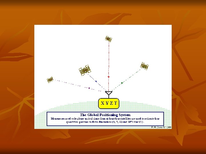
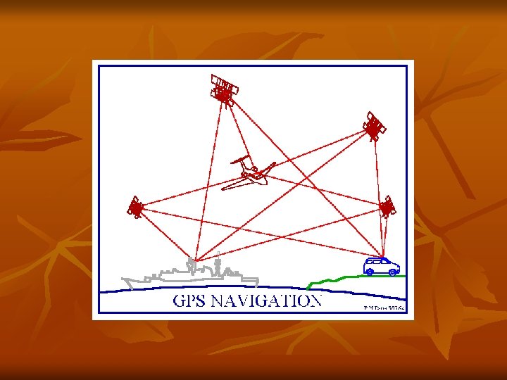
GPS is a Satellite Navigation System n n n GPS is funded by and controlled by the U. S. Department of Defense (DOD). While there are many thousands of civil users of GPS world-wide, the system was designed for and is operated by the U. S. military. GPS provides specially coded satellite signals that can be processed in a GPS receiver, enabling the receiver to compute position, velocity and time. Four GPS satellite signals are used to compute positions in three dimensions and the time offset in the receiver clock.

Space Segment n The Space Segment of the system consists of the GPS satellites. These space vehicles (SVs) send radio signals from space.
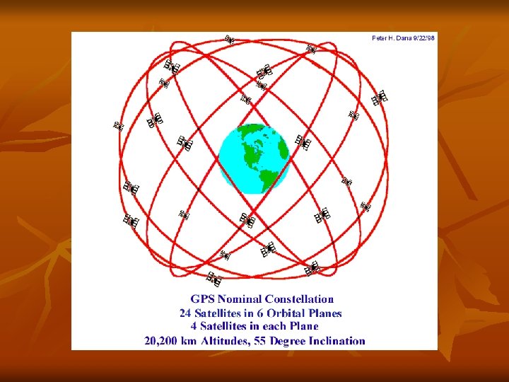
 n n The nominal GPS Operational Constellation consists of 24 satellites")
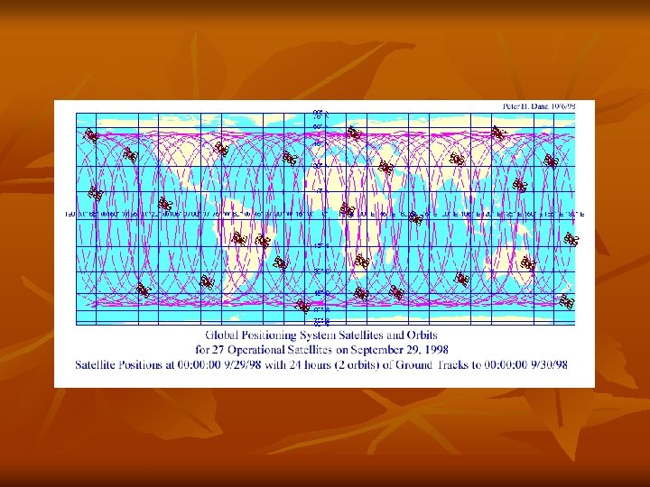
Space Segment (cont) n n The nominal GPS Operational Constellation consists of 24 satellites that orbit the earth in 12 hours. The satellite orbits repeat almost the same ground track (as the earth turns beneath them) once each day. The orbit altitude is such that the satellites repeat the same track and configuration over any point approximately each 24 hours (4 minutes earlier each day). There are six orbital planes (with nominally four SVs in each), equally spaced (60 degrees apart), and inclined at about fiftyfive degrees with respect to the equatorial plane. This constellation provides the user with between five and eight SVs visible from any point on the earth.

GPS Satellites Name: NAVSTAR Manufacturer: Rockwell International Altitude: 10, 900 nautical miles Weight: 1900 lbs (in orbit) Size: 17 ft with solar panels extended Orbital Period: 12 hours Orbital Plane: 55 degrees to equitorial plane Planned Lifespan: 7. 5 years Current constellation: 24 Block II production satellites Future satellites: 21 Block IIrs developed by Martin Marietta
, is")
Latest Development n Galileo, Europe's contribution to the Global Navigation Satellite System (GNSS), is creating a buzz in the Global Positioning Systems (GPS) applications market. With its advantages of signal reliability and integrity, it is poised to drive European GPS applications markets. Unlike its US counterpart, Galileo is envisioned as being independent of military control and is expected to be harnessed for widespread commercial and civilian purposes. (Space Daily, Dec. 18, 2003)

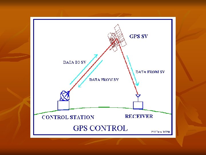
Control Segment n The Control Segment consists of a system of tracking stations located around the world.
")
The Master Control facility is located at Schriever Air Force Base (formerly Falcon AFB) in Colorado. These monitor stations measure signals from the SVs which are incorporated into orbital models for each satellites. The models compute precise orbital data (ephemeris) and SV clock corrections for each satellite. The Master Control station uploads ephemeris and clock data to the SVs. The SVs then send subsets of the orbital ephemeris data to GPS receivers over radio signals.

User Segment n n The GPS User Segment consists of the GPS receivers and the user community. GPS receivers convert SV signals into position, velocity, and time estimates. Four satellites are required to compute the four dimensions of X, Y, Z (position) and Time. GPS receivers are used for navigation, positioning, time dissemination, and other research. Navigation in three dimensions is the primary function of GPS. Navigation receivers are made for aircraft, ships, ground vehicles, and for hand carrying by individuals.

n Precise positioning is possible using GPS receivers at reference locations providing corrections and relative positioning data for remote receivers. Surveying, geodetic control, and plate tectonic studies are examples.

Here's how GPS works in five logical steps: n n n The basis of GPS is "triangulation" from satellites. To "triangulate, " a GPS receiver measures distance using the travel time of radio signals. To measure travel time, GPS needs very accurate timing which it achieves with some tricks. Along with distance, you need to know exactly where the satellites are in space. High orbits and careful monitoring are the secret. Finally you must correct for any delays the signal experiences as it travels through the atmosphere.
 to satellites. Mathematically we")
Triangulating n n Position is calculated from distance measurements (ranges) to satellites. Mathematically we need four satellite ranges to determine exact position. Three ranges are enough if we reject ridiculous answers or use other tricks. Another range is required for technical reasons to be discussed later.

Measuring Distance n n Distance to a satellite is determined by measuring how long a radio signal takes to reach us from that satellite. To make the measurement we assume that both the satellite and our receiver are generating the same pseudo-random codes at exactly the same time. By comparing how late the satellite's pseudo-random code appears compared to our receiver's code, we determine how long it took to reach us. Multiply that travel time by the speed of light and you've got distance.

Getting Perfect Timing n n n Accurate timing is the key to measuring distance to satellites. Satellites are accurate because they have atomic clocks on board. Receiver clocks don't have to be too accurate because an extra satellite range measurement can remove errors.
 shared the Nobel")
2005 Nobel Prize in Physics n Two physicists (Hall and Haensch) shared the Nobel Prize in Physics for advancing the developmetn of laser-based precision spectroscopy, a field htat opens the way to the next generation of global positioning system (GPS) navigation and ultra-precise atomic clocks.

Satellite Positions n n To use the satellites as references for range measurements we need to know exactly where they are. GPS satellites are so high up their orbits are very predictable. Minor variations in their orbits are measured by the U. S. Department of Defense. The error information is sent to the satellites, to be transmitted along with the timing signals.

n n Three satellites could be used determine three position dimensions with a perfect receiver clock. In practice this is rarely possible and three SVs are used to compute a two-dimensional, horizontal fix (in latitude and longitude) given an assumed height. This is often possible at sea or in altimeter equipped aircraft. Five or more satellites can provide position, time and redundancy. More SVs can provide extra position fix certainty and can allow detection of out-of-tolerance signals under certain circumstances.

n n Position in XYZ is converted within the receiver to geodetic latitude, longitude and height above the ellipsoid. Latitude and longitude are usually provided in the geodetic datum on which GPS is based (WGS-84). Receivers can often be set to convert to other userrequired datums. Position offsets of hundreds of meters can result from using the wrong datum.

GPS errors are a combination of noise, bias, blunders.
 n n SA is the intentional degradation of the SPS signals")
Selective Availability (SA) n n SA is the intentional degradation of the SPS signals by a time varying bias. SA is controlled by the DOD to limit accuracy for non-U. S. military and government users. SA was turned off in May, 2000!

Bias Error sources n n n SV clock errors uncorrected by Control Segment : 1 meter Ephemeris data errors: 1 meter Tropospheric delays: 1 meter. The troposphere is the lower part (ground level to from 8 to 13 km) of the atmosphere that experiences the changes in temperature, pressure, and humidity associated with weather changes. Complex models of tropospheric delay require estimates or measurements of these parameters. Unmodeled ionosphere delays: 10 meters. The ionosphere is the layer of the atmosphere from 50 to 500 km that consists of ionized air. The transmitted model can only remove about half of the possible 70 ns of delay leaving a ten meter un-modeled residual. Multipath: 0. 5 meters. Multipath is caused by reflected signals from surfaces near the receiver that can either interfere with or be mistaken for the signal that follows the straight line path from the satellite. Multipath is difficult to detect and sometime hard to avoid.

Blunders can result in errors of hundred of kilometers. n n n Control segment mistakes due to computer or human error can cause errors from one meter to hundreds of kilometers. User mistakes, including incorrect geodetic datum selection, can cause errors from 1 to hundreds of meters. Receiver errors from software or hardware failures can cause blunder errors of any size.

Correcting Errors n n n The earth's ionosphere and atmosphere cause delays in the GPS signal that translate into position errors. Some errors can be factored out using mathematics and modeling. The configuration of the satellites in the sky can magnify other errors. Differential GPS can eliminate almost all error.

n GPS technology has matured into a resource that goes far beyond its original design goals. These days scientists, sportsmen, farmers, soldiers, pilots, surveyors, hikers, delivery drivers, sailors, dispatchers, lumberjacks, firefighters, and people from many other walks of life are using GPS in ways that make their work more productive, safer, and sometimes even easier.

Location: Where am I? n The first and most obvious application of GPS is the simple determination of a "position" or location. GPS is the first positioning system to offer highly precise location data for any point on the planet, in any weather. That alone would be enough to qualify it as a major utility, but the accuracy of GPS and the creativity of its users is pushing it into some surprising realms.

Navigation: Where am I going? n n GPS helps you determine exactly where you are, but sometimes important to know how to get somewhere else. GPS was originally designed to provide navigation information for ships and planes. So it's no surprise that while this technology is appropriate for navigating on water, it's also very useful in the air and on the land. The sea, one of our oldest channels of transportation, has been revolutionized by GPS, the newest navigation technology.

n n By providing more precise navigation tools and accurate landing systems, GPS not only makes flying safer, but also more efficient. With precise point-to-point navigation, GPS saves fuel and extends an aircraft's range by ensuring pilots don't stray from the most direct routes to their destinations. GPS accuracy will also allow closer aircraft separations on more direct routes, which in turn means more planes can occupy our limited airspace. This is especially helpful when you're landing a plane in the middle of mountains. And small medical evac helicopters benefit from the extra minutes saved by the accuracy of GPS navigation.

n n Finding your way across the land is an ancient art and science. The stars, the compass, and good memory for landmarks helped you get from here to there. Even advice from someone along the way came into play. But, landmarks change, stars shift position, and compasses are affected by magnets and weather. And if you've ever sought directions from a local, you know it can just add to the confusion. The situation has never been perfect. Today hikers, bikers, skiers, and drivers apply GPS to the ageold challenge of finding their way.

n “In 1994 Norwegian Borge Ousland reached the North Pole after skiing 1000 kilometers from Siberia alone and unsupported. For this incredible challenge Børge carried a bible to read, some Jimi Hendrix to listen to, and a Trimble Scout GPS receiver to help find his way. ”

Tracking n n Commerce relies on fleets of vehicles to deliver goods and services either across a crowded city or through nationwide corridors. So, effective fleet management has direct bottom-line implications, such as telling a customer when a package will arrive, spacing buses for the best scheduled service, directing the nearest ambulance to an accident, or helping tankers avoid hazards. GPS used in conjunction with communication links and computers can benefit applications in agriculture, mass transit, urban delivery, public safety, and vessel and vehicle tracking. So it's no surprise that police, ambulance, and fire departments are adopting GPS-based AVL (Automatic Vehicle Location) Manager to pinpoint both the location of the emergency and the location of the nearest response vehicle on a computer map. With this kind of clear visual picture of the situation, dispatchers can react immediately and confidently.

Timing n n n Although GPS is well-known for locating, navigation, and tracking, it's also used to disseminate precise time, time intervals, and frequency. Time is a powerful commodity, and exact time is more powerful still. Knowing that a group of timed events is perfectly synchronized is often very important. GPS makes the job of "synchronizing our watches" easy and reliable. There are three fundamental ways we use time. As a universal marker, time tells us when things happened or when they will. As a way to synchronize people, events, even other types of signals, time helps keep the world on schedule. And as a way to tell how long things last, time provides and accurate, unambiguous sense of duration. GPS satellites carry highly accurate atomic clocks. And in order for the system to work, our GPS receivers here on the ground synchronize themselves to these clocks. That means that every GPS receiver is, in essence, an atomic accuracy clock.

Mapping n n Using GPS to survey and map it precisely saves time and money in this most stringent of all applications. Today, Trimble GPS makes it possible for a single surveyor to accomplish in a day what used to take weeks with an entire team. And they can do their work with a higher level of accuracy than ever before. GPS technology is now the method of choice for performing control surveys, and the effect on surveying in general has been considerable. GPS pinpoints a position, a route, and a fleet of vehicles. Mapping is the art and science of using GPS to locate items, then create maps and models of everything in the world. Mountains, rivers, forests and other landforms. Roads, routes, and city streets. Endangered animals, precious minerals and all sorts of resources. Damage and disasters, trash and archeological treasures. GPS is mapping the world.
- Slides: 86