Geografi Politik dan Geopolitik Pengertian Geografi Politik dan


 – State resembles a biological organism – birth,")


")
 – view the world")

")


 Gibraltar’s absolute location")


 • contesting")
")

- Slides: 50
Geografi Politik dan Geopolitik
Pengertian Geografi Politik dan Geopolitik Political geography is the field of human geography that is concerned with the study of both the spatially uneven outcomes of political processes and the ways in which political processes are themselves affected by spatial structures. Conventionally political geography adopts a three-scale structure for the purposes of analysis with the study of the state at the centre, above this is the study of international relations (or geopolitics), and below it is the study of localities. The primary concerns of the sub-discipline can be summarised as the inter-relationships between people, state, and territory The term geopolitics reflects the connection between power and interests, strategic decision-making, and geographic space. Academically, the study of geopolitics involves the analysis of geography, history and social science with reference to spatial politics and patterns at various scales. It is multidisciplinary in its scope, and includes all aspects of the social sciences with particular emphasis on political geography, international relations, the territorial aspects of political science and international law. [3]Also, the study of geopolitics includes the study of the ensemble of relations between the interests of international political actors, interests focused to an area, space, geographical element or ways, relations which create a geopolitical system
Nation • Geographers’ definition: community of people with common ancestry, culture and territory • Does not imply an independent political unit • e. g. Quebec; Acadians in Eastern Canada; “First Nations” throughout Canada
• Geopolitics: Friedrich Ratzel (Ger) – State resembles a biological organism – birth, maturity, decline, death – Nourishment through acquisition of less powerful territories; space is essential – “Organic Theory” (stated above): led to expansionist Nazi policies of 1930 s • Heartland Theory: Halford Mackinder (Br) – Heart of Eurasia – resource-rich, land-based “pivot area”, E. Eur is key to World Island • Rimland Theory: Nicholas Spykman (US) – Eurasian rim, not heart – key to global power
Mackinder’s Heartland Theory & Spykman’s Rimland Theory
• Evolution of Boundaries – Boundary – a vertical plane that cuts through the subsoil & airspace (even outer space) – Definition – legal document or treaty drawn up to specify actual points in the landscape – Delimitation – cartographers put the boundary on the map – Demarcation – boundary is actually marked on the ground w/ wall, fence, posts, … • Types of Boundaries – Geometric – straight-line, unrelated to physical or cultural landscape, lat & long (US/Canada) – Physical-political (natural-political) – conform to physiologic features (Rio Grande: US/Mexico; Pyrenees: Spain/France) – Cultural-political – mark breaks in the human landscape (Armenia/Azerbaijan)
• Origin-Based Classification – a. k. a. genetic boundary types – Antecedent – existed before the cultural landscape emerged – Subsequent – developed contemporaneously with the evolution of the cultural landscape – Superimposed – placed by powerful outsiders on a developed landscape, usually ignores pre-existing cultural-spatial patterns – Relict – has ceased to function, but its imprint can still be detected on the cultural landscape • Frontier – zone of separation, a territorial “cushion” that keeps rivals apart
• Boundary Disputes – Definitional – focus on legal language (e. g. median line of a river: water levels may vary) – Locational – definition is not in dispute, the interpretation is; allows mapmakers to delimit boundaries in various ways – Operational – neighbors differ over the way the boundary should function (migration, smuggling) – Allocational – disputes over rights to natural resources (gas, oil, water)
Major area of dispute w/ Iraq in 1990 s Relative Location of Kuwait
Iron Curtain NATO “Above” the State Boundaries
Geopolitik: Organisasi Negara dan Kekuatan Nasional (Interest)
• Core-Periphery Model – World Systems Analysis (Immanuel Wallerstein) – view the world as an interlocked system of states – Core – economically dominant states – Periphery – developing states; have little autonomy or influence – Semi-periphery – middle; keeps the world from being polarized into two extremes – The world must be seen as a system of interlinking parts; ties political and economic geography together
• Core areas – center, heart; relates to scale – State – national heartland: largest pop. , most productive region, greatest centrality, may contain the capital (multicore – Nigeria, US) – Region – several economically strong states • Capital city – pol. nerve center, seat of gov’t, center of nat. life, & nat. headquarters • Forward capital – capital city moved for a nat. objective; culture, disputed territory, … • Primate city – state’s largest city; most expressive of culture, may be capital: Mexico City, Paris, Jakarta, … (many countries don’t have: e. g. US)
• Centripetal Forces – promote unity – Charismatic leaders, external threats ( Iraq) – Nationalism – religion, education, national ideology, … • Centrifugal Forces – divisive forces – Internal religious, linguistic, ethnic, or ideological differences – Tribalism – people identify more w/ their local affiliation than with their country
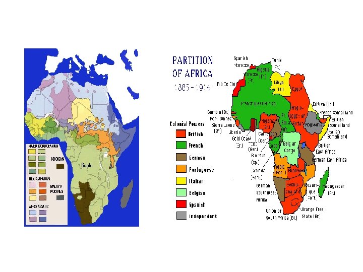
Colonialism has changed the global order of politics; often creating unequal cultural and economic relations
Colonized regions of the world
Geographic Characteristics of States • Size - important for resources, power, governance, communication – Russian Federation- 17, 075, 000 km 2 Nauru 20 km 2 • Shape - for governance/transport • Location - Absolute & Relative
Location • Absolute Location – Position with respect to grid (lat/long) Gibraltar’s absolute location is 36° 09 N 5° 21 W • Relative Location – Position with respect to other states and regions. Gibraltar’s relative location is crucial as a British colony at the entrance to the Mediterranean Sea.
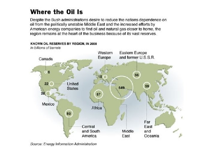
Strategic Locations • Relative locations of importance to two or more states • Military or economic significance • differs over time – e. g. results of change from wind to coal to petroleum as fuel for shipping • many Straits are good examples -Malacca, Bosphorus, Bering Strait, Strait of Hormuz, Strait of Gibraltar • Canals – Suez, Panama Strategic Location of oil resources in Iraq/Kuwait. n
Strategic location: oil geopolitics & formation of OPEC • 1960 - OPEC founded in Baghdad by Iraq, Iran, Kuwait, Saudi Arabia and Venezuela to win better return for oil producers whose output is controlled by Western multinationals. • 1973 - An Arab oil embargo during Arab-Israeli war disrupts oil flows and triggers panic buying. • OPEC countries wrest pricing fully from Western multinationals in first "Oil Shock" and prices soar from around $2. 50 a barrel in January 1973 to $11. 50 by 1974.
Pipeline Development: SE Asia Straits of Malacca • 1/4 of total world commodity trade • 1/2 of all world’s oil shipments • 2/3 of total liquidfied natural gas • • Economic development of impoverished nations Social, environmental, and cultural change: ‘modernization’ and resistance to it e. g. Kra isthmus, Thailand
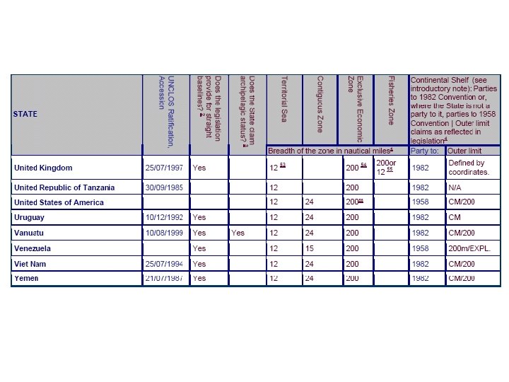
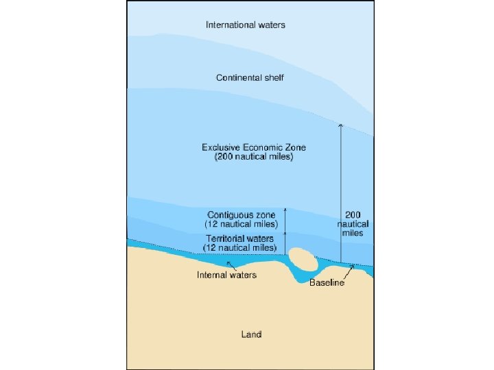
• Law of the Sea – Needed because of the weakness of the older 'freedom of the seas' concept, dating from the 17 th century: national rights limited to 3 nautical miles. All water beyond national boundaries was considered international waters - free to all nations, but belonging to none of them. – In the 20 th century many nations expressed a need to extend national claims. In 1945 President Truman extended the US’s control to cover all the natural resources of its continental shelf. – Other nations were quick to emulate the USA. Between 1946 and 1950, Argentina, Chile, Peru, and Ecuador all extended their sovereign rights to a 200 nautical miles distance, to cover fishing grounds. Other nations extended their territorial seas to 12 nautical miles. – As of 2006, only a handful of countries use the old 3 miles limit (Jordan, Palau, and Singapore, and others).
• Exclusive economic zone: Under the Law of the Sea, an Exclusive Economic Zone (EEZ) is a sea zone over which a state has rights to the exploration and use of marine resources.
Pressures on state primacy • Over the centuries, power has changed hands from church to state to corporations • Trends that weaken a state: 1. 2. 3. 4. 5. Globalization of economy, transnational corporations Proliferation of international institutions Emergence of NGOs (non-governmental organizations) International migration Increase in nationalist and separatist movements
International political organizations • Today there is more globalization and homogenization • When a state joins an international organization, it must give up some of its sovereignty • Examples: UN, WHO, UNICEF, the World Bank, IMF, EU, NATO • NATO: North Atlantic Treaty Organization – a military alliance – The member states agree to defend each other if attacked by an external party
Political Geography
Political geography vocabulary • State: an area organized into a political unit and ruled by an established government that has control over its internal and foreign affairs (sovereignty) – – Defined territory, permanent population Synonym for country A nation is not a country, but rather the people A formal region
• Sovereignty: independence from control of its internal affairs by other states – A sovereign state has control over its affairs – Internal: laws, print money – External: treaties, passports (diplomatic relationships with other states) – Tribal governments are not sovereign, but they have autonomy
• Nation-state: a sovereign state inhabited by a homogeneous group of people who share a feeling of common nationality. – Examples: • Japan (most Japanese are in Japan) • Poland – By contrast, most countries are multi-ethnic
• Stateless nation: people without their own state – Kurds live in Iraq, Eastern Turkey, Iran, Syria http: //img. timeinc. net/time/daily/special/photo/salgado/kurds. jpg
http: //www. globalsecurity. org/military/world/iraq/images/kurdistan 1. gif
• Number: approximately 200 countries in the world
Regional Organizations Worldwide Source: Wikipedia
Supranational Entities in Eurasia
GROWTH OF THE EU
GROWTH OF THE EU
N I A CORE D O M ? ? AN EX TIC PA IPA NS TE IO D N
CONFIRMATION OF CORE-DOMAIN MODEL
Terms to enhance discussion of geopolitical discourses • Geopolitical codes – Particular constructions of “us” and “them” • E. g. Evil Empire, hyperpower, failed state, a people in exile, God’s chosen people, members of a protectorate, etc. – Particular constructions of space, place, and time • E. g. manifest destiny, mission civilisatrice, “a land without people for a people without land, ” the march of progress, lebensraum, etc. • Narrative appeals – The moral of a geopolitical tale – Tragic, comic, romantic or ironic in nature • E. g. “once again we’ve been ripped off” (tragic), “once again we’ve been obligated to save the world” (romantic), “once again our ties to [insert state name] have benefited us, ” etc. • All such appeals are constructions rather than facts • Omissions – Very little can be said in a news article – What facts or conditions were left out of the story and how might they have interfered with the geopolitical codes and narrative appeals in the story?
The driving question • Q. What is geography good for? • A. Defense and conquest. – This, at least, is the oldest and most common answer to the question! – geography was important to the Roman Empire, the Chinese Dynasties, the British Empire, & the expanding U. S. (19 th c. ) • “Realist” approach to foreign policy – based on assumption that world is governed by force rather than cooperation – Appropriate foreign policies either subdue other countries or contain them – Alternative, “Kantian” approach is based on assumption that power politics do not provide lasting solutions and states must cooperate
Uses of geographical info. • settlement (planting colonists and resisting "the natives") • contesting claims of other potential colonizers • waging war (against "natives" and other colonizers) • justifying the struggle for regional or global domination
H. Mackinder’s "heartland" theory (1904)
cold war “containment”