Geodata meta data and Georeferencing Concepts Paper Geoinformatics
 V Semester 2020")
. By")
")

. By viewing data")


, GIS (geographical information systems), and RS (remote")

 These are points/cross sections of know coordinates")


- Slides: 20
Geo-data, meta data and Geo-referencing Concepts Paper: Geoinformatics BSc (Hons. ) V Semester 2020 -21
Geodata Concept Geodata is location information stored in a Geographic Information System (GIS). By viewing data with a geographic component, we see it through a different lens. Geodata tackles the problem about location because geographic problems require spatial thinking Geospatial data, or spatial data (as it's sometimes known), is information that has a geographic aspect to it. In other words, the records in this type of information set have coordinates, an address, city, postal code, or zip code included with them. The most obvious example is a road map. Methods for Creating Spatial Databases Manual Digitizing. This is traditionally the most common way to convert paper-based sources of spatial information (e. g. maps) to digital data. . Heads up digitizing. . Coordinate Geometry (COGO). . . Geocoding. . Global Positioning Systems (GPS). . . Image Processing. . Related GIS Data Resources:
Digitizing Table (Now obsolete)
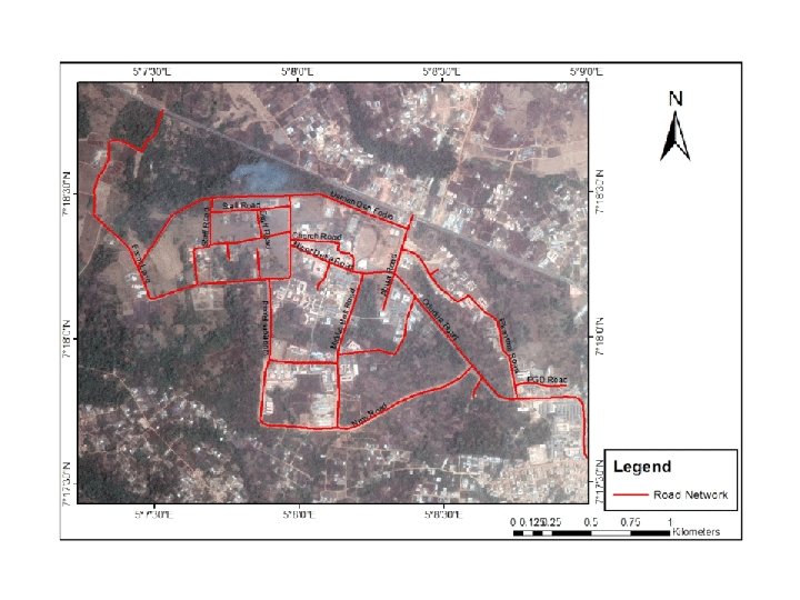
Now Ob-screen digitization is the common method Maps/Images and other data sets are displayed on the monitor And digitized on screen directly. Features are digitized as Points Lines Polygons While digitizing one commits errors and mistakes in features extraction. Errors are removed in editing module Features are kept as points, lines and polygons in separate files We call them Coverage. Point coverage, line coverage and polygon coverage
Geodata is location information stored in a Geographic Information System (GIS). By viewing data with a geographic component, we see it through a different lens. Geodata tackles the problem about location because geographic problems require spatial thinking. Let’s dive into the types, themes and sources of geodata. 1. Vector Files Vector data consists of vertices and paths. The three basic types of vector data are points, lines and polygons (areas). Each point, line and polygon has a spatial reference frame such as latitude and longitude. First, vector points are simply XY coordinates. Secondly, vector lines connect each point or vertex with paths in a particular order. Finally, polygons join a set of vertices. But it encloses the first and last vertices creating a polygon area. 2 Raster Files Raster data is made up of pixels or grid cells. Commonly, they are square and regularly-spaced. But rasters can be rectangular as well. Rasters associate values to each pixel. Continuous rasters have values that gradually change such as elevation or temperature. But discrete rasters set each pixel to a specific class. For example, we represent land cover classes to a set of values.
3 Geographic Database The purpose of geographic databases is to house vectors and rasters. Databases store geographic data as a structured set of data/information. For example, Esri geodatabases, geopackages and Spatia. Lite are the most common types of geographic databases. We use geographic databases because it’s a way to put all data in a single container. Within this container, we can build networks, create mosaics and do versioning. 4 Web Files As the internet becomes the largest library in the world, geodata has adapted with its own types of storage and access. For example, Geo. JSON, Geo. RSS and web mapping services (WMS) were built specifically to serve and display geographic features over the internet. Additionally, online platforms such as Esri’s Arc. GIS Online allow organizations to build data warehouses in the cloud. 5 Multi-temporal data attaches a time component to information. But multitemporal geodata not only has a time component, but a geographic component as well. For example, weather and climate data tracks how temperature and meteorological information changes in time in a geographical context. Other examples of multi-temporal geodata are demographic trends, land use patterns and lightning strikes.
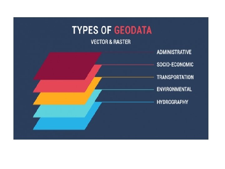
You can group geodata into as many themes as you want. They can be as broad or as narrow to your liking. Here are examples of geographic themes: Cultural • Administrative (Boundaries, cities and planning) • Socioeconomic data (Demographics, economy and crime) • Transportation (Roads, railways and airport) Physical • Environmental data (Agriculture, soils and climate) • Hydrography data (Oceans, lakes and rivers) • Elevation data (Terrain and relief)
Geospatial technology involves GPS (global positioning systems), GIS (geographical information systems), and RS (remote sensing). Geospatial data is data about objects, events, or phenomena that have a location on the surface of the earth. . Much geospatial data is of general interest to a wide range of users. For example, roads, localities, water bodies, and public amenities are useful as reference information for a number of purposes. Geospatial means. . . consisting of, derived from, or relating to data that is directly linked to specific geographical locations If the data set consists of geographical information, it is called spatial (or geospatial) mining. Geospatial analytics gathers, manipulates and displays geographic information system (GIS) data and imagery including GPS and satellite photographs. Geospatial data analytics rely on geographic coordinates and specific identifiers such as street address and zip code.
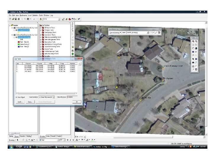
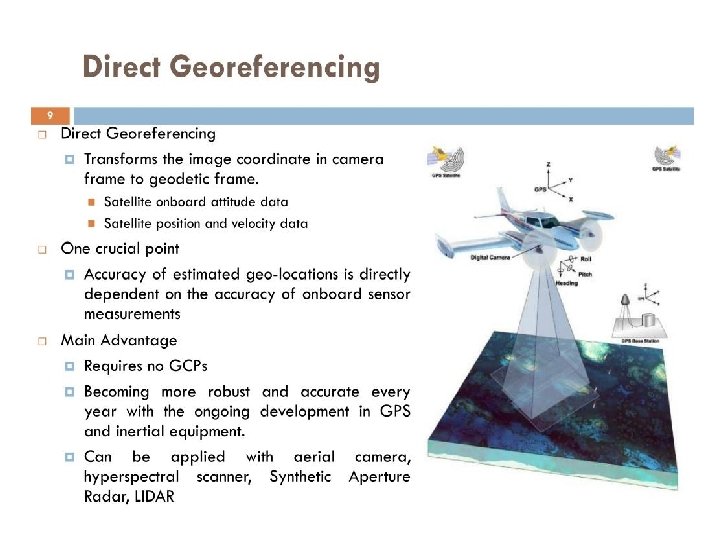
Concept of Geocoding: process of transforming a description of a location—such as a pair of coordinates, an address, or a name of a place— to a location on the earth's surface. You can geocode by entering one location description at a time or by providing many of them at once in a table. Geocoding is the process of translating street addresses into geographic latitude and longitude coordinates for accuracy. Every business needs a well-developed map with zones of locations to provide an understanding of where people are, where they were, and the activities that took place. Geocoding vs Georeferencing Geocoding is the process of taking coded location information (such as addresses or grids) and turning it into explicit location information (X and Y coordinates, usually). . Georeferencing involves fitting an image to the Earth based on matching up visual features of the image with their known location. Georeferencing means that the internal coordinate system of a digital map or aerial photo can be related to a ground system of geographic coordinates. Georeferencing is the process of taking a digital image, it could be an airphoto, a scanned geologic map, or a picture of a topographic map, and adding geographic information to the image so that GIS or mapping software can 'place' the image in its appropriate real world location.
Steps for Georeferencing Ground Control Points (GCPs) These are points/cross sections of know coordinates (Lat-long) We require at least 4 GCPs to geo-reference the map/image GCPs should be evenly distributed over the study area They should be points of permanent nature i. e. not shifting with time Railway bridge, road intersections, dams, rail-road crossing etc GCPs are transferred from the toposheet/map to the image one by one Once all GCPs are done, it gives RMS (Root mean square error) RMS is a measure of accuracy, It should always be <1. 0
Concept of Metadata is data that describes other data. Meta is a prefix that in most information technology usages means "an underlying definition or description. “ Metadata summarizes basic information about data, which can make finding and working with particular instances of data easier. For example, author, date created and date modified and file size are examples of very basic document metadata. The ability to filter through that metadata makes it much easier for someone to locate a specific document. In addition to document files, metadata is used for images, videos, spreadsheets and web pages. The use of metadata on web pages can be very important. Metadata for web pages contain descriptions of the page’s contents, as well as keywords linked to the content. These are usually expressed in the form of metatags. The metadata containing the web page’s description and summary is often displayed in search results by search engines, making its accuracy and details very important since it can determine whether a user decides to visit the site or not.
Three types of metadata: Technical metadata, business metadata and process metadata. Technical metadata is primarily definitional, while business metadata and process metadata is primarily descriptive. Elements of a metadata: Title/Name – Name given to the resource. Description – A description of the resource and its spatial, temporal or subject coverage. Format – File format, physical medium, dimensions of the resource, or hardware and software needed to access the data. Metadata can be created manually, or by automated information processing. Manual creation tends to be more accurate, allowing the user to input any information they feel is relevant or needed to help describe the file. Automated metadata creation can be much more elementary, usually only displaying information such as file size, file extension, when the file was created and who created the file.
Metadata is created and collected because it enables and improves use of that data. Good metadata can make up for human fallibilities. . Metadata also makes text documents easier to find because it explains exactly what the document is about. Metadata summarizes basic information about data, which can make finding and working with particular instances of data easier. For example, author, date created and date modified and file size are examples of very basic document metadata. . The use of metadata on web pages can be very important. Role of Metadata has a very important role in a data warehouse. The role of metadata in a warehouse is different from the warehouse data, yet it plays an important role. . Metadata is used in extraction and cleansing tools. There are three main types of metadata: Descriptive metadata describes a resource for purposes such as discovery and identification. It can include elements such as title, abstract, author, and keywords. Metadata is described by AIIM as the structured information about a document, data or other information content. . Metadata (data about data) is traditionally found in card catalogs in libraries. With the age of digital documents, metadata is used to describe the content of these documents.
Metadata is a set of data that describes and gives information about other data. Photo metadata allows information to be transported with an image file, in a way that can be understood by other software, hardware, and end users, regardless of the format. The data mart is a subset of the data warehouse and is usually oriented to a specific business line or team. Whereas data warehouses have an enterprise-wide depth, the information in data marts pertains to a single department. Metadata provide a powerful tool for tailoring and targeting e-commerce; in a Social Media Today study, 32 percent of respondents reported extremely positive results from using social to pursue client care objectives. Yet, the large amounts of data that such tools may deliver can make it difficult to assess customer engagement. However, organizing and identifying trends within those large-volume data sets supports more effective customer service and marketing outreach. With the addition of Google-specific metadata like authorship and publisher tags, as well as plug-ins provided by CMS like Word. Press, these data analytics can deliver positive effects for a company’s bottom line.