GEO Strategic Plan 2016 2025 GEO is a


 GEOSS is a set of coordinated, independent Earth")
 Comprises: • Observation systems • Data and information")


 Advocate the use of and support the implementation")


 The Earth observation and information systems,")


 Asset")
- Slides: 19
GEO Strategic Plan 2016 -2025 GEO is a coalition of governments and participating organizations having as its mission the implementation of the Global Earth Observation System of Systems (GEOSS) to meet the need for timely, quality long term global information as a basis for sound decision-making. Earth observations from diverse sources, including satellite, airborne, in-situ platforms, and citizen observatories, when integrated together, provide powerful tools for understanding the past and present conditions of Earth systems, as well as the interplay between them.
GEOSS Concept, from the “GEOSS 10 -year Implementation Plan, ” 2005
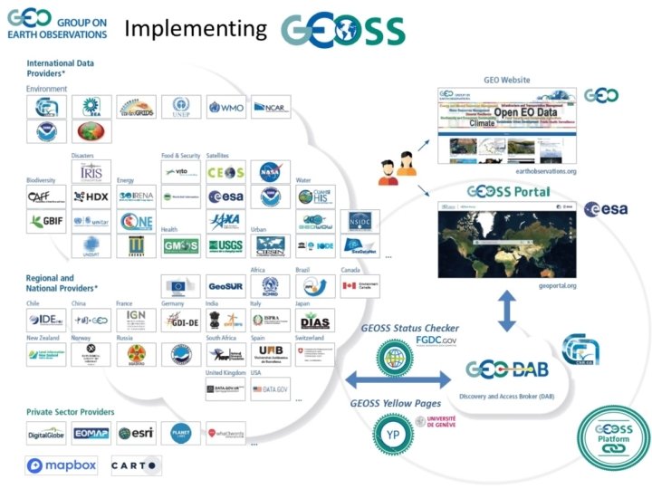
GEOSS (GEO Strategic Plan 2016 -2025) GEOSS is a set of coordinated, independent Earth observation, information and processing systems that interact and provide access to diverse information for a broad range of users in both public and private sectors. GEOSS links these systems to strengthen the monitoring of the state of the Earth. It facilitates the sharing of environmental data and information collected from the large array of observing systems contributed by countries and organizations within GEO. Further, GEOSS ensures that these data are accessible, of identified quality and provenance, and interoperable to support the development of tools and the delivery of information services. Thus, GEOSS increases our understanding of Earth processes and enhances predictive capabilities that underpin sound decision-making. (GEO Strategic Plan 2016 -2025)
GEOSS (GEO Strategic Plan 2016 -2025) Comprises: • Observation systems • Data and information and processing systems Functions • address user requirements; • acquire observational data; • process data into useful products and services; • find, share, integrate and archive data, metadata and products based on the GEOSS Data Sharing and Data Management Principles; and • monitor performance of functionalities against the defined requirements and intended benefits. Principles • Openness • Effectiveness • Sustainability • Reliability
GEO Strategic Plan 2016 -2025 “It is the opinion of the Secretariat the lack of a clear, concise and (most importantly) shared vision and understanding of, and implementation for GEOSS, and the associated and/or resultant lack of commitment (and contributions) from Members and POs, is creating a situation where, unfortunately, in five or ten years, when the Co-Chair from South Africa, and likely others, asks the same question that was asked in March 2016 -that is, ‘Have we, or are we truly delivering on the vision of a “system of systems” as articulated by the founders of GEO? ’, we may not, anymore than today, have a good answer. ” State of Play of GEOSS 37 th Executive Committee – 6 -7 July 2016
Content Some numbers on GEOSS Assets • More than 185 brokered catalogs, • More than 5000 different Data Providers • More than 400 ml resources
Infrastructure functionalites The Enhanced GEOSS Portal
Principles as to interoperability standards: 1) Advocate the use of and support the implementation of international and community standards. (2) Do not impose any existing standard, leaving the multiple GEO Communities of Practice to select and implement the ones they consider most effectively. (3) Support the many standards characterizing the multi-domains covered by GEOSS through the implementation of the mediation/brokering pattern. (4) Maintain and evolve the mediation/brokering capabilities of the GEOSS platform in order to implement the ultimate interoperability standards (the IT landscape changes rapidly) but continuing to support the existing legacy standards.
GEO DAB Supported Standards OGC CSW 2. 0. 2 AP ISO 1. 0 OGC CSW 2. 0. 2 eb. RIM EO OGC CSW 2. 0. 2 eb. RIM CIM ESRI GEOPORTAL 10 OAI-PMH 2. 0 Open. Search 1. 1 ESIP Open. Search GENESI DR CKAN CUAHSI HIS-Central ESRI REST API 10. 3 OGC WCS OGC WMS OGC WFS 1. 0. 0, 1. 1. 0, 2. 0. 0 OGC WMTS OGC SOS 1. 0. 0, 2. 0. 0 Hydro Profile OGC WPS 1. 0. 0 OGC CSW 2. 0. 0 Core OGC CSW 2. 0. 2 AP ISO 1. 0 OGC CSW 2. 0. 2 eb. RIM/EO AP OGC CSW 2. 0. 2 eb. RIM/CIM AP IRIS Station IRIS Event HYRAX THREDDS SERVER 1. 9 OAI-PMH 2. 0 - Harvesting GBIF DIF HYDRO UNAVCO CDI 1. 04, 1. 3, 1. 4 ISO 19115 -2 THREDDS 1. 0. 1, 1. 0. 2 THREDDS-NCISO-PLUS 1. 0. 1, 1. 0. 2 INPE CKAN DCAT GI-cat ESRI GEOPORTAL 10 NCML-OD BCODMO NCML-CF Net. CDF-CF 1. 4 FTP populated with supported metadata types WAF Web Accessible Folders Geo. Network (2. 2. 0 or greater) Ecological Markup Language 2. 1. 1 NERRS (National Estuarine Research Reserve System) HMA CSW 2. 0. 2 eb. RIM/CIM HDF IADC DB (My. SQL) Gr. ADS-DS Fed. EO ARPA DB (based on Microsoft SQL) ESRI Map Server SHAPE files (FTP) KISTERS Web - Environment of Canada Environment Canada Hydrometric data (FTP) Open. Search 1. 1 Earth Engine RASAQM EGASKRO SITAD (Sistema Informativo Territoriale Ambientale Diffuso) File System GDACS Geo. RSS 2. 0 Degree catalog service 2. 2 Open. Search GENESI DR Healthsites API Json Source: http: //www. geodab. net/
Infrastructure Functionalities Towards the GEOSS Platform GEOSS Mirror GEOSS API • Reuse of the GEOSS Portal tailored to resources and themes of your Community • Speed up access and collaboration of the Community GEOSS Widget GEOSS View GEOSS Like Reuse Customise Collaborate Reuse of some GEOSS key functionalities like discovery, access, GEOSS Like To easily connect to GEOSS from other Portals A unique User Feedback System across different Providers to: • Rate • Commenting • Share
GEOSS Platform GWP GEO Knowledge Hub: Digital Library Based on free and open -source solutions (Invenio. RDM) Search for reproducible knowledge Flagship A Zenodo-like interface Digital library services 1) Ingestion 2) Mediation DOI creation Containerized architecture Storage Knowledge Packages Data Code Publications Instances Training material Other resources Vendor neutral Search for data Scalable infrastructure API GEOSS Portal Users Flagship B International Data providers Scale up Vendor neutral computing environment Cloud solution 1 Cloud solution 2 Commercial sector opportunities
Fully Functioning GEOSS comprises three main components: 1) The Earth observation and information systems, which GEO Members and Participating Organizations make available for coordination and access; they include both those already available or planned, and those to be defined and developed within the GEO framework; 2) The GEOSS Common Infrastructure (GCI), developed, operated and maintained by GEO, connecting the data and information from the individual systems, and allowing users to search, discover and access these resources; and 3) A set of principles and guidelines on architecture, data sharing, and data management and data quality that enable reliable and integrated use of data, products and tools. (from the Strategic Plan All three components are essential and concurrent for a fully functioning GEOSS. State of Play of GEOSS 37 th Executive Committee – 6 -7 July 2016
Infrastructure Functionalities Reuse GEOSS Platform: Look & Feel and Functionality … … is available for reuse by other portals to • Align with GEOSS Look & Feel for a ‘one portal’ experience. • Combine GEOSS mapping functionality, search and results display functionality and integrate this together with their own functionality.
Infrastructure Functionalities 1. Reuse Solutions Mirroring and customising the GEOSS Portal site for SBAs, Flagships, Initiatives, Communities GEOSS Mirror It is available at www. geoportal. org/community/GEO_X_Inititiative The customisation will better serve the specific community interests by filtering: • Catalogues and search results by a specific theme or GEO DAB view (e. g. , cold regions, mountains, etc. ) • Location of interests • Services/Processing/Tools (in the future …) (click here for short clip demoing the concept) GEOSS Widget 2. GEOSS widgets A freely-available instantiation of selected GEOSS Portal widgets is available for possible customization in various areas of application (e. g. a specific SBA, Inititiatives, etc. ). • This will be accomplished by publishing portal code parts (widgets) wrapped up in API • Kernel at server side (continue maintenance, enhancements, etc. , like a library)
Infrastructure GEOSS View Functionalities • Subset of the whole GEOSS resources defined by applying a set of clauses • • • Discovery clauses (e. g. spatial envelope, keywords, sources, etc. ) Access clauses (e. g. data format, access protocol, CRS, etc. ) Defined “View” exposed to the GEOSS Portal Consumer-defined View – i. e. Client-side These views are available only for the client application which defined the view. Provider-defined View –i. e. Server-side These views are available for all client applications.
GEOSS APIs Infrastructure Functionalities Different APIs for serving diverse Application development users Geospatial Expert Web Dev. Expert Standard Web Services A set of standard Web service interfaces: • e. g. OGC service interfaces, (OGC Web Services, OAI CKAN, OAI-PMH, X FTP, etc. -PMH, A set. CKAN, of APIs foretc. ) software developers: • Client side APIs: – (high-level) Java. Script library Open. Search (Extended) – …. (Python) • Server side APIs: X REST/JSON GEO DAB–API JS APIs X GEO DAB API REST X – Open. Search APIs – ….
Infrastructure functionalites The Simplified Registration Workflow: GEOSS Yellow Pages Administrative Phase (GEO Sec) Asset to be registered Data Provider fills in a Yellow Page form Supported Standards GEO Sec team validates the entry Users The Asset is now accessible from the GEOSS Portal Brokering Phase (GEO DAB) Webservice end point URL to GEO DAB Team Interoperability tests GCI GEOSS