Genesis and Morphology of the Alberta Dryline Neil
Genesis and Morphology of the Alberta Dryline Neil M. Taylor Hydrometeorology and Arctic Lab MOIP Simulator: Drylines Meteorological Service of Canada
Outline • brief review of dryline ‘theory’ • mechanism responsible for dryline genesis in Alberta • dryline morphology • operational forecast issues • future work 12/11/2021 MOIP Simulator: Drylines 2
The Dryline • strong moisture gradient in the BL (obs at SFC) • dry air: hot -- deep, well mixed boundary layer • moist air: cooler & capped in BL -- dry and well mixed aloft => loaded gun sounding • literature: frontogenetic (wrt moisture) circulation driven mainly by differential heating (e. g. , land breeze effect) • convergence at dryline => convective initiation 12/11/2021 MOIP Simulator: Drylines 3
IMPLICATIONS Dryline Interpretation 12/11/2021 • circulation near dryline important for low-level mesocyclogenesis (tornadoes) • forms capping lid + convergence line a focus for convective initiation • simplest interpretation: storm - no storm boundary (e. g. , too dry => no storms) MOIP Simulator: Drylines 4
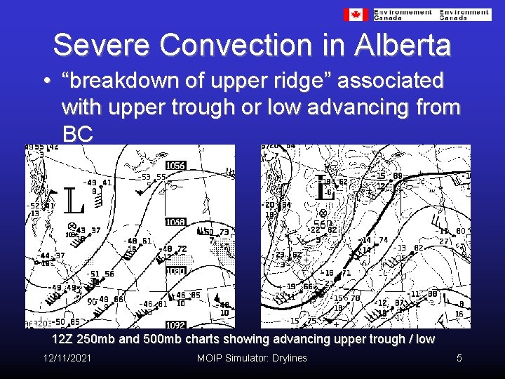
Severe Convection in Alberta • “breakdown of upper ridge” associated with upper trough or low advancing from BC 12 Z 250 mb and 500 mb charts showing advancing upper trough / low 12/11/2021 MOIP Simulator: Drylines 5
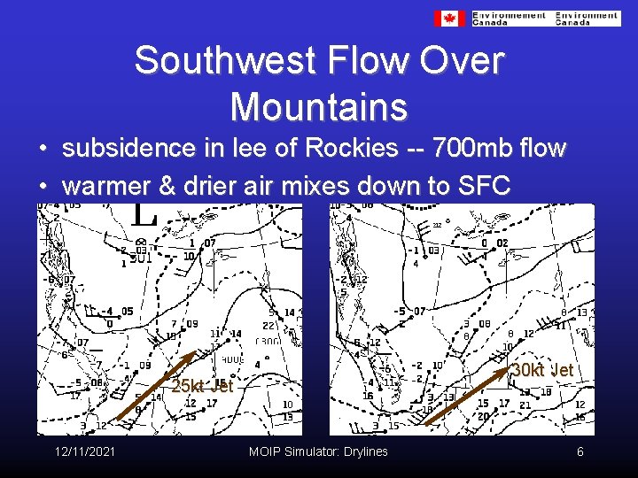
Southwest Flow Over Mountains • subsidence in lee of Rockies -- 700 mb flow • warmer & drier air mixes down to SFC 30 kt Jet 25 kt Jet 12/11/2021 MOIP Simulator: Drylines 6
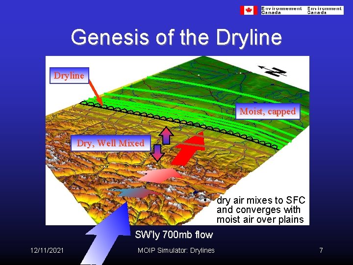
Genesis of the Dryline Moist, capped Dry, Well Mixed • dry air mixes to SFC and converges with moist air over plains SW’ly 700 mb flow 12/11/2021 MOIP Simulator: Drylines 7
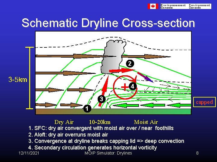
Schematic Dryline Cross-section 2 4 3 capped 1 Dry Air 10 -20 km Moist Air 1. SFC: dry air convergent with moist air over / near foothills 2. Aloft: dry air overruns moist air 3. Convergence at dryline breaks capping lid => deep convection 4. Secondary circulation generates horizontal vorticity 12/11/2021 MOIP Simulator: Drylines 8
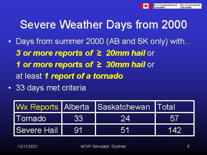
Severe Weather Days from 2000 • Days from summer 2000 (AB and SK only) with. . . 3 or more reports of ≥ 20 mm hail or 1 or more reports of ≥ 30 mm hail or at least 1 report of a tornado • 33 days met criteria Wx Reports Alberta Saskatchewan Total Tornado 33 24 57 Severe Hail 91 51 142 12/11/2021 MOIP Simulator: Drylines 9
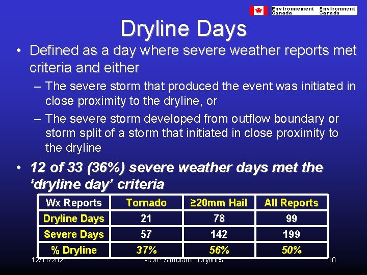
Dryline Days • Defined as a day where severe weather reports met criteria and either – The severe storm that produced the event was initiated in close proximity to the dryline, or – The severe storm developed from outflow boundary or storm split of a storm that initiated in close proximity to the dryline • 12 of 33 (36%) severe weather days met the ‘dryline day’ criteria Wx Reports Tornado ≥ 20 mm Hail All Reports Dryline Days 21 78 99 Severe Days 57 142 199 % Dryline 37% 56% 50% 12/11/2021 MOIP Simulator: Drylines 10
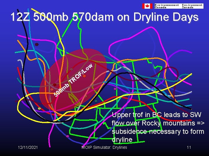
12 Z 500 mb 570 dam on Dryline Days b m 0 0 5 w o /L F O R T Upper trof in BC leads to SW flow over Rocky mountains => subsidence necessary to form dryline 12/11/2021 MOIP Simulator: Drylines 11
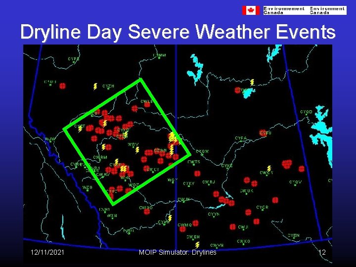
Dryline Day Severe Weather Events 12/11/2021 MOIP Simulator: Drylines 12
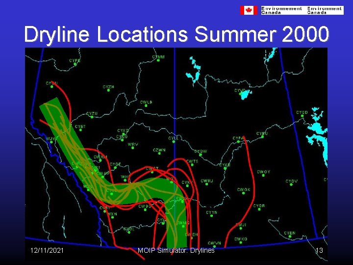
Dryline Locations Summer 2000 12/11/2021 MOIP Simulator: Drylines 13
Dryline Associated Storm Tracks • Considered storms initiated near dryline that produced severe weather (or led to severe storm via outflow boundary cell generation / storm splitting) • Remote sensing used to define a storm track via radar (1. 5 km cappi – first echo to <40 d. BZ), VIS satellite + CLDN lightning flash data • 26 severe thunderstorms initiated near dryline (or led to severe storm development via outflow boundary / splitting) • All 26 storms initiated within 75 km of dryline (61% within 50 km and mean distance of 45 km) 12/11/2021 MOIP Simulator: Drylines 14
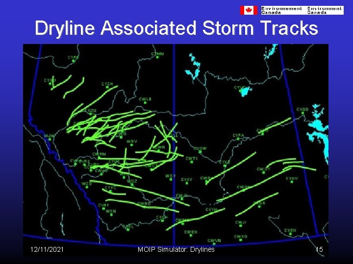
Dryline Associated Storm Tracks 12/11/2021 MOIP Simulator: Drylines 15
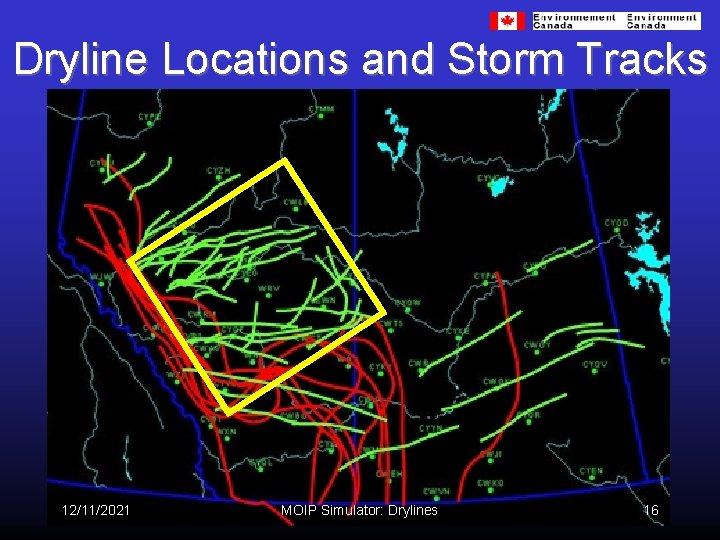
Dryline Locations and Storm Tracks 12/11/2021 MOIP Simulator: Drylines 16
Dryline Morphology • develops rapidly (<6 hours) parallel to foothills • evolution strongly linked to flow over mountains (~700 mb) Two Types: (depending on 700 mb flow) I: general 15 -20 kt SW flow over Rockies => QS II: 20 -30 kt 700 mb jet => bulges eastward • direction / extent of bulge function of location, angle, and speed of jet over mountain barrier 12/11/2021 MOIP Simulator: Drylines 17
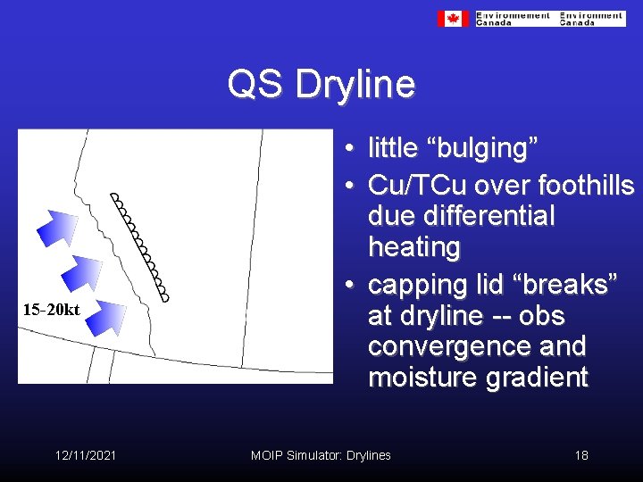
QS Dryline 15 -20 kt 12/11/2021 • little “bulging” • Cu/TCu over foothills due differential heating • capping lid “breaks” at dryline -- obs convergence and moisture gradient MOIP Simulator: Drylines 18
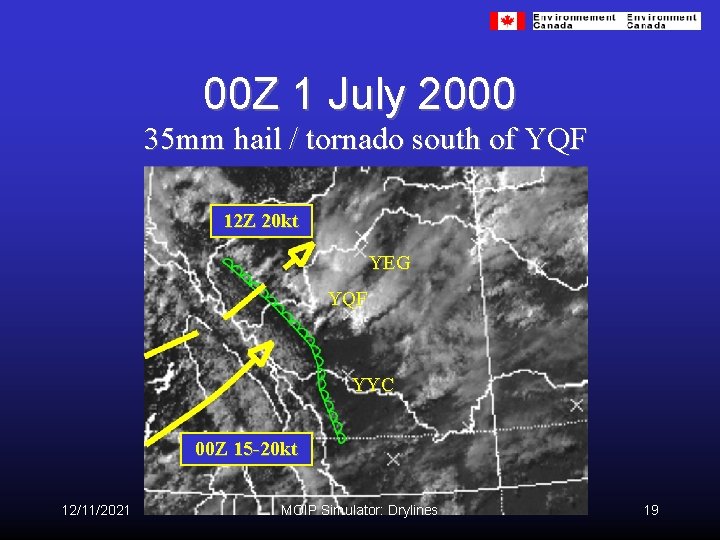
00 Z 1 July 2000 35 mm hail / tornado south of YQF 12 Z 20 kt YEG YQF YYC 00 Z 15 -20 kt 12/11/2021 MOIP Simulator: Drylines 19
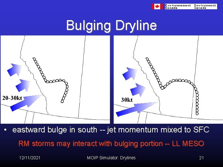
Bulging Dryline 20 -30 kt • eastward bulge in south -- jet momentum mixed to SFC RM storms may interact with bulging portion -- LL MESO 12/11/2021 MOIP Simulator: Drylines 21
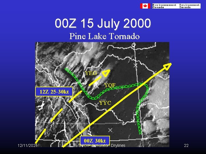
00 Z 15 July 2000 Pine Lake Tornado YEG YQF 12 Z 25 -30 kt YYC 12/11/2021 00 Z 30 kt MOIP Simulator: Drylines 22
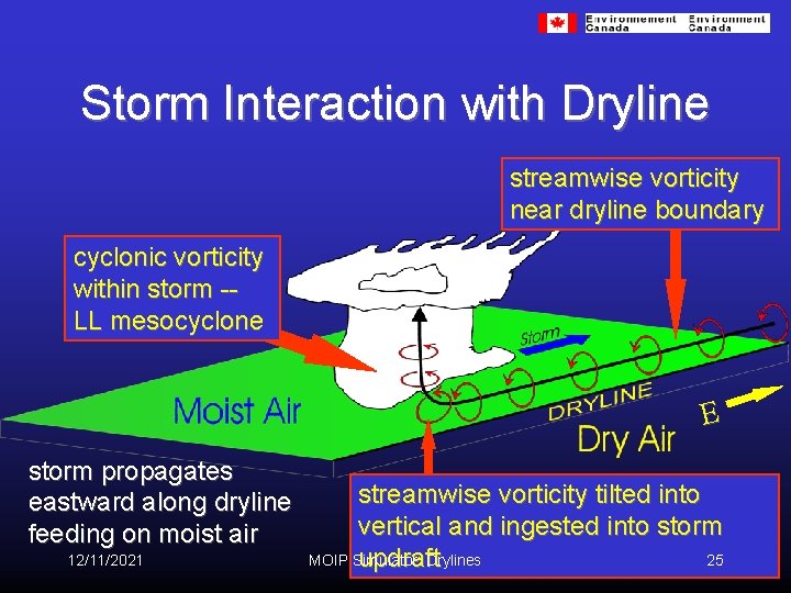
Storm Interaction with Dryline streamwise vorticity near dryline boundary cyclonic vorticity within storm -LL mesocyclone E storm propagates eastward along dryline feeding on moist air 12/11/2021 streamwise vorticity tilted into vertical and ingested into storm MOIP Simulator: Drylines 25 updraft
Forecast Issues • SW flow aloft (upper trough / low) • moisture gradient over foothills -- SFC isodrosotherms, mixing ratio, theta e/w • at least 15 -20 kt SW flow over mountains (700 mb) • monitor SFC winds / moisture SW Alberta -often develops by 18 Z • mid-level jet over mtns -- monitor dryline for bulge ( bulging can trigger storms in SW/W SK) • 12/11/2021 beware RM storms near E-W portion of bulge MOIP Simulator: Drylines 26
Summary • a significant feature for summer severe weather in Alberta (13 of 22 days from 2000) • develops mainly in response to subsidence in lee of mountains • synoptic scale => mesoscale => microscale • anticipate dryline development from 12 Z analysis (previous day? ) -- i. e. , forecastable • two types depending on 700 mb flow • RM storms can interact with bulging dryline -tornado 12/11/2021 MOIP Simulator: Drylines 27
Future Work • establish dryline climatology (threshold wind speeds, dewpoint gradients, time of convection, strength of cap…) • high-resolution mesoscale modeling of Alberta dryline • where’s the dryline? 100 km SFC obs. • obtain in-situ measurements of BL moisture and winds (mesonet, instrumented vehicle, soundings, etc. ) through UNSTABLE 12/11/2021 MOIP Simulator: Drylines 28
- Slides: 25