Future NCEP modeling plans Corey Guastini IMSG at


 GFS, MOM 4, NOAH, Sea Ice 3 D-VAR DA Current")
 Source: GFDL")


 Q 3 FY 18: Prototype a")


, 250 -h. Pa")
 Storm reports in Albany occurred around 19 Z 19 -h")


 HREFv 2 is the baseline against")

- Slides: 23
Future NCEP modeling plans Corey Guastini IMSG at NCEP/EMC and Geoff Manikin NCEP/EMC
Outline Timeline of NCEP’s transition to FV 3 dynamic core Overview of convection-allowing ensemble HREFv 2 and example forecasts
Proposed unification plan
Climate Forecast System (CFS) GFS, MOM 4, NOAH, Sea Ice 3 D-VAR DA Current complexity of NCEP model suite Regional Hurricane Waves Wave. Watch III NWPS GFDL WRF-NMM SURGE SLOSH Ecosystem Ew. E P-SURGE SLOSH Ocean 21 GFS Members Regional NAM NMMB NOAH Dispersion HYSPLIT Short-Range Ensemble Forecast Air Quality WRF(ARW, NMMB, NMM) North American Ensemble Forecast System GEFS, Canadian Global Model North American Land Surface Data Assimilation System NOAH Land Surface Model • Great Lakes (POM) • N Gulf of Mexico (FVCOM) • Columbia R. (SELFE) • Chesapeake (ROMS) • Tampa (ROMS) • Delaware (ROMS) • San Francisco (FVCOM) CMAQ High Res Windows WRF(ARW, NMMB) NEMS Aerosol Global Component (NGAC) GFS & GOCART Space Weather ENLIL 3 D-VAR DA Global Ensemble Forecast System (GEFS) ADCIRC Regional Bays Rapid Refresh 3 D-VAR DA Global Forecast System (GFS) Global Spectral NOAH ESTOFS 3 D-VAR DA 3 D-En-Var DA HYCOM High Resolution RR WRF ARW 4
Unification around Finite-Volume Dynamical Core on the Cubed-Sphere (FV 3) Source: GFDL
FV 3 -GFS Q 3 FY 18: Initial performance evaluation with beta release to field. Configuration similar to GFS Q 2 FY 19: Increase model resolution to approximately 9 km and 127 levels, implement advanced and scale-aware physics, perform retrospective and realtime evaluation of various configurations, conduct pre-implementation testing and evaluation, and prepare model for transition to operations in Q 3 FY 19
Advanced scale-aware physics Targeting improvements in microphysics, scale-aware convection, boundary layer and shallow convection treatment, stationary and non-stationary gravity wave drag, land surface model, and treatment of radiation
FV 3 -GEFS Q 3 FY 18: Determine ensemble configuration (e. g. , number of members, resolution, coupling to other earth-system components, extension of forecast from 16 to 35 days). Q 2 FY 19: Complete approximately 20 -year reanalysis using ESRL/PSD’s 20 -year atmospheric reanalysis project Q 3 FY 19: Complete approximately 20 -year reforecast Q 4 FY 19: Transition to operations
FV 3 -SFS (Seasonal Forecast System; renaming CFS) Q 3 FY 18: Prototype a 9 -month, coupled SFS Q 1 FY 20: Freeze system and begin 30 -year reanalysis and reforecast Q 1 FY 22: Operational implementation
Convection-allowing models
HREFv 2 CONUS membership -12 0 +12 +24 +36 Hires. W - ARW Hires. W - NMMB NAM CONUS NEST HIRESW - “mem 2” ARW similar to NSSL WRF 8 convection-allowing members with approximately 3 -km resolution Source: Matt Pyle 11
HRRR 18 Z 24 October 2017 analysis SLP (contours; h. Pa), 250 -h. Pa wind magnitude (fill; kt), and 10 -m, 850 -h. Pa, and 500 -h. Pa winds (barbs; kt) SLP (contours; h. Pa), 10 -m winds (barbs; kt), and 2 -m dew point (fill; F) 500 -h. Pa geopotential heights (contours; dam), winds (barbs; kt), and absolute vorticity (fill; 10− 5 s− 1) Surface-based CAPE (fill; J kg− 1) and CIN (hatched; J kg− 1)
Composite reflectivity (d. BZ) Storm reports in Albany occurred around 19 Z 19 -h HREFv 2 forecasts Marginal severe threat, but highest updraft-helicity probabilities correspond with severe reports
36 -h HREFv 2 precipitation Arithmetic mean Probability matched mean Average of arithmetic and probability matched
May 18 Upstate NY Observed radar loop Source: Mike Evans
00 Z HREFv 2 probabilities valid 21 Z Source: Mike Evans
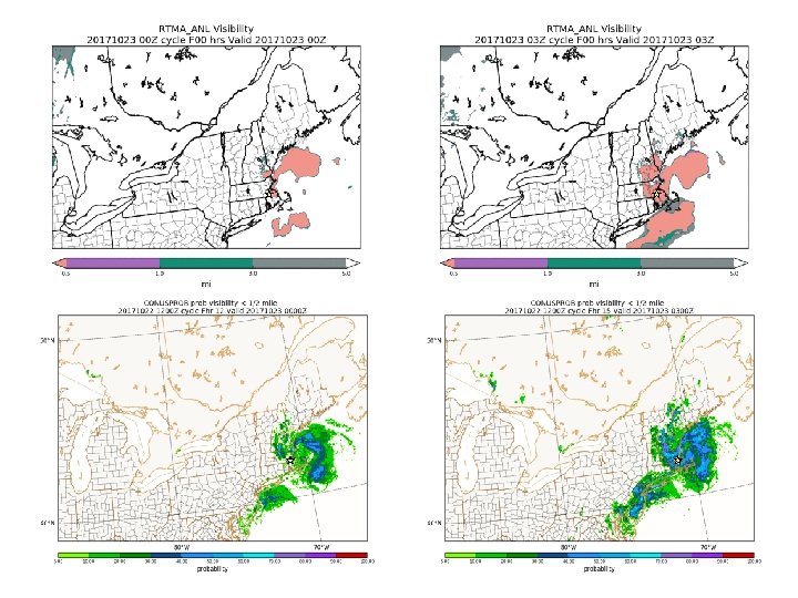
Fog in Foxborough, Massachusetts 22 October 2017 Charles Krupa/AP Photo
14 March 2017 snowstorm Snowfall gradient across Long Island New Jersey
PROB SN PROB IP MARCH 14 STORM HREFv 2 sniffs out ZR threat in DCA-BWIILG corridor and mix into PHL PROB ZR Source: Geoff Manikin
PROB SN PROB IP HREFv 2 shows that DCA-PHL corridor will not remain all snow; lesser hint for NYC PROB ZR Source: Geoff Manikin
Future HREF (will become Rapid Refresh Forecast System) HREFv 2 is the baseline against which other ensemble systems up for consideration will be tested Rapid Refresh Forecast System (RRFS): Single core, FV 3, convection-allowing ensemble running hourly. Some runs to 18 hours, some to 36, some to 72 FY 18: Test FV 3 at CAM resolutions with CAM physics. Prototype ensemble DA FY 19: Choose FV 3 configuration for Rapid Refresh Forecast System (RRFS), continue developing ensemble DA and CAM physics. Implement next version of HREF with added FV 3 and HRRRv 3 members FY 20: HRRRv 4 implemented with ensemble DA. All ARW development ends with HRRRv 4 implementation. Create initial FV 3 CAM ensemble forecasts for RRFS FY 21: Year of preparation for RRFS implementation (e. g. , getting all products in place and finalizing ensemble size) FY 22: Operational implementation of RRFS
Summary Exciting time at NCEP as we aim to decrease production suite complexity while increasing skill from seasonal to hourly forecasting