Freshwater The Water Cycle Topographic Maps Topography The


- Slides: 58
Freshwater
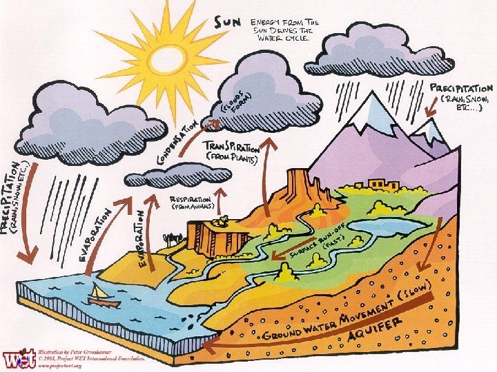
The Water Cycle
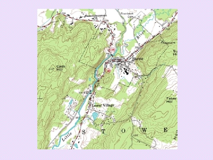
Topographic Maps • Topography – The surface features of the Earth – Determines where water will collect in streams, rivers, ponds, and lakes
Topographic Maps • A type of map which shows a region’s topography • Show both natural features, such as rivers and hills, and constructed features, such as roads and buildings
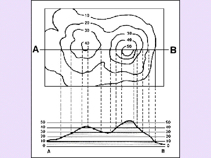
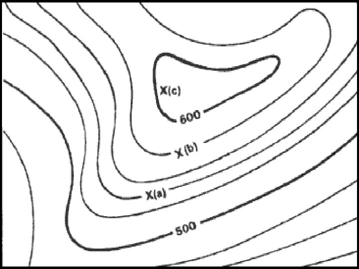
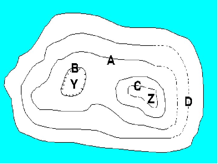
Topographic Maps • Contour Lines connect points on a map that have the same elevation compared to sea level • Contour Intervals refer to the change in elevation between one contour line and the next one
Topographic Maps • The spacing and direction of the contour lines will help you determine the shape of the land • The closer the lines, the steeper the slope • A V-shape usually indicates a stream or river, with the V pointing upstream • Contour lines with hash marks indicate a depression
Freshwater • If more precipitation falls than is absorbed by plants or the ground, runoff occurs. • The water collects in the lowest regions in either streams, rivers, ponds, or lakes.
Freshwater So what exactly is the difference between a pond a lake?
Freshwater A pond is just a small lake in which enough sunlight reaches the bottom to support plant growth
River Systems • A river system is made up of a main stream and all the feeder streams, called tributaries. • Watershed, or drainage basin, is the land where all runoff enters the same river system.
River Systems • Watersheds are separated by ridges or elevated regions of high ground called divides
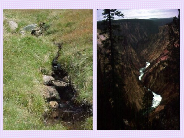
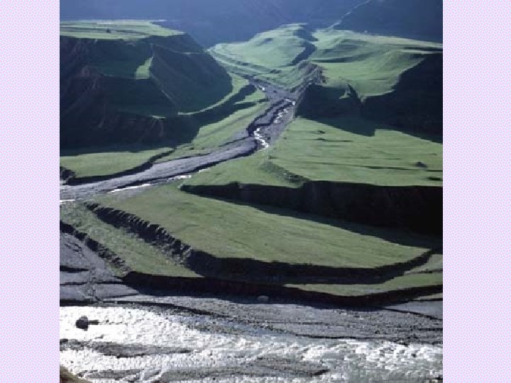
River Systems • As runoff moves across the land, it erodes the surface into a narrow ditch called a gully • Continued precipitation, erosion, and widening of the gully leads to a permanent stream
River Systems • Channel- the path that a stream follows • The stream carries more than just water as it flows- soil, loose rock, dissolved minerals • All of the materials carried by a steam are the stream load
River Systems • Suspended Load- fine sand silt that does not sink to the stream bed • Bed Load- coarse sand, gravel, and pebbles that grind at the stream bed as they are carried downstream • Dissolved Load- minerals that are dissolved in the water
River Systems • Erosion is also affected by a streams discharge and velocity • Discharge- the volume of water carried by a stream in a given amount of time • Velocity- the speed the water flows
River Systems • Velocity is affected by the topography • Gradient describes the steepness of the land’s slope – Near the headwaters, the gradient is steep – Near the mouth, the gradient is gentle
River Systems • Stages of a River – Youthful River • • Erodes stream bed more than the banks Steep V-shaped valleys Waterfalls and rapids are common Few tributaries
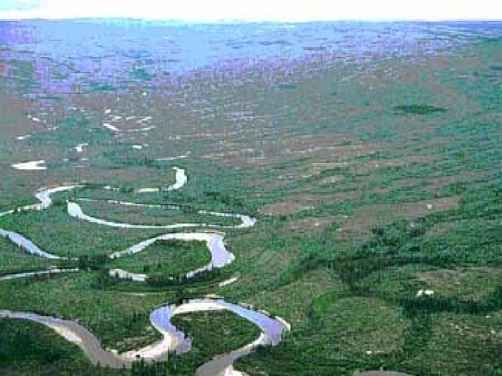
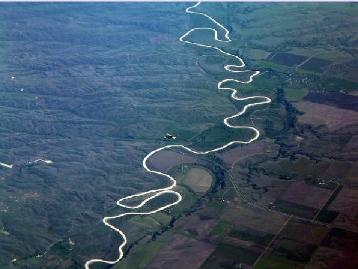
River Systems • Mature River – Many tributaries – Erosion occurs along banks – Wide, relatively flat valley – Meanders- curves formed as erosion takes place – Oxbow lakes can be formed as a meander straightens out
River Systems • Old Rivers – Low gradient – Flows slower than a mature river – Few, but rather large, tributaries – Less erosion
River Systems • Rejuvenated River – An old or mature river whose gradient has become steeper due to movement of the Earth’s crust – Step-like terraces are seen as the valley floor is uplifted and the river cuts through creating a new valley floor
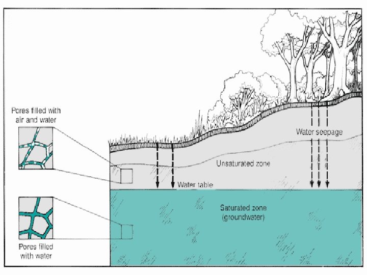
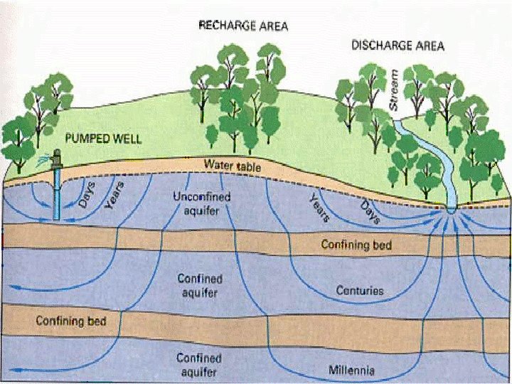
Groundwater • Precipitation that does not run off directly into streams will seep into the soil filling any air spaces between particles of rock and sediment. • This water found beneath the Earth’s surface is called groundwater.
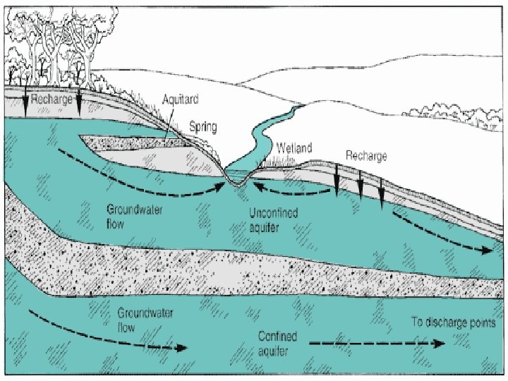
Groundwater • A body of rock which stores water is called an aquifer. • Regions with sediments such as sand gravel, sedimentary rock, or fractured rock can all be areas with large aquifers.
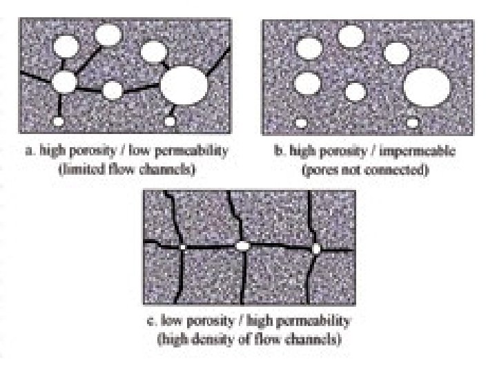
Groundwater • There are two main variables that help decide how much water can be stored by a particular type of rock. – Porosity – Permeability
Groundwater • Porosity – The percent of open spaces in the rock • Sorting- well sorted particles of rock will be similar in size and results in high porosity. Poorly sorted rock will have low porosity • Packing- Loosely packed particles will have plenty of pore space, tightly packed particles will have little or no pore space
Groundwater • Permeability – Permeability indicates how freely water passes through the open spaces in it – Rock made of large, poorly sorted particles is the most permeable – Large cracks will increase permeability – Rocks that prevent the flow of water are said to be impermeable
Groundwater • Zone of Saturation – Layer of the ground where all of the pores are filled with water • Water Table – The upper surface of the zone of saturation. This level may rise or fall.
Groundwater • Zone of Aeration – Layer of ground between the water table and the earth’s surface. • Upper portion near surface will be moist • Lower portion near water table will be moist • Middle region will normally be dry
Groundwater • As water is removed from an aquifer, new water must take its place in order to recharge the aquifer • This can be done either by rainfall or the movement of groundwater based on topography
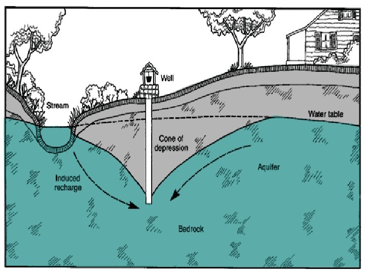
Groundwater • Ordinary Wells and Springs – A well is a hole dug below the water table that fills with groundwater. – A spring is a natural flow of groundwater to the earth’s surface that is found where a low spot in the ground is beneath the water table.
Groundwater • Groundwater can be pumped out of a well faster than it flows through the ground. This lowering of the water table near the well is called a cone of depression.
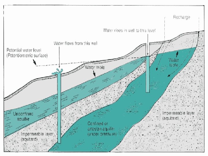
Groundwater • Artesian Wells and Springs – Wells and /or springs whose aquifer is located beneath a layer of impermeable rock called a cap rock. – Water is pushed to the surface by pressure so no pumping is required.
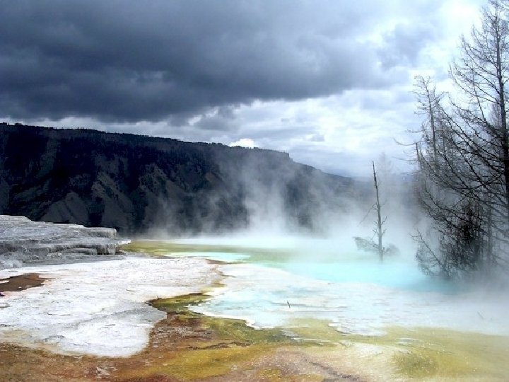
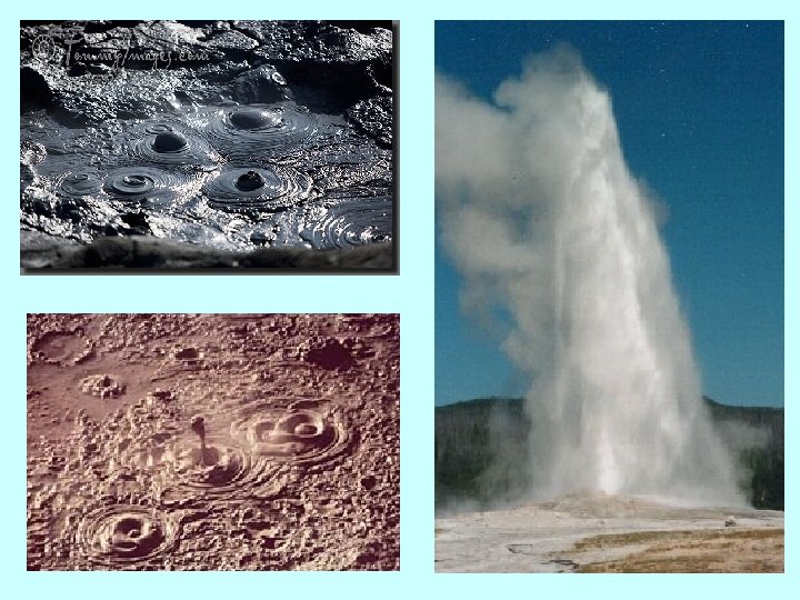
Groundwater • If groundwater is located in a region where magma is close to the surface, hot springs can be formed. • A hot spring must have water as warm as human body temperature (37˚C)
Groundwater • Hot springs can mix with the soil to form mud pots, areas of hot, thick, bubbling clay. • Hot springs that erupt above the surface are called geysers
Groundwater • As groundwater passes through permeable rock it dissolves some of the minerals that make up the rock. • Calcium, Magnesium, and Iron
Groundwater • Hard water has large amounts of dissolved minerals • Soft water has relatively few dissolved minerals • Hard water can affect soap suds, taste, and leave deposits.
Groundwater Hardness
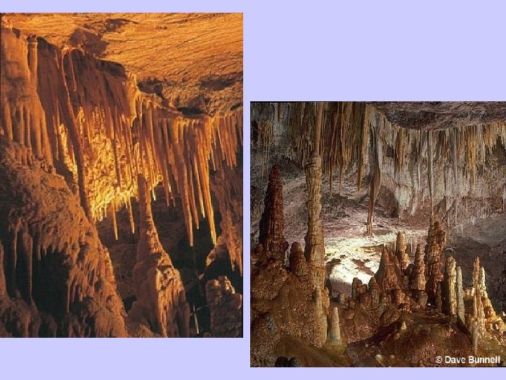
Groundwater • In certain sedimentary rocks such as limestone, groundwater erosion can create caverns. • As this water evaporates, the dissolved calcite solidifies forming stalactites and stalagmites
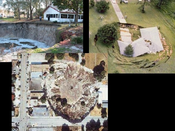
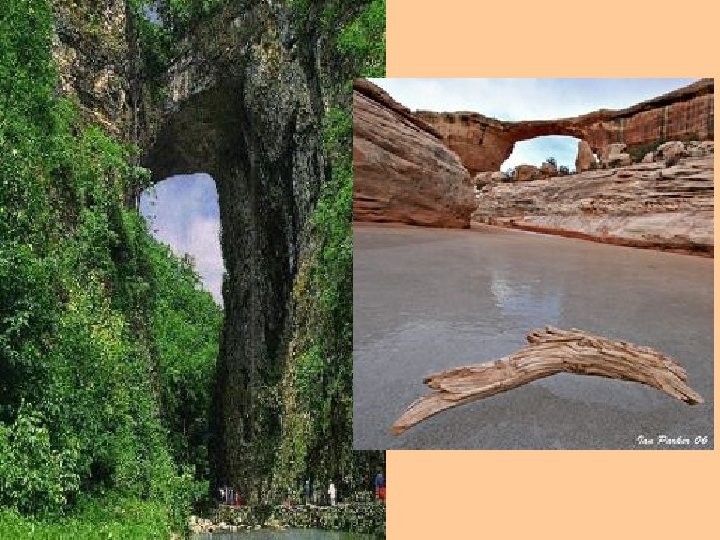
Groundwater • Caverns close to the surface may be prone to having the roof collapse forming a sinkhole • Sometimes a series of sinkholes occur that leave part of the roof of the cavern intact, this forms a natural bridge