Fresh Water All fresh water on Earth comes


– layers of rock and soil above the water")


- Slides: 16
Fresh Water
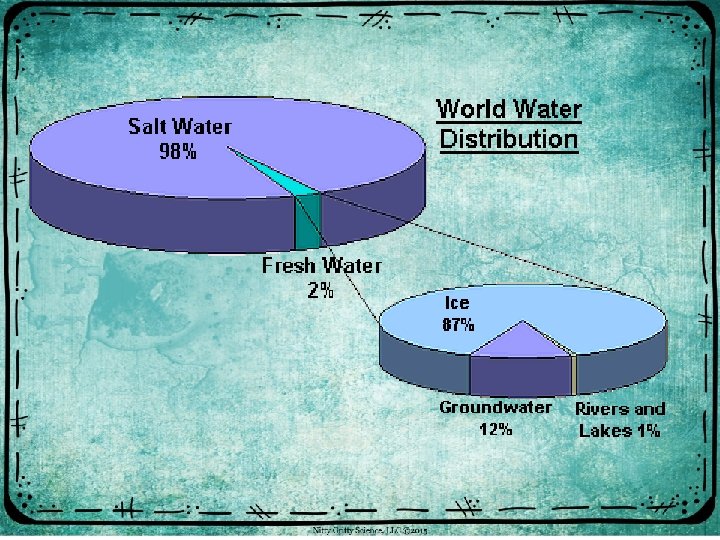
All fresh water on Earth comes from precipitation, some of which is evaporated immediately or soaks into the soil, the remaining water is runoff, or water that flows over the ground surface.
Glaciers Huge mass of ice and snow that moves slowly over land formed in areas where more snow falls each year than melts. • icebergs – broken, or glaciers that have calved into ocean
Groundwater Comes from precipitation that soaks into the ground between particles of soil and spaces in layers of rock. • saturated zone – area of permeable rock or soil that is totally filled, or saturated with water; • water table – top of saturated zone
Porosity The amount of groundwater that can be stored depends on porosity Porosity: the % of the total volume of rock or sediment that consists of pore spaces. • Groundwater moves by twisting and turning through these spaces • Groundwater moves more slowly when pores are smaller.
Different types of soil Which type of soil would have the greatest porosity? The least? SAND SILT PEBBLES CLAY
Groundwater Unsaturated zone (Zone of aeration)– layers of rock and soil above the water table that contain air as well as water, not able to be saturated • aquifer – layer of rock or sediment that holds water and can range in size from a small pond to an area of several states • Aquitard: Impermeable layers that get in the way or prevent water movement • well – man-made hole drilled below the water table in order to obtain groundwater from an aquifer
Artesian Well • A well, which water rises because of pressure within an aquifer
natural spring – place where groundwater bubbles or flows out of cracks in the rock geyser – type of hot spring which begins to rise through narrow passages being forced out by heated gases and steam from below
Ponds and lakes – form when water collects in hollows and low-lying areas of land Wetlands – area of land that is covered with a shallow layer of water during some or all of the year. Three common types are marshes, swamps and bogs • coastal wetlands usually contain a mixture of fresh and salt water, such as estuaries, salt marshes and mangrove forests
River System A river and all its tributaries, or small streams together with the watershed, the land area that supplies water to the system
Watershed A watershed is used to describe a smaller area of land that drains to a smaller stream, lake, or wetland
What are River Basins • River Basin – portion of land drained by a river and its tributaries (branches) • It includes all of the land surface dissected and drained by many streams and creeks that flow downhill into one another, and eventually into one river • Eventually empty into an estuary or ocean • There are 17 river basins in North Carolina • Drain 52, 337 square miles of surface and underground water • We ALL live in a river basin
What are the similarities and differences between a river basin and watershed? Both river basins and watersheds areas of land that drain to a particular water body, such as a lake, stream, river or estuary. In a river basin, all the water drains to a large river. The term watershed is used to describe a smaller area of land that drains to a smaller stream, lake or wetland. There are many smaller watersheds within a river basin .
Your assignment: • River Basin Graphic • You are a topographer trying to help people become more interested in the river basin that they live in. You are going to create a brochure of the river basin assigned to you that includes all the information below. • Go to http: //www. ee. enr. state. nc. us/riverbasinsinteractive. html. The map is interactive so click on your river basin and it will bring up an article that includes all the information that you will need to provide on your brochure. • You will create a poster or infographic using piktochart. com. Sign on using your school google account. The format is up to you as long as you cover the following information in a logical and easy to read way.