frente do nosso tempo National Strategy for Weather


- Slides: 30

à frente do nosso tempo National Strategy for Weather Monitoring and Forecast Vanda Costa MONITORIZAMOS O TEMPO O CLIMA A ACTIVIDADE SÍSMICA CONTRIBUÍMOS PARA UM MUNDO MAIS SEGURO e UM DESENVOLVIMENTO SUSTENTÁVEL

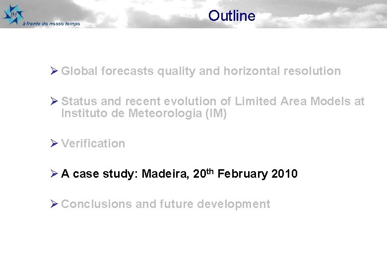
à frente do nosso tempo Outline Ø Global forecasts quality and horizontal resolution Ø Status and recent evolution of Limited Area Models at Instituto de Meteorologia (IM) Ø Verification Ø A case study: Madeira, 20 th February 2010 Ø Conclusions and future development

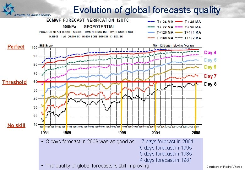
Evolution of global forecasts quality à frente do nosso tempo Perfect Day 4 Day 5 Day 6 Day 7 Threshold Day 8 No skill 1981 1985 1995 2001 2008 • 8 days forecast in 2008 was good(SS) as: 7 days forecast in 2001 Skillas Score days forecast in 1995 Measures the quality of the forecast relative 6 to a reference forecast 5 days forecast in 1985 (climatology or persistence) days forecast in 1981 (0 – No improvement over the 4 reference, • The quality global score, forecasts is –still improving 1 –ofperfect 0. 60 forecast skill threshold) Courtesy of Pedro Viterbo

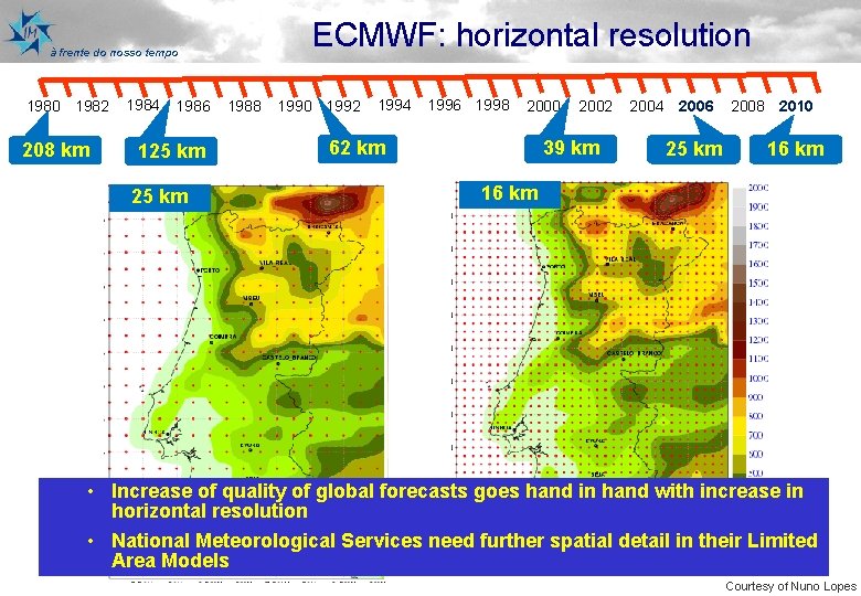
ECMWF: horizontal resolution à frente do nosso tempo 1980 1982 208 km 1984 1986 125 km 1988 1990 1992 1994 1996 1998 2000 62 km 2002 39 km 2004 2006 25 km 2008 2010 16 km • Increase of quality of global forecasts goes hand in hand with increase in horizontal resolution • National Meteorological Services need further spatial detail in their Limited Area Models Courtesy of Nuno Lopes

à frente do nosso tempo Outline Ø Global forecasts quality and horizontal resolution Ø Status and recent evolution of Limited Area Models at Instituto de Meteorologia (IM) Ø Verification Ø A case study: Madeira, 20 th February 2010 Ø Conclusions Ø Future development

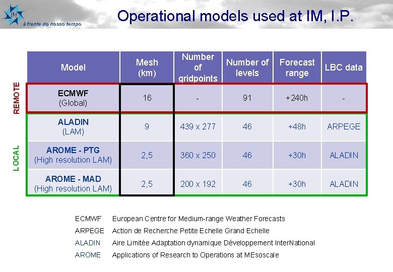
LOCAL REMOTE à frente do nosso tempo Operational models used at IM, I. P. Number of of levels gridpoints Model Mesh (km) Forecast range LBC data ECMWF (Global) 16 - 91 +240 h - ALADIN (LAM) 9 439 x 277 46 +48 h ARPEGE AROME - PTG (High resolution LAM) 2, 5 360 x 250 46 +30 h ALADIN AROME - MAD (High resolution LAM) 2, 5 200 x 192 46 +30 h ALADIN ECMWF European Centre for Medium-range Weather Forecasts ARPEGE Action de Recherche Petite Echelle Grand Echelle ALADIN Aire Limitée Adaptation dynamique Développement Inter. National AROME Applications of Research to Operations at MEsoscale

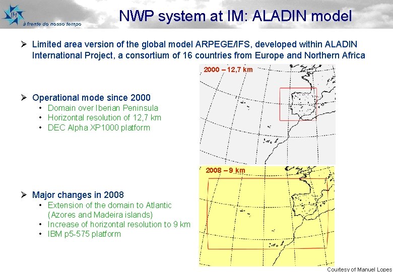
à frente do nosso tempo NWP system at IM: ALADIN model Ø Limited area version of the global model ARPEGE/IFS, developed within ALADIN International Project, a consortium of 16 countries from Europe and Northern Africa 2000 – 12, 7 km Ø Operational mode since 2000 • Domain over Iberian Peninsula • Horizontal resolution of 12, 7 km • DEC Alpha XP 1000 platform 2008 – 9 km Ø Major changes in 2008 • Extension of the domain to Atlantic (Azores and Madeira islands) • Increase of horizontal resolution to 9 km • IBM p 5 -575 platform Courtesy of Manuel Lopes

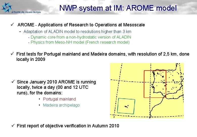
à frente do nosso tempo NWP system at IM: AROME model ü AROME - Applications of Research to Operations at Mesoscale - Adaptation of ALADIN model to resolutions higher than 3 km - Dynamic core from a non-hydrostatic version of ALADIN - Physics from Meso-NH model (French research model) ü First tests for Portugal mainland Madeira domains, with resolution of 2, 5 km, done locally in 2009 ü Since January 2010 AROME is running locally, twice a day (00 and 12 UTC runs), for the domains: • Portugal mainland • Madeira archipelago ü First report of objective verification in Autumn 2010

à frente do nosso tempo Outline Ø Global forecasts quality and horizontal resolution Ø Status and recent evolution of Limited Area Models at Instituto de Meteorologia (IM) Ø Verification Ø A case study: Madeira, 20 th February 2010 Ø Conclusions and future development

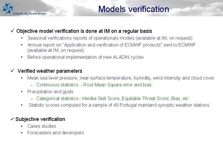
à frente do nosso tempo Models verification 6, 66 ü Objective model verification is done at IM on a regular basis • • • Seasonal verifications reports of operationals models (available at IM, on request) Annual report on “Application and verification of ECMWF products” sent to ECMWF (available at IM, on request) Before operational implementation of new ALADIN cycles ü Verified weather parameters • • • Mean sea level pressure, near-surface temperature, humidity, wind intensity and cloud cover - Continuous statistics - Root Mean Square error and bias Precipitation and gusts - Categorical statistics - Heidke Skill Score, Equitable Threat Score, Bias, etc Statistic scores computed for a sample of 48 Portugal mainland synoptic weather stations ü Subjective verification • Cases studies • Forecasters and developers

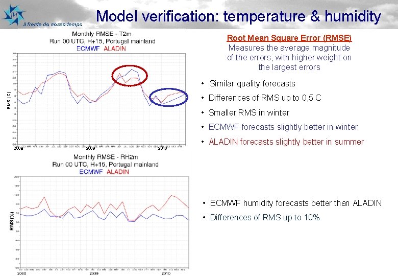
Model verification: temperature & humidity à frente do nosso tempo Root Mean Square Error (RMSE) Measures the average magnitude of the errors, with higher weight on the largest errors RMS (C) • Similar quality forecasts • Differences of RMS up to 0, 5 C • Smaller RMS in winter • ECMWF forecasts slightly better in winter 2008 2009 2010 • ALADIN forecasts slightly better in summer • ECMWF humidity forecasts better than ALADIN • Differences of RMS up to 10%

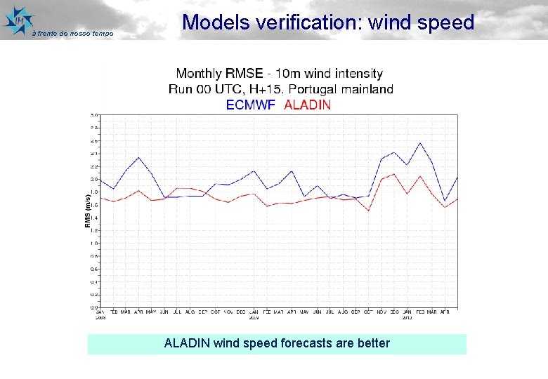
à frente do nosso tempo Models verification: wind speed ALADIN wind speed forecasts are better

à frente do nosso tempo Outline Ø Global forecasts quality and horizontal resolution Ø Status and recent evolution of Limited Area Models at Instituto de Meteorologia (IM) Ø Verification Ø A case study: Madeira, 20 th February 2010 Ø Conclusions and future development

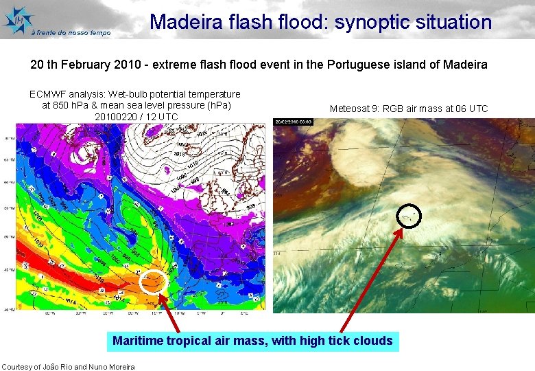
Madeira flash flood: synoptic situation à frente do nosso tempo 20 th February 2010 - extreme flash flood event in the Portuguese island of Madeira ECMWF analysis: Wet-bulb potential temperature at 850 h. Pa & mean sea level pressure (h. Pa) 20100220 / 12 UTC Meteosat 9: RGB air mass at 06 UTC Maritime tropical air mass, with high tick clouds Courtesy of João Rio and Nuno Moreira

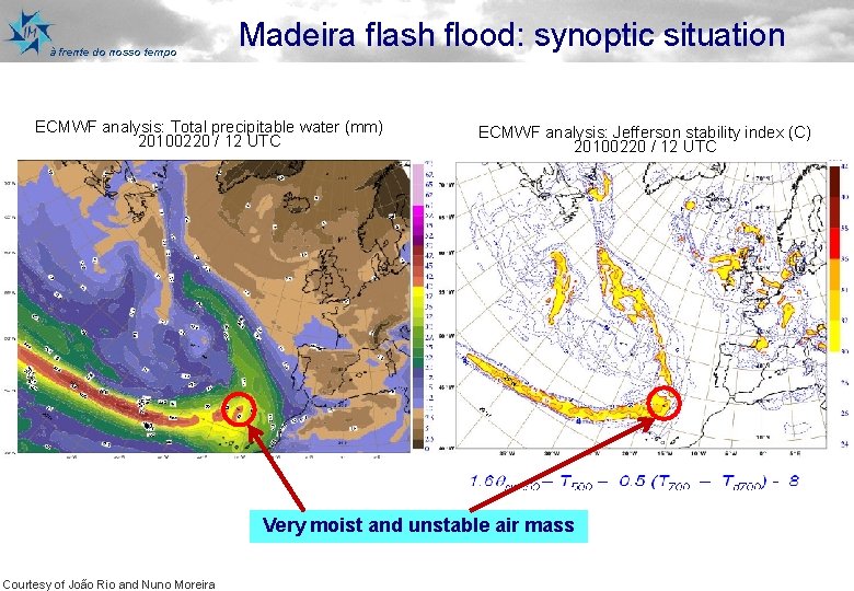
à frente do nosso tempo Madeira flash flood: synoptic situation ECMWF analysis: Total precipitable water (mm) 20100220 / 12 UTC ECMWF analysis: Jefferson stability index (C) 20100220 / 12 UTC Very moist and unstable air mass Courtesy of João Rio and Nuno Moreira

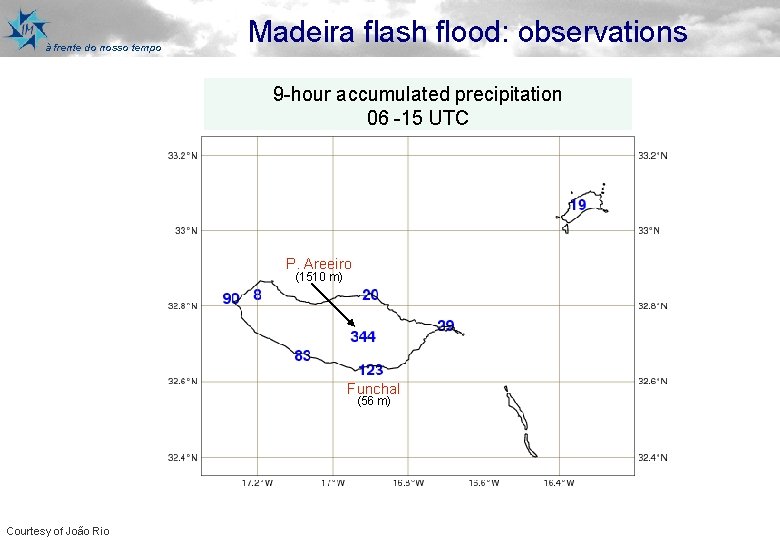
à frente do nosso tempo Madeira flash flood: observations 9 -hour accumulated precipitation 06 -15 UTC P. Areeiro (1510 m) Funchal (56 m) Courtesy of João Rio

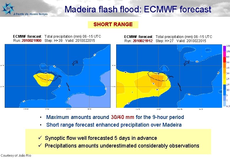
à frente do nosso tempo Madeira flash flood: ECMWF forecast SHORT RANGE ECMWF forecast: Total precipitation (mm) 06 -15 UTC Run: 2010021900 Step: H+39 Valid: 2010022015 ECMWF forecast: Total precipitation (mm) 06 -15 UTC Run: 2010021912 Step: H+27 Valid: 2010022015 • Maximum amounts around 30/40 mm for the 9 -hour period • Short range forecast enhanced precipitation over Madeira ü Synoptic flow well forecasted 5 days in advance ü Precipitations amounts underestimated considerably observations Courtesy of João Rio

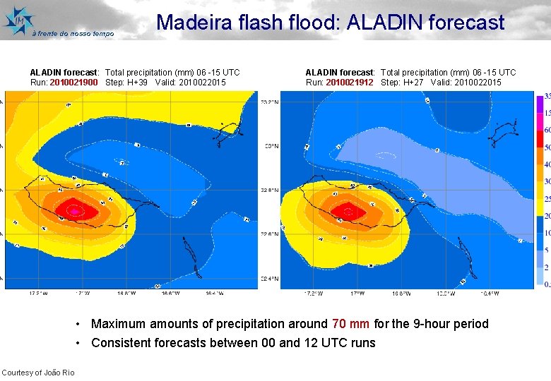
à frente do nosso tempo Madeira flash flood: ALADIN forecast: Total precipitation (mm) 06 -15 UTC Run: 2010021900 Step: H+39 Valid: 2010022015 ALADIN forecast: Total precipitation (mm) 06 -15 UTC Run: 2010021912 Step: H+27 Valid: 2010022015 • Maximum amounts of precipitation around 70 mm for the 9 -hour period • Consistent forecasts between 00 and 12 UTC runs Courtesy of João Rio

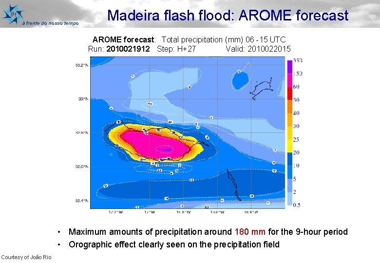
à frente do nosso tempo Madeira flash flood: AROME forecast: Total precipitation (mm) 06 -15 UTC Run: 2010021912 Step: H+27 Valid: 2010022015 • Maximum amounts of precipitation around 180 mm for the 9 -hour period • Orographic effect clearly seen on the precipitation field Courtesy of João Rio

à frente do nosso tempo Outline Ø Global forecasts quality and horizontal resolution Ø Status and recent evolution of Limited Area Models at Instituto de Meteorologia (IM) Ø Verification Ø A case study: Madeira, 20 th February 2010 Ø Conclusions and future development

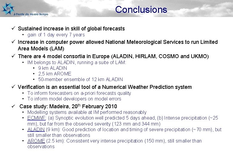
à frente do nosso tempo Conclusions ü Sustained increase in skill of global forecasts • gain of 1 day every 7 years ü Increase in computer power allowed National Meteorological Services to run Limited Area Models (LAM) ü There are 4 model consortia in Europe (ALADIN, HIRLAM, COSMO and UKMO) • IM belongs to ALADIN, running a suite of LAM: • 9 km ALADIN • 2, 5 km AROME • 50 -member ensemble of 12 km ALADIN ü Verification is an essential tool of a Numerical Weather Prediction system • To inform forecasters on a-priori forecasts quality • To inform model developers on model errors ü Case study: Madeira, 20 th February 2010 • Modelling systems available at IM performed reasonably • ECMWF: (a) Synoptic evolution well predicted 5 days ahead, (b) Intense precipitation (~25 mm), but far from the observed severity (123 mm and 344 mm) • ALADIN (9 km): Good prediction of location and timing of severe precipitation (~70 mm), but still smaller than observations • AROME (2. 5 km): Consistent very intense precipitation (150 mm), still smaller than observations

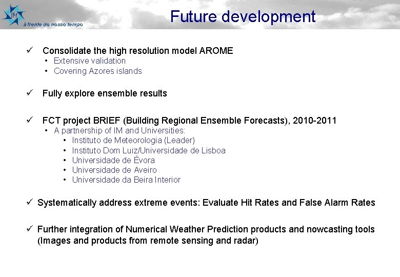
à frente do nosso tempo Future development ü Consolidate the high resolution model AROME • Extensive validation • Covering Azores islands ü Fully explore ensemble results ü FCT project BRIEF (Building Regional Ensemble Forecasts), 2010 -2011 • A partnership of IM and Universities: • Instituto de Meteorologia (Leader) • Instituto Dom Luiz/Universidade de Lisboa • Universidade de Évora • Universidade de Aveiro • Universidade da Beira Interior ü Systematically address extreme events: Evaluate Hit Rates and False Alarm Rates ü Further integration of Numerical Weather Prediction products and nowcasting tools (Images and products from remote sensing and radar)

à frente do nosso tempo Thank you for your attention MONITORIZAMOS O TEMPO O CLIMA A ACTIVIDADE SÍSMICA CONTRIBUÍMOS PARA UM MUNDO MAIS SEGURO e UM DESENVOLVIMENTO SUSTENTÁVEL

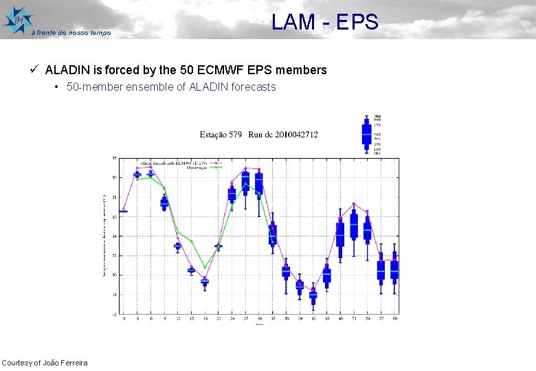
à frente do nosso tempo LAM - EPS ü ALADIN is forced by the 50 ECMWF EPS members • 50 -member ensemble of ALADIN forecasts Courtesy of João Ferreira

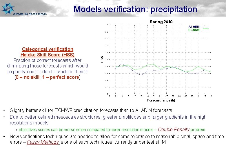
à frente do nosso tempo Models verification: precipitation Spring 2010 Categorical verification Heidke Skill Score (HSS) Fraction of correct forecasts after eliminating those forecasts which would be purely correct due to random chance (0 – no skill; 1 – perfect score) HSS ALADIN ECMWF Forecast range (h) • • • Slightly better skill for ECMWF precipitation forecasts than to ALADIN forecasts Due to better defined mesoscales structures, greater amplitudes and larger gradients in the high resolutions models è objectives scores can be worse when compared to lower resolution models – Double Penalty problem New verifications techniques are needed to allow for some tolerance to reasonable small space and time errors – Fuzzy Methods is one of such techniques, currently under test at IM

à frente do nosso tempo LAM - EPS ü 50 -member ensemble are calibrated • Model corrected = model forecast – model bias • Model bias = Model climatology – observations climatology ü Model climatology obtained averaging 360 members of the LAM-EPS • Every Thursday, LAM-EPS is forced by the 4 members of ECMWF ensemble forecast hindcast system, for the last 18 years • Model climatology can be obtained averaging the 72 members (4 x 18) • However, using a 5 week moving window, the model climatology can be obtained averaging 360 members (72 x 5) ü Observations climatology obtained averaging, for the same 5 week period, 18 x 5 = 90 members Courtesy of João Ferreira

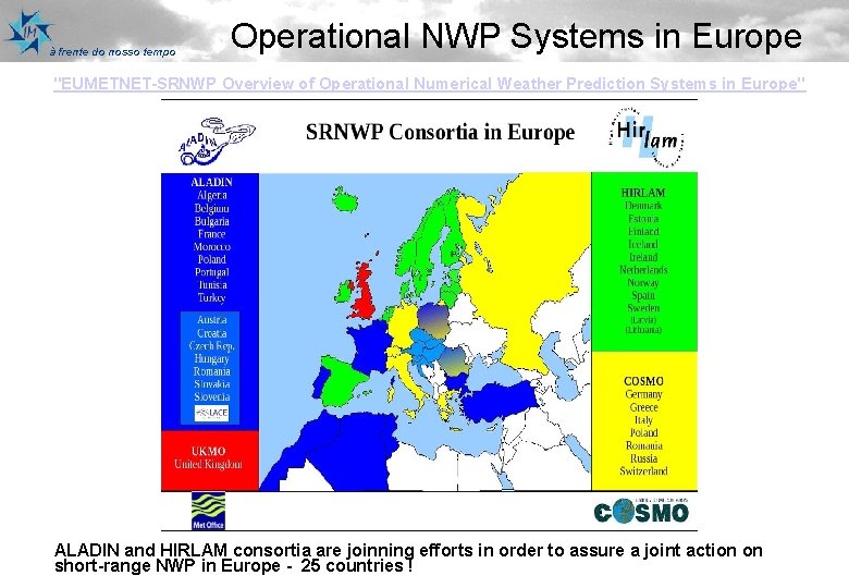
à frente do nosso tempo Operational NWP Systems in Europe "EUMETNET-SRNWP Overview of Operational Numerical Weather Prediction Systems in Europe" ALADIN and HIRLAM consortia are joinning efforts in order to assure a joint action on short-range NWP in Europe - 25 countries !

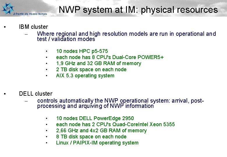
à frente do nosso tempo • IBM cluster – Where regional and high resolution models are run in operational and test / validation modes • • • NWP system at IM: physical resources 10 nodes HPC p 5 -575 each node has 8 CPU's Dual-Core POWER 5+ 1, 9 GHz and 32 GB RAM of memory 2 TB disk space on each node AIX 5. 3 operating system DELL cluster – controls automatically the NWP operational system: arrival, postprocessing and arquiving of NWP information • • • 10 nodes DELL Power. Edge 2950 each node has 2 CPU's Quad-Core. Intel Xeon 5355 2, 66 GHz and 4 x 2 GB RAM of memory 8 TB disk space on each node Linux / PAIPIX-IM operating system

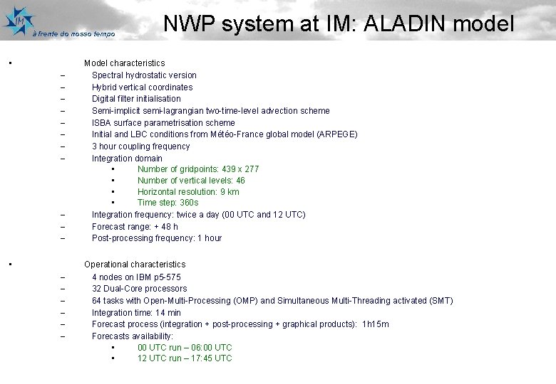
à frente do nosso tempo • – – – • – – – NWP system at IM: ALADIN model Model characteristics Spectral hydrostatic version Hybrid vertical coordinates Digital filter initialisation Semi-implicit semi-lagrangian two-time-level advection scheme ISBA surface parametrisation scheme Initial and LBC conditions from Météo-France global model (ARPEGE) 3 hour coupling frequency Integration domain • Number of gridpoints: 439 x 277 • Number of vertical levels: 46 • Horizontal resolution: 9 km • Time step: 360 s Integration frequency: twice a day (00 UTC and 12 UTC) Forecast range: + 48 h Post-processing frequency: 1 hour Operational characteristics 4 nodes on IBM p 5 -575 32 Dual-Core processors 64 tasks with Open-Multi-Processing (OMP) and Simultaneous Multi-Threading activated (SMT) Integration time: 14 min Forecast process (integration + post-processing + graphical products): 1 h 15 m Forecasts availability: • 00 UTC run – 06: 00 UTC • 12 UTC run – 17: 45 UTC

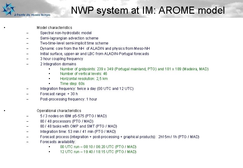
à frente do nosso tempo • – – – – – • – – – NWP system at IM: AROME model Model characteristics Spectral non-hydrostatic model Semi-lagrangian advection scheme Two-time-level semi-implicit time scheme Dynamic core from the NH of ALADIN and physics from Meso-NH Initial surface, upper-air and LBC from ALADIN-Portugal forecasts 3 hour coupling frequency 2 Integration domains • Number of gridpoints: 239 x 349 (Portugal mainland, PTG) and 181 x 189 (Madeira, MAD) • Number of vertical levels: 46 • Horizontal resolution: 2, 5 km • Time step: 60 s Integration frequency: twice a day (00 UTC and 12 UTC) Forecast range: + 30 h Post-processing frequency: 1 hour Operational characteristics 5 / 3 nodes on IBM p 5 -575 (PTG / MAD) 80 / 48 processors (PTG / MAD) 80 / 48 tasks with OMP and SMT (PTG / MAD) Integration time: 53 min / 41 min (PTG / MAD) Forecast process (integration + post-processing + graphical products): 2 h 15 m / 1 h (PTG / MAD) Forecasts availability: • 00 UTC run – 08: 10 / 06: 20 UTC (PTG / MAD) • 12 UTC run – 19: 40 / 18: 15 UTC (PTG / MAD)