Four Level Map Analysis How to complete a


: • Level 1 –")


? Consider this map of average of")


")
")
- Slides: 28
Four Level Map Analysis
How to complete a Four Level Map Analysis (4 LMA): • Level 1 – What am I looking at? Where? When? Scale? – What am I looking at? The best clue for Level 1 is the title, but also include any important identifying features of the map being analyzed (e. g. dates, map scale, type of map, # of classes) • Level 2 – Pattern Identification – What patterns do I see? List any patterns that you recognize. This is the spatial analysis, the heart and soul of thinking like a geographer. Don’t try to explain the patterns you see yet (That’s for level 3. ) • Level 3 – Plausible Explanations for Patterns – Why there? For each pattern identified in Level 2 write any plausible explanations you can think of for why that pattern exists (i. e. why that thing is where it is). • Level 4 – Okay…so what? – What surprised you? What will you remember? Why is this important? How does this affect me?
Geographer’s Questions Geographer’s Tools 1. WHERE TO LOOK? The Tool: Geographers identify Regionalization regions and consider (Chopping the world up how they came about. into defined regions. ) (This is the “Where? ” Related terms: location question of Human (site/situation), formal Geography) region, functional region, perceptual region.
Hmm…”Regionalization is to geography what periodization is to history. ” Alexander von Humboldt (1769 -1859)
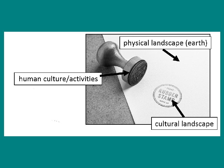
Geographer’s Questions 2. WHAT PATTERNS EXIST? Geographers use maps, remote sensing (satellites, aerial photographs, drones) to identify patterns of human activity. Geographer’s Tools The Tool: Spatial Analysis Related terms: distribution (density, concentration, and geometric pattern), cultural landscape
cultural landscape: the visible imprint of human culture and activities on the natural landscape.
(A small clue that cultural landscape may be a central theme in our course. )
Geographer’s Questions Geographer’s Tools 3. WHY ARE THESE The Tools: Diffusion PATTERNS THERE? Analysis, Models Geographers ask how Related terms: hearth, patterns of human diffusion (expansion, activity came to be. relocation, contagious, Why is (human activity and stimulus diffusion), X) where it is? ESPe. N
The Distance Decay Model is the most basic model in geography for explaining where things are. It is applied here applied to shopping habits.
Geographer’s Questions 4. WHAT CAN I LEARN BY JUMPING SCALES? Geographers Jump scales frequently because they know a phenomena they are studying at one scale may well be influenced by processes at other scales. Geographer’s Tools The Tool: Scale of Analysis (Jumping Scale) Related terms: cartographic scale, local, regional, national, and global scales of analysis
Why jump scales (view phenomenon at different scales)? Consider this map of average of first marriage. Look at India. What might you conclude?
Geographer’s Questions Geographer’s Tools 5. WHAT The Tool: Network INTERCONNECTIONS Analysis EXIST BETWEEN Can you think of any REGIONS? examples of Geographers identify and interconnections analyze ever changing between places that interconnections geographers might between places (how study? (Think of how events or processes in places connect and one place influence those interact with each in other places) other. )
Geographer’s Questions Geographer’s Tools 6. WHY CARE? The Tool: Heart! Geographers Use their (Compassion) conclusions to help solve real world Can you think of any real problems! world problems in the categories listed on your worksheet that geographers might help solve?
The Four Questions of Human Geography What is our subject? (religion, What? industry, cities…) Where is stuff? What patterns can Where? we observe? Why is stuff where it is? (How can Why There? we explain the patterns we see? ) How can we use what we’ve So What? learned to better understand solve real world problems?