Flood Inundation Mapping Techniques Using Satellite Imagery Irene


 Polar orbiting High resolution multi-spectral 13 bands Twin satellites")


- Slides: 23
Flood Inundation Mapping Techniques Using Satellite Imagery Irene Garousi-Nejad Term project of Remote Sensing of Land Surfaces April 25, 2017
Outline • Introduction to the problem • Methodology and data • Coding and results • Questions and Discussions
Introduction to the problem
Introduction to the problem During February 2017, a combination of widespread rainfall http: //kutv. com/news/local/2017 -flood-photos-from-box-eldercounty and snowmelt caused flooding along the northern Utah. http: //www. standard. net/Weather/2017/03/02/Flood-warningissued-in-Northern-Utah-with-worst-expected-in-Box-Elder-County
Introduction to the problem http: //www. prism. oregonstate. edu/comparisons/anomalies. php
Introduction to the problem http: //www. prism. oregonstate. edu/comparisons/anomalies. php
Introduction to the problem http: //www. prism. oregonstate. edu/comparisons/anomalies. php
Introduction to the problem https: //www. cbrfc. noaa. gov/
Introduction to the problem Box Elder County Willow Creek Malad River
Methodology and Data
Sentinel-2 Multi. Spectral Instrument (MSI) Polar orbiting High resolution multi-spectral 13 bands Twin satellites (180 degrees) Revisit frequency of 5 days Used in Emergency Management TOA Sentinel-1 Synthetic Aperture Radar (SAR) Carries and advanced radar All-weather, day-and-night ~ 5 m resolution in C band Twin satellites (180 degrees) Revisit frequency of 6 days Used in Emergency Management
Indices for detecting flooded area Sentinel-2 Calculating Normalized Difference Water Index Sentinel-1 Calculating the difference between wet and dry images
Coding and Results
GOOGLE EARTH ENGINE 1 - Import data 2 - Filter data for a specific time (February, 2017) and location (Box Elder County) 3 - Remove cloud effect and use cloud-free values 4 - Calculate NDWI 5 - Set the threshold 6 - Visualize the results
GOOGLE EARTH ENGINE 1 - Import data 2 - Filter data for a specific time (February, 2017) and location (Box Elder County)
GOOGLE EARTH ENGINE 3 - Remove cloud effect and use cloud-free values
GOOGLE EARTH ENGINE 4 - Calculate NDWI 5 - Set the threshold 6 - Visualize the results
GOOGLE EARTH ENGINE 1 - Import data 2 - Filter on a Location 3 - Create a map wet and dry conditions DRY
GOOGLE EARTH ENGINE 1 - Import data 2 - Filter on a Location 3 - Create a map wet and dry conditions WET
GOOGLE EARTH ENGINE 4 - Calculate the difference between wet and dry 5 - Determine a threshold WET-DRY
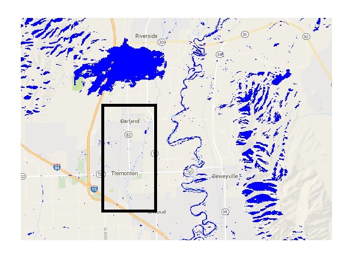
GOOGLE EARTH ENGINE 6 - Show the results The advantageous of sing Sentinel 1 (which carries SAR instrument) to detect water bodies is that measurements are not impeded by clouds.
Questions and Discussion Thank You