Flint Hills Smoke Management Plan May 9 2012


- Slides: 20
Flint Hills Smoke Management Plan May 9, 2012 NACAA Meeting Denver, Colorado om Gross ureau of Air ansas Department of Health and Environment
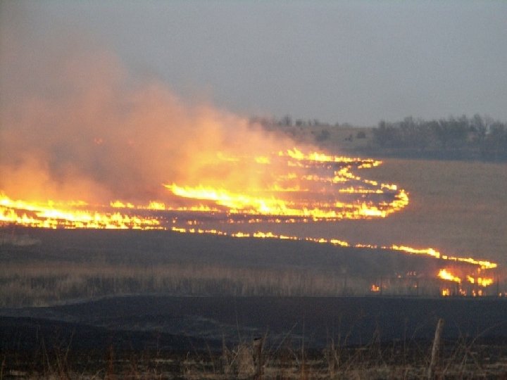
Flint Hills Burning Background Flint Hills is last large intact remnant of tall grass prairie ecosystem. 2 to 3 million acres are burned each spring in the Flint Hills. Burning helps reduce intrusion of invasive woody species and improves cattle weight gain. Land is privately held. Fires up to 10, 000 acres.
Flint Hills Burning Background Under certain weather patterns, smoke impacts downwind cities Smoke has caused exceedances of the ozone and PM NAAQS in KC, Wichita and far beyond. KDHE met with ag reps from 2004 through 2009 to negotiate solutions. Commitment to develop Smoke Management Plan in 2010. Multiple meetings with multiple stakeholders during 2010 to develop SMP. Plan adopted by KDHE in December 2010.
Safety Is a Primary Concern
The Smoke Management Plan Describes the Tall Grass Prairie ecosystem Reviews the balance between air quality concerns and the Flint Hills ag economy Is voluntary for prescribed burns of rangeland Includes restrictions on certain types of April burning Includes guidance and a modeling tool to assist land managers and fire officials in making burn decisions Spurred outreach activities by a host of state and federal agencies Included a voluntary burn data collection effort
Acres Burned in Flint Hills in April 2011 Manhattan KS OK Map generated using MODIS data downloaded from NASA website at https: //wist. echo. nasa. gov/api/ ENVI and Arc. GIS software used for image analysis. 2, 673, 000 Acres Burned
April 11, 2010 Fire and Smoke Plumes Our Vision – Healthy Kansans living in safe and sustainable environments.
Ks. Fire Website Modeling Home Page
Burn Guidance Tools Sonoma Technologies Inc. and KDHE developed tools to provide land managers daily information on when to burn to reduce air quality impacts. Web site: http: //www. ksfire. org Tools provide daily: • Burn guidance by county for the “next” two days • Forecast discussions • Extended outlooks • County-level burning scenario playground
April 5, 2011 Model Guidance • Maximum contribution to major cities based on cumulative impact from fires that could be ignited each day (e. g. , April 6 and 7, 2011) • County designated red, yellow or green based on county’s contribution • Uses forecasted meteorology and expected emissions for large burns
Example Guidance – Discussion Meteorologists provide additional information on possible smoke impacts and extended outlooks.
Example Guidance – Individual Plumes Provides hourly plume movement and concentration to assess a burn. Users enter: §County §Fire size §Fuel load Plume is brown Fire location is red Monitors are blue
Generating the Guidance � STI created a system that runs Blue. Sky with HYSPLIT each day to predict smoke plume movement and dispersion � Smoke plumes are derived from hypothetical burns � For individual plumes, burn characteristics are provided by users � For cumulative impact, burn characteristics are fixed � Smoke emission estimates are generated from Blue. Sky Framework � Weather inputs used by Blue. Sky are prepared from NCEP North American Model (NAM) 40 km forecast data Hypothetical fire locations The USDA Forest Service Blue. Sky Framework enables the use of stateof-the-science algorithms for simulating smoke impacts, air quality, and emissions from fires. HYSPLIT is the Hybrid Single-Particle Lagrangian Integrated Trajectory Model, developed by the National Oceanic and Atmospheric Administration’s Air Resources Laboratory.
Generating the Guidance �Hypothetical fires burn each day from 10 AM to 6 PM �Concentrations are tracked for 48 hours �For individual fires, hourly smoke plumes from each burn are mapped at 15 km resolution �For cumulative impact � 24 -hr surface PM concentrations from all fires are summed by grid cell � If contribution is large and downwind concentration is high in city of concern, then the county is colored
On Target
April 2011 Monitoring Results Current Ozone Standard = 75 ppb Date Location Pollutant Concentration April 6, 2011 Mine Creek Ozone 76 ppb April 6, 2011 Wichita - HD Ozone 79 ppb April 6, 2011 Wichita - Peck Ozone 82 ppb April 12, 2011 Konza Prairie Ozone 78 ppb* April 12, 2011 Topeka - KNI Ozone 84 ppb April 13, 2011 KC, Mo Ozone 76 ppb April 13, 2011 Konza Prairie Ozone 79 ppb* April 29, 2011 Peck Ozone 77 ppb *- CASTNET site that is not run by KDHE BOA
So……. What Now? April 2012 had least acres burned in decades. No exceedances of ozone or PM standards in 2012. Poor year to evaluate plan and model. Forecasting model improved for 2012 to Provide sub-county-level information Improve the display of individual plumes Provide information to help users determine fuel load Continue and expand outreach efforts. County officials, fire officials, more counties KDHE in final stages of completing 2011 exceptional event request.
Lessons Learned……. . Don’t Bite Off More Than You Can Chew!!!
QUESTIONS? Contact Information: Thomas Gross Bureau of Air 1000 SW Jackson, Suite 310 Topeka, Kansas 66612 (785) 296 -1692 tgross@kdheks. gov