Figure 1 Autonomous underwater gliders have been deployed

Figure 1 Autonomous underwater gliders have been deployed during hurricane season in the North Atlantic in support of hurricane research and operations since 2014. This effort is supported by the NOAA Integrated Ocean Observing System (IOOS), its regional associations and the University community. During Storm Isaias, there were a total of 23 underwater gliders deployed in the Caribbean, Gulf of Mexico, South and Mid-Atlantic Bight. Many of the gliders were on the path of Isaias (see Figure 1).
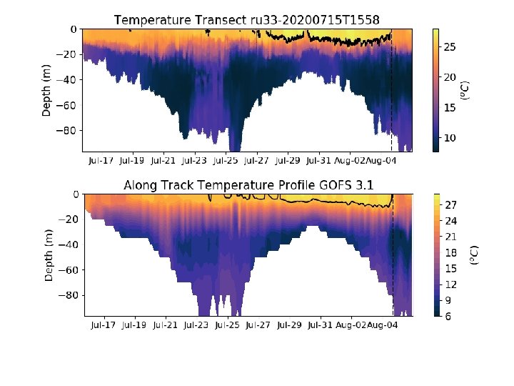

The glider data collected during hurricane season has two main goals: to consolidate our understanding of oceanatmosphere interactions during storms and to improve the hurricane forecast through the assimilation of glider data in numerical ocean models. These gliders collect temperature and salinity, among other quantities, as they travel up and down in the interior of the ocean in a sawtooth pattern. The temperature section shown in the upper figure is from glider RU 33 in the Mid-Atlantic Bight. The vertical dash line in the figure shows the time when Storm Isaias was the closest to RU 33. After the passage of the storm, we see that the surface temperature decreased from 28 o. C to 23 o. C. This drop in temperature is caused by vertical mixing of warm surface water with colder subsurface water, induced by the strong winds that we experienced during Isaias. This wind-induced cooling serves as a fire extinguisher for storms while remaining in contact with the ocean. The temperature section in the lower figure shows the same track as the one from RU 33, but extracted from the output of the Global Ocean Forecasting system (GOFS 3. 1), which is the operational ocean model run by the U. S. navy. This model provides the ocean initial conditions for the operational hurricane models run by NOAA. We see that GOFS 3. 1 captures the main features of RU 33 temperature transect, such as a warm surface layer and very cold subsurface layer before Isaias, as well as the vertical mixing caused by the storm. This is critical to provide the best ocean initial conditions to the hurricane forecasting models so they can accurately predict the intensity of hurricanes before landing and in this way, guide the response of coastal communities during potentially devastating storms.
- Slides: 3