Field measurements Preparation to field work Field observations

Field measurements • Preparation to field work • Field observations prior to any structural measurements • Measurements at the outcrop scale • Measurements on maps
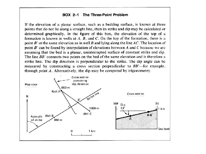
, by")
from The Earth - An Introduction to Physical Geology (2 nd ed. ), by Tarbuck & Lutgens, Merrill Publishing Co. , 1984) Grenerally topography reflect structures (because of differential erosion). This Provide clues about the orientation of structures (strike, dip) and guidance to help interpolating of extrapolating outcrop observations

Intersection with topography Intersection of planar structures with topography http: //www. uwgb. edu/dutchs/structge • Beds that are horizontal will have contacts at constant elevations. The contacts will coincide with or be parallel to topographic contours (above left). • When structures are vertical, a map view looks along the surface of the structure. Structures cross topography without deviating (above right). • Dipping planes fall somewhere in between these two extremes. The shallower the dip, the more the contacts follow contours. The steeper the dip, the less the influence of topography.

Determining strike and dip from geologic maps 75 m

-Topography slopes generally southeast and the contact dips northwest. -Topographic contours and structure contours on the contact are at 100 -meter intervals. The contact is in green and the rocks below the contact are in yellow. -The strike of the plane is 045 degrees and the location of the 700 -meter structure contour is the same. 1. Horizontal 2. Dip 9 NW 3. Dip 17 NW 4. Dip 32 NW http: //www. uwgb. edu/dutchs/structge

1. 2. 3. 4. http: //www. uwgb. edu/dutchs/structge Dip 52 NW Dip 68 NW Dip 79 NW (Contour Interval 100 and 200 meters) Dip Vertical

South Tianshan Piedmont erosional surface Courtesy of John Suppe

Hinge zone or axial surface at the front of Quilitak relief Courtesy of John Suppe

I. Basic Techniques in Structural Geology • • • Fundamental principles Field measurements and mapping Terminology on folds Stereographic projections Preparing maps and constructing crosssections • Seismic Imaging
.")
Folds tend to be cylindrical (an implication of rheological layering).

Fold terminology anticline Anticline: fold that has the older strata in the core and younger strata farther out (convex toward the younger strata). Syncline: Fold that has the younger strata in the core and older strata farther (convex toward the older strata) Note that Identifying an anticline or a syncline requires knowing the polarity of the stratigraphy. If the bed polarity is not known then use the terms Antiform: for a convex up fold. Synform: for a convex down fold. syncline

Fold terminology anticline synformal anticline syncline antiformal syncline

South Tian Shan Piedmomt, near Kuqa (Hubert-Ferrari et al, JGR, 2007; Daeron et al, JGR, 2007) The Quilitake Anticline

Fold terminology Folds come in three basic types: Folds can generally be subdivided in dip domains, and may have angular or curved fold hinge:

Fold terminology Dip domains are separated by axial surfaces, imaginary planes which viewed in two dimensions form axial traces. Anticlinal axial surfaces occupy concave-downward fold hinges; synclinal axial surfaces occupy concave-upward fold hinges. Anticlinal axial surface Synclinal axial surface

Fold terminology Axial surfaces often occur in pairs that bound fold limbs, which are also called kink bands:

Vertical axial surfaces: Symmetric folds
 Put here Quilitake core")
The Quilitak anticline (South Tianshan Piedmont) Put here Quilitake core

Fold terminology Symmetric upright http: //blank 005. tripod. com/geology/deformation. html Overturned Asymmetric Recumbent NB: Here the folds axis are all assumed horizontal
- Slides: 20