Feeling under the weather BIOWEATHER Pests locusts Parasites

“Feeling under the weather? ” BIOWEATHER Pests: locusts Parasites: worms, flukes and spirochetes Diseases: ‘emerging’ viruses

Locusts and grasshoppers in Africa
 in plant matter per")
Desert locusts Locusts eat their own weight (about 4 g) in plant matter per day; a swarm may consist of a billion insects, and 100 swarms may be on the move during a plague (eating 400 kilotons per day). A swarm can fly 300 km in one day, remain afloat out at sea (and take off again), and remain active even when covered by snow.

juvenile egg solitary hopper gregarious locust Source: BBC website
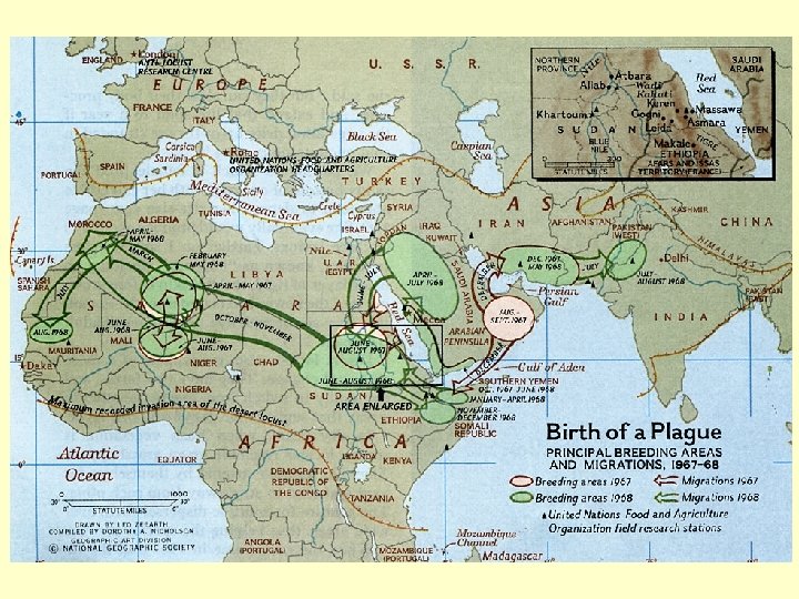
 Outbreak: 1967 -68. Drought in Africa in 1970’s")
Last major locust plague (1987 -89) Outbreak: 1967 -68. Drought in Africa in 1970’s and early 80’s produced a recession in the locust cycle. Heavy rains in 1987 -89. In Jan. 1987 large swarms formed in Saudi Arabia. Despite the Saudis’ massive control efforts some of the swarms crossed the Red Sea and gradually moved west to Mauritania and north to Algeria. Western Sahara had heavy rains, and threat to the states in North Africa was so grave that Morocco deployed 200 000 soldiers to combat the swarms. Strong winds aloft (associated with Hurricane Joan) carried some of these locusts across the Atlantic to the Caribbean in October 1988. They reached as far west as Jamaica.

Upsurges in 1990’s 1996 -1998: Local upsurge in Red Sea Basin (from Yemen - Saudi Arabia to Sudan - Ethiopia - Somalia -Eritrea)
 map of outbreak b) b) swarms")
a b Nov. CYPRUS, EGYPT 2004 outbreak a) map of outbreak b) b) swarms in Mauritania c) Aerial spraying in the western Sahara Source: BBC website c

Monthly snapshots of outbreaks from Nov. 2003 -Nov. 2004 gregarious adults gregarious juveniles

Rainfall and the Australian plague locust Scale of outbreak 2004 plague Sources: BBC website; www. affa. gov. au; www. bom. gov. au/silo/products/cli_chg

Combating locusts Good news: • Prediction of swarm development and movements much easier with satellites which can identify areas of new plant growth and wind patterns in remote desert areas. • Aerial spraying of young (pre-swarm) populations with insecticide (e. g. malathion) is still effective. • New biopesticide (Metarhizum fungus = “Green Muscle”) kills locusts and grasshoppers in 3 - 4 weeks. • Trigger for gregarious behaviour (hind leg stimulation!) recently identified; may lead to suppression techniques. • Locusts are more nutritious than beef - “Cooking with Sky Prawns” (20 recipes for cooking locusts from Australia)

Combating locusts Bad news: • Highly cyclical nature leads to poor maintenance of surveillance and control equipment during recessions. • Political conflicts create refuge areas for swarms: The western Sahara desert is littered with land mines from the Polisario war. Morocco-Algeria-Libya are reluctant to cooperate; The Sudan is currently in the midst of a civil war; locust control is not a priority for the local government or for international humanitarian agencies.
 Currently: ~3 000 M people at risk; ~50% of the")
Malaria (Ital: “bad air”) Currently: ~3 000 M people at risk; ~50% of the world’s population; 300 -500 M cases; ~80% in sub-Saharan Africa) Deaths: ~1 M annually Vector: transmitted by bites of female mosquitoes in the genus Anopheles (50 -60 of the >300 species), usually at night. Parasites: Four species of Plasmodium. P. falciparum causes the most severe symptoms. Symptoms: high fever, dehydration, death in severe cases

Global incidence of malaria Map area equivalent to cases per 100 people (92% of all cases in Africa) Source: www. worldmapper. org/posters/worldmapper_map 229_ver 5. pdf

Role of climate in malaria outbreaks Moisture: Breeding success of mosquitoes is maximized in nutrient-rich pools; populations are most abundant in wet weather. Too much rain, however flushes breeding pools and reduces mosquito populations. At temperatures between 25 -30°C the malarial parasites and mosquito larvae mature quickly, the adult mosquitoes live longer, and female mosquitoes feed more frequently. The transmission cycle is <30 days under these conditions.

Climate and malaria outbreaks Weekly malaria prevalence in Niger for the period 2001 -2003, and average monthly precipitation in the Sahel (thick blue line) rain >> pools >> evaporation >> nutrient enrichment >> mosquito breeding
 1934 -5 Malaria was hyperendemic in the dry north")
Malaria epidemic: Sri Lanka (Ceylon) 1934 -5 Malaria was hyperendemic in the dry north of island but rare in the wet south (heavy rains flush mosquito larvae away). Southern population had little natural immunity. Drought in 1934 -5 resulted in major epidemic in south. 30% of population fell ill; 80, 000 died. Illustrates Ross’s “math of malaria” (~25 d fever cycle) 1000 1500 cases 1000 100 >2000 1 Summer monsoon 0 25 50 75 days

Malaria resurgence …. . and decline 2005 -6 ~10 000 cases in South Africa 2006 -7 ~3 000 cases in South Africa
")
The demise of malaria in the USA (1882 -1946)

Why was malaria widespread in northern Europe in the LIA? Little Ice Age from: Reiter, P. 2000. "From Shakespeare to Defoe: Malaria in England during the Little Ice Age” Emerging Infectious Diseases vol. 6

Climate and viral disease Viral disease transmission Ecology of flavivirus outbreaks (e. g. dengue, West Nile encephalitis) Ecology of bunyavirus outbreaks (e. g. sin nombre)

Emerging viruses Family Disease Vector and Reservoir


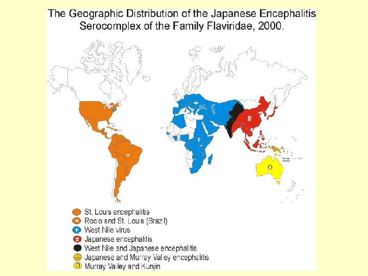
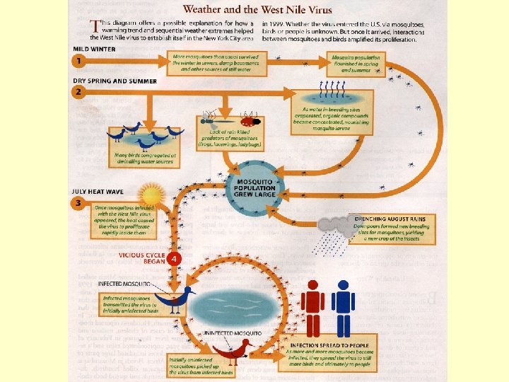
West Nile virus • West Nile virus is a strain of flavivrus, closely related to Japanese encephalitis. Previously reported from Africa and adjacent areas of southern Europe and western Asia. Previous outbreaks in Israel, France and S. Africa. and Romania (1996; 450 cases, 39 deaths). • It joins at least four other encephalitis viruses in North America, one of which [St. Louis encephalitis] is widespread. • Likely introduced into N. America by an infected international traveler or as a result of the importation of exotic birds.
 direct transmission?")
fever, aches, stupor, (brain lesions, coma, paralysis, death? ) direct transmission?

1999 to 2001
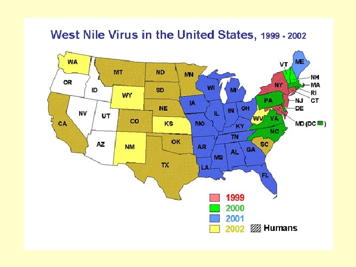

November, 2003 Total number of cases by state November, 2004

WNV cases - Canada 2002 2003 2004 2005 2006 Nova Scotia 0 2* 0 1* 0 New Brunswick 0 1* 0 Québec 20 17 3 4 1 Ontario 394 89 13 95 42 Manitoba 0 142 3 55 50 Sask. 0 937 5* 58 19 Alberta 0 272 1* 10 39 BC 0 20* 0 0 0 Yukon/NWT 0 1* 0 0 0 CANADA 414 1481 25 225 151 *related to travel outside province Is the WNV threat over in N. America?
")
Impactors The Threat Risk Assessment Geog 312 Ian Hutchinson Protection(? )

Asteroids • Asteroid orbits continuously modified by gravitational perturbation of asteroid belt. • About 2000 asteroids currently have orbits that cross that of Earth (= NEO’s : Near Earth Objects). • Orbital trajectories of 200 NEO’s are known; i. e. the paths of 90% of the asteroids that threaten Earth are unknown. • Largest NEO’s have diameters of about 8 km; the orbits of about 35% of asteroids >5 km diameter are known.

Comets • About 10 -20% of comets (piles of rubble and ice with tail =“coma”) are in Earthcrossing orbits. • Some 700 long-period comets (T>200 yrs) known. • Periodic comets (T≤ 200 yrs) - 95% have lost their coma (= “stealth comets”) 25 known, 1500 > 1 km diameter may exist. • Our first warning is likely to be their initial entry into Earth’s atmosphere.
 Impact crater plus blast-wave and firestorm • Indirect effects")
Effects • Direct (predominantly local) Impact crater plus blast-wave and firestorm • Indirect effects (may be global) Dust veil (large impactors) Acid rain (large impactors) Tsunami (oceanic impacts)

Impact craters on Mercury indicative of the protective effects of Earth’s atmosphere

Impactors • <10 m diameter - burnup in atmosphere. • Category 1: 10 -100 m diameter disintegrate in atmosphere; exploding fragments create “airburst” (e. g. Tunguska event). • Category 2: 100 m - 1 km diameter capable of striking surface, forming impact craters, effects local (e. g. Meteor Crater, AZ). • Category 3: > 1 km in diameter may

Category 1: Tunguska • 50 -60 m diameter stony meteor? exploded in June 1908 above central Siberia. Energy release ~ 10 -30 MT TNT (~1 000 – 3 000 Hiroshima bombs) • Radius of destruction: 25 km (= 2 000 km 2). • Recorded by seismograms in Irkutsk and barograms in London.

Tunguska impact area from a local perspective First photos of the effects of the Tunguska fireball were taken by a Soviet expedition in the 1920’s, more than a decade after the event.
 Crater, AZ. 1200 m wide, 180 m")
Category 2: Meteor (a. k. a. Barrington) Crater, AZ. 1200 m wide, 180 m deep Impact occurred about 50 000 years ago; it is likely that all plant and animal life within 10 km of the impact site was vapourized.

Category 3

Category 3 Crater 10 - 15 x diameter of impactor Veil of dust in atmosphere for months/years Reduced sunlight Reduced photosynthesis Food chain collapses Lowered global temperature Polar and temperate areas uninhabitable

Category 3 Very high temperatures at impact site Firestorm spreads from impact site Intense smoke from firestorm: reduced sunlight, etc. N 2 in atmosphere burns Nitric acid produced; acidic precipitation Reduced photosynthesis; food chain collapses

Rock hammer for scale Tertiary Sandstone Clay Coal Cretaceous Shale Asteroid impact dust deposit (clay layer) marking K-T boundary at 65 Ma BP in Colorado, 2500 km from impact site.

Risk Assessment: Spacewatch Project • Initiated at the University of Arizona in early 1980’s, the Spacewatch project involves automated searches of the sky for 20 nights per month for new asteroids (particularly NEOs) and short-period comets. Now includes cooperative efforts with other observatories in North America, Europe and Australia.

Hazard classification The Palermo scale was developed to categorize potential impact risks. Intended for use by specialists. The scale value PS is given by PS = log 10 [PI / (f. B. DT)], where PI is the impact probability of the event in question and DT is the time until the potential event, measured in years. The annual background impact frequency, f. B = 0. 03. E-4/5 is the annual probability of an impact event with energy (E, in megatons of TNT) at least as large as the event in question.

Hazard classification The scale was devised by delegates to an international symposium in Torino (Turin; Italy) in 1999 as a means of communicating risk to the public.
 Initial reports based on on only")
Potential impactor: (2002 NT 7: Feb 01/2019? ) Initial reports based on on only a handful of observations of NT-7’s orbit in 2002 NT 7 is 2 km in diameter
![* The NT 7 scare [2002] * based on an assumed initial velocity of](http://slidetodoc.com/presentation_image/009ef2f95c01624606353eed02b8c7d2/image-52.jpg "* The NT 7 scare [2002] * based on an assumed initial velocity of")
* The NT 7 scare [2002] * based on an assumed initial velocity of 25 km/s
 NEO Year range Potential impacts Probability")
Current* top three NEOs (ranked by Palermo scale) NEO Year range Potential impacts Probability of impact Velocity (km/s) Diam. (km) Palermo scale Torino Scale 2007 VK 184 2048 -2057 4 1. 0 e-04 15. 63 0. 130 -1. 82 1 2004 MN 4 2036 -2069 3 2. 2 e-05 5. 87 0. 270 -2. 41 0 2004 2009 -2107 87 5. 0 e-07 3. 06 0. 503 -2. 73 0 XY 130 VK 184 will cross the Earth’s orbit four times between AD 2048 and 2057. The probability of impact during this time is 0. 0001 (~1: 10, 000) Extremely unlikely to collide with Earth in this period N. B. 2002 NT 7 no longer features on the list of potential impactors. * as of Nov. 27, 2008 (http: //neo. jpl. nasa. gov/risk/)

NT 7
")
Ocean impact tsunami Source: www. lanl. gov/worldview/news/tsunami. mov (Stephen Ward)
")
airbursts NT 7 after Ward and Asphaug (2000)
 vi=impactor velocity; ri=impactor density; h=water depth Tsunamis reach all")
after Ward and Asphaug (2000) vi=impactor velocity; ri=impactor density; h=water depth Tsunamis reach all coasts within 10 hours of impact
 of impact tsunami exceeding critical wave height at typical coastal")
1000 -year probabilities (%) of impact tsunami exceeding critical wave height at typical coastal and mid-ocean sites in the Pacific Ocean after Ward and Asphaug (2000)

N. America Impact tsunamis: bathymetric effects Impact site “Barriers” =ridges “Fingers of God” =abyssal canyons; up to five-fold increase in wave height at coastline Africa Europe

Deep Impact Project § NASA detonated a 370 kg impactor (= 5 T of dynamite) in a near-Earth comet (9 P/TEMPEL-1) on July 4, 2005. • The primary purpose was to study cometary structure (which proved to be less icy View of the nucleus of and dustier than expected), but the comet 9 P/Tempel-1 the experiment may illustrate from impactor the effects of trying to deflect or fragment such objects before • they BUTreach - is it advisable to create numerous projectile fragments? Earth.
- Slides: 60