Faro Mine July 24 th 2018 Overflight Aerial


, and Cross Valley Pond (l) and Dam")

- Slides: 20
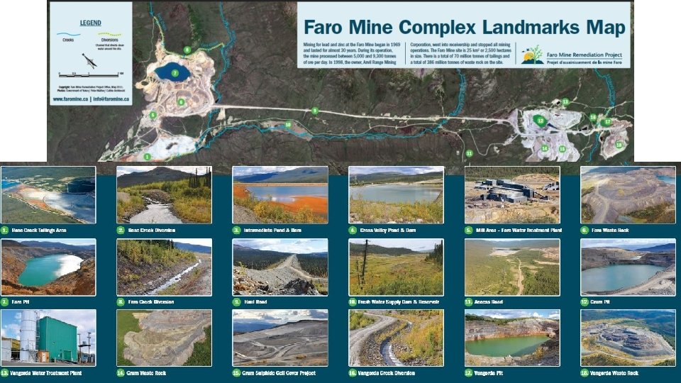
Faro Mine July 24 th 2018 Overflight Aerial Pictures Gerry Whitley/Copyright Yukon Conservation Society Faro Mine Complex Landmarks Map – Faro Mine Remediation Project
Vangorda Pit 1, 150 m long, 350 m wide and 150 m deep
Vangorda Pit and Waste Rock Pile over 16 million tonnes of waste rock
Vangorda Waste Rock and Pit Grum Sulphide Cell and Pit in background - Water Treatment Plant and Pond
Grum Pit pit covers an area of 77 hectares
Grum Sulphide Cell Cover Project 0. 275 square km is covered with a liner and soil to control acid rock drainage
Vangorda Pit with Grum Pit tailings behind 1. 2 km Vangorda Creek Diversion runs between them
Old Breached Fresh Water Supply Dam & Reservoir Between Grum/Vangorda and Faro Pits
Haul Road by Faro Pit (10 km long, connects Grum/Vangorda pits to Faro mill area)
Faro Pit West and North faces
Faro Pit Waste Rock over 260 million tonnes, covers 335 hectares
Faro Mill Area/Water Treatment Plant
Faro Pit with Rose Creek Tailings in Background Pit is 1, 675 m long, 975 m wide and 335 m deep
Faro Pit North Wall and Diversion 3. 35 km Faro Creek Diversion above pit wall
Rose Creek Tailings Area 4 km long, 1 km wide, over 55 million tonnes of tailings
Rose Creek Tailings and Polishing Pond
Rose Creek Tailings Area, Intermediate Pond, and Cross Valley Pond and Dam
Intermediate Pond (r), and Cross Valley Pond (l) and Dam
Thank you for viewing this presentation If you have any questions please contact: Lewis Rifkind, Mining Analyst Yukon Conservation Society Tel: 867 -668 -5678 email: mining@yukonconservation. org www. yukonconservation. org Like What We Do? Become a YCS Member: http: //yukonconservation. org/you-can-help/