Farmland Classification in Montana July 2008 Neal Svendsen


 n The product of K (erodibility by water) x")


 n 11 counties in western Montana have identified farmland of")


 n Specific characteristics of Unique Farmland: n Is used or")


. n")


- Slides: 37
Farmland Classification in Montana July 2008 Neal Svendsen Resource Soil Scientist USDA-Natural Resources Conservation Service Missoula, Montana
Farmland Classification n Identifies the location and extent of the most suitable land for producing food, feed, fiber, forage, and oilseed crops. n Useful in the management of the resource base that supports the productive capacity of American agriculture. (American midwest has the largest area of prime farmland in the world) n National system of land classification, and defined in the Federal Register. n Each soil survey map unit has a farmland designation.
Soil Map Unit Farmland Designations in Western Montana n Prime Farmland, if irrigated n Farmland of Statewide Importance n Farmland of Local Importance n Farmland of Unique Importance
Prime Farmland n Land with the best combination of physical and chemical characteristics for producing crops. n Has the soil quality, growing season, and rainfall needed to economically produce high yields of crops suited to the region. n Current land use is not a criteria – it could be forestland or rangeland. n Very specific soil and climatic criteria (more detailed in handout).
Some of the Prime Farmland Criteria n Soils have a temperature regime warmer than cryic. n n n (Big Hole Valley has cryic temp regime) Have p. H between 4. 5 and 8. 4 in all horizons within 40 inches. Have no water table that limits cultivated crops common to the area. The upper 40 inches has salt content less than 4 mmhos/cm. Not frequently flooded during the growing season. Less than 10% of the surface layer consists of rock fragments larger than 3 inches.
Prime Farmland Criteria (cont. ) n The product of K (erodibility by water) x percent slope is less than 2. 0. n The product of I (erodibility by wind) x C (climatic factor) does not exceed 60. n Precipitation is > 16. 5 inches. n Plant available water holding capacity is > 5 inches in the upper 40 inches of soil; > 4 inches for Prime if irrigated.
Prime Farmland, if irrigated n Same criteria as Prime Farmland, but rainfall is limited. n Needs dependable irrigation supply. n If a field is classified as Prime Farmland, if irrigated but it is not irrigated the classification is Farmland of Statewide Importance.
Farmland of Statewide Importance n Not quite “as good” of soil as prime but still produces high crop yields. n Often a few soil, topographical, or climatic properties outside the prime criteria. n Good example would be slope differences: 317 B Victor loam, 0 to 4 percent slopes is Prime Farmland, if irrigated. n 317 C Victor loam, 4 to 8 percent slopes is Farmland of Statewide Importance. n n Very specific criteria developed by state agriculture agencies and NRCS.
Statewide Importance Criteria n Frost free season > 70 days (not cryic, same as Prime). n Product of K x maximum slope is < 3. 5 (2. 0 for Prime). n Product of I x C is < 80 (<60 for Prime). n Not frequently flooded (same as Prime). n Water table > 24 inches (same as Prime). n Rock fragments greater than 3 inches is < 15%. n Plant available water holding capacity is > 3 inches (5 inches for Prime, 4 inches for Prime, if irrigated). n p. H < 8. 4 in upper 12 inches, and < 9. 0 from 12 to 40 inches (<8. 4 to 40 inches for Prime).
Farmland of Local Importance n Some areas have concern for additional farmlands for the production of food, feed, fiber, and forage. n Not identified as having national or statewide importance, but considered important locally. n Identified by local agencies concerned, typically the local conservation district. n Local agency defines the criteria to be used. (typically based on minimum yield potentials)
Local Importance (cont. ) n 11 counties in western Montana have identified farmland of local importance. n Lake, Mineral, Missoula, Ravalli, Sanders, Beaverhead, Gallatin, Lewis and Clark, Madison, Stillwater, and Sweet Grass n None in eastern Montana. n The main reason NRCS and counties developed farmland of local importance was to make more land eligible for the Farm and Ranch land Protection Program.
Two General Groups of Locally Important Map Units n A soil map unit that is prime or prime, if irrigated on 0 to 4 percent slopes and statewide on 4 to 8 percent slopes would be Locally Important on 8 to 15 percent slopes. (no examples in Missoula County) n A soil map unit that would never be prime or statewide on any slope range. These are usually wet soils or gravelly soils. (72 Moiese gravelly loam, 0 to 2 percent slopes, 110 Turrah silty clay loam, 0 to 2 percent slopes)
Western Montana Local Criteria n Not already designated as Prime, Prime if Irrigated or Statewide, and have one or more of the following: n n Soil map units that have 50% or more named components meeting prime or statewide. Soil map units that have slope < 15%, are not frequently flooded, are poorly drained or better, and where at least 50% of the named components meet at least one of the following minimum yields:
Farm and Ranchland Protection Program n Joins state, tribal, local or non-governmental organizations to acquire conservation easements. n NRCS can provide up to 50% of the fair market easement value. n Part of the eligibility requirement is the land must contain at least 50% prime, unique, statewide, or locally important soils.
Farmland of Unique Importance n Land other than prime farmland that is used for the production of specific high value food and fiber crops. n Has special combination of soil quality, location, growing season, and moisture supply to produce high quality and/or high yields of a specific crop. n Examples are citrus, tree nuts, olives, cranberries, fruits, and vegetables.
Unique Importance (cont. ) n Specific characteristics of Unique Farmland: n Is used or could be used for a specific highvalue food or fiber crop. n Has adequate moisture supply from stored soil moisture, precipitation, or developed irrigation system. n Combines favorable factors of soil quality, growing season, temperature, humidity, air drainage, elevation, aspect, or other conditions, such as nearness to market, that favor the growth of a specific food or fiber crop.
Flathead Lake Unique Farmland n Tempering effect on the regional climate caused by the large water body of Flathead Lake. n This effect results in suitability for cherry orchards and possibly other fruit crops around the lake. n NRCS developed unique farmland criteria for soil map units. Local NRCS employees familiar with cherry production were involved.
Flathead Lake Unique Farmland Criteria n Specific criteria is: n Not already designated as prime, prime if irrigated, statewide, or local. n Within about 1 mile of the lake shore. n Elevation below about 3, 800 feet. n Soils are not sodium affected. n Do not have a seasonal water table within 48 inches. n Slopes are less than 30 percent.
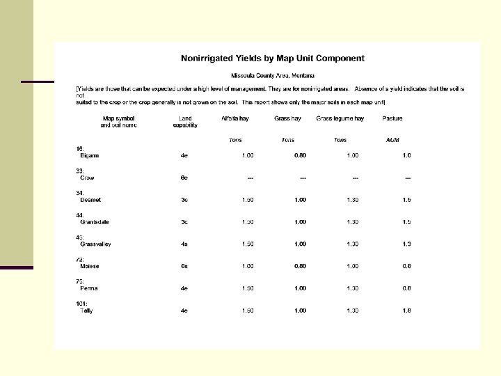
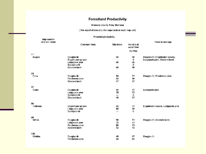
Crop Yields n Soil Surveys include estimates for each soil type (map unit). n Small grains, hay, pasture, forestland tree productivity, cherries, and others. n Yield estimates based on high level of management.
Yield Examples
Missoula County
Missoula County
Missoula County
Missoula County
Missoula County All Farmland Classes
Ravalli County Prime Farmland, if irrigated
Ravalli County Farmland of Statewide Importance
Ravalli County Farmland of Local Importance
Ravalli County All Farmland Classes
Missoula County Important Farmland n All Areas are Prime farmland n n n n 1, 135 ac (0. 07%) Prime Farmland if Irrigated 28, 428 ac (1. 7%) Farmland of Statewide Imp 19, 192 ac (1. 1%) Farmland of Local Importance 81, 528 ac (4. 9%) Total Important Farmlands 130, 283 ac (7. 8%) No Farmland Designation 1, 370, 373 ac Total Acres in Soil Survey Area 1, 500, 631 ac Total County Acres 1, 676, 600 ac
Ravalli County Important Farmland n Prime farmland, if irrigated n n n 20, 000 ac (1. 3%) Farmland of statewide imp 10, 000 ac (0. 7%) Farmland of local Importance 80, 000 ac (5. 2%) Total Important Farmlands 110, 000 ac (7. 2%) No Farmland Designation 272, 000 ac Acres in Soil Survey Area 382, 000 ac Total County Acres 1, 536, 000 ac n Important farmland acres are just an estimate at this time because the update soil survey is not complete.
Farmland Acreages in Montana n Prime Farmland n n n 607, 000 ac (0. 6%) Prime Farmland, if irrigated 6, 055, 000 ac (6. 4%) Farmland of Statewide Imp. 10, 430, 000 ac (11. 1%) Farmland of Local Importance 1, 330, 000 ac (1. 4%) Farmland of Unique Importance 16, 000 ac (0. 02%) (all around Flathead Lake) Total Important Farmland 18, 437, 000 ac (19. 6%) Total land in Montana 94, 050, 000 ac
Important to Know About These Statements n Regardless of the source, these soil maps and associated attribute data are to be used as a primary reference source and are not intended for use in site-specific planning. n This is public information and may be interpreted by organizations, agencies, units of government, or others based on needs; however, you are responsible for the appropriate application. n Federal, state, or local regulatory bodies are not to reassign to the USDA-Natural Resources Conservation Service (NRCS) any authority for the decisions they make. n Further, this statement shall be placed on all documents associated with an analysis or determination completed utilizing NRCS’s soils data or map information.
n Original soil survey maps were compiled on a scale of 1: 24, 000 for most soil survey areas. Portrayal of this information at larger scales (less than 1: 24, 000) may cause the soil map unit boundaries to appear to shift from the original location or appear to shift from an obvious soil boundary. n Also, small areas of contrasting soils that could not be separated at 1: 24, 000 may appear large enough to be mapped separately, depending on type of background map used. n NRCS farmland designations do not apply to lands already converted to non-ag uses (e. g. roads, highways, home sites, subdivisions, urban land. n Open lands that may be idle and not being used for a specific agricultural use still carry the designations.
n For More Information on Soils and Farmland Classification contact: n Neal Svendsen Soil Scientist USDA-NRCS 3550 Mullan Road, Suite 106 Missoula, MT 59808 406 829 -3395, extension 115 neal. svendsen@mt. usda. gov