EXPLAIN 3 Vertical Mixing by Convection Clouds EarthAtmosphere

EXPLAIN 3. Vertical Mixing by Convection & Clouds

Earth-Atmosphere Energy Balance • The air is warmed by the surface • Rising “thermals” of air that were in direct contact with the ground • Condensation of water in clouds
 temperature (K) density (kg m-3) “gas constant” (J")
“Ideal Gas Law” pressure (N m-2) temperature (K) density (kg m-3) “gas constant” (J K-1 kg-1) • Direct relationship between density and pressure • Inverse relationship between density and temperature • Direct relationship between temperature and pressure

What Holds the Air up? What keeps air from always moving downwards due to gravity? A balance between gravity and the pressure gradient force. DP/ Dz = rg rg The “pressure gradient force? ” Pushes from high to low pressure.

Buoyancy An air parcel rises in the atmosphere when its density is less than its surroundings Let renv be the density of the environment. From the Ideal Gas Law renv = P/RTenv Let rparcel be the density of an air parcel. Then rparcel = P/RTparcel Since both the parcel and the environment at the same height are at the same pressure – when Tparcel > Tenv Tparcel < Tenv rparcel < renv (positive buoyancy) rparcel > renv (negative buoyancy)

Stable and Unstable Equilibria Stable Unstable Neutral Conditionally Stable • Stable: when perturbed, system accelerates back toward equilibrium state • Unstable: when perturbed, system accelerates away from equilibrium state

Stability in the atmosphere An Initial Perturbation Stable Unstable Neutral If an air parcel is displaced from its original height it can: Return to its original height - Stable Accelerate upward because it is buoyant - Unstable Stay at the place to which it was displaced - Neutral

Why is stability important? Vertical motions in the atmosphere a critical part of energy transport and strongly influence the hydrologic cycle • Without vertical motion, there would be no precipitation, no mixing of pollutants away from ground level - weather as we know it would simply not exist! • There are two types of vertical motion: – forced motion such as forcing air up over a hill, over colder air, or from horizontal convergence – buoyant motion in which the air rises because it is less dense than its surroundings

Trading Height for Heat Suppose a parcel exchanges no energy with its surroundings … we call this state adiabatic, meaning, “not gaining or losing energy” “Dry lapse rate”

Dry Lapse Rate 10 degrees C per kilometer Warming and Cooling due to changing pressure

Stability and the Dry Lapse Rate • A rising air parcel cools according to the dry lapse rate (10 o C per km) • If rising, cooling air is: – warmer than surrounding air it is less dense and buoyancy accelerates the parcel upward … UNSTABLE! – colder than surrounding air it is more dense and buoyancy opposes (slows) the rising motion … STABLE!

Unstable Atmosphere • The atmosphere is unstable if the air cools more than 10 o C/km • This situation is rare in nature (not long-lived) – Usually results from surface heating and is confined to a shallow layer near the surface – Vertical mixing wipes it out! • Mixing results in a dry lapse rate in the mixed layer, unless clouds form

• The atmosphere is stable if the air cools less than 10 o. C / km • This situation is common in nature (happens most calm nights, esp in winter) – Usually results from surface cooling and is confined to a shallow layer near the surface – Vertical mixing or surface heating wipes it out Stable Atmosphere

Water Vapor, Liquid Water, & Air • Water molecules jump back & forth from liquid to gas • When vapor & liquid are in equilibrium, the air is “saturated” • Saturation vapor pressure increases dramatically with T • “Warm air can hold more water vapor than cold air”

Moist Adiabatic Lapse Rate Warming and cooling due to both changes in pressure and latent heat release Rising air with condensing water cools much more slowly with height than dry air

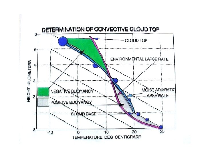
• If the environmental lapse rate falls between the moist and dry lapse rates: – The atmosphere is unstable for saturated air parcels but stable for dry air parcels – This situation is termed conditionally unstable • This is the most typical situation in the lower atmosphere Conditionally unstable air

Cloud and fog drop formation • If the air temperature cools below the dew point (RH > 100%), water vapor will condense to form cloud / fog droplets • Drop formation occurs on particles known as cloud condensation nuclei (CCN) • The most effective CCN are water soluble • Without particles clouds would not form in the atmosphere!

Cloud Droplets are Tiny!

Steps in Cloud/Fog Formation • Air parcel cools causing RH to increase – Radiative cooling at surface (fog) – Expansion in rising parcel (cloud) • CCN (tenths of a micron!) take up water vapor as RH increases • If RH is high enough, droplets are activated and grow readily into cloud drops (10’s of microns)

“Popcorn Clouds” • “Fair weather cumulus” • Very common in late morning • Buoyant thermals due to surface heating • They rise and cool at dry lapse rate (10 C / km) • Clouds form at height where RH = 100% Fair-weather Clouds Rising warm air Hot sfc

Precipitation Formation How can precipitation form from tiny cloud drops? 1. “Warm rain” process can produce drizzle 2. “Ice multiplication” forms fat raindrops How many 20 µm cloud drops does it take to make a 2000 µm rain drop? V = 4/3 pr 3 = pd 3/6 (2000/20) 3 = 1, 000

• When RH > 100%, activated cloud drops grow by water vapor condensation – It takes many hours for the cloud drop to approach rain drop size • Collisions between cloud drops can produce large rain drops much faster through coalescence • Rain formation is fastest when there is a – Wide range of drop sizes – Thick cloud – Fast updrafts Rain formation in warm clouds (no ice)

Rain formation in warm clouds • Capture of a cloud/rain drop in a cloud updraft can give it more time to grow • The drop falls at a fixed speed relative to the air, not the ground • Large drops fall faster

Ice crystal growth by accretion • Ice crystals fall faster than cloud drops • Crystal/drop collisions allow ice crystals to capture cloud drops – The supercooled drops freeze upon contact with the ice crystal – This process is known as accretion or riming • Crystals melt as they fall to form big raindrops that go “splat!”

Ice Crystal Processes in Cold Clouds • Outside deepest tropics most precipitation is formed via ice crystal growth • Supercooled cloud drops and ice crystals coexist for – 40º < T < 0º C • Ice crystals grow by – Water vapor deposition – Capture of cloud drops (accretion/riming) – Aggregation

Precipitation in cold clouds • Low liquid water content promotes diffusion/deposition growth of large crystals • High liquid water content promotes riming and formation of graupel/hail • If the sub-cloud layer is warm, snow or graupel may melt into raindrops before reaching the surface (typical process for summer rain in Colorado)

Hail • Hail can form in clouds with – High supercooled liquid water content – Very strong updrafts decoupled from downdrafts • Hailstones typically make 2 -3 trips up through cloud • Opaque & clear ice layers – Opaque is from rapid freezing high up – Clear represents slower freezing with lots of liquid – Layering tells about hailstone history The largest hailstone ever recovered in the United States, a seven -inch (17. 8 centimeter) wide chunk of ice almost as large as a soccer ball. It was found in Aurora, Nebraska on June 22, 2003. The hailstone lost nearly half of its mass upon landing on the rain gutter of a house

Lifecycle of a Simple Thunderstorm • Updraft • Glaciation • Rain shaft • Anvil • Collapse • Cirrus “debris”

stratosphere very dry overshooting top vapor + ice liquid + vapor + ice free troposphere anvil dry air entrainment moist updrafts liquid + vapor boundary layer water vapor

Remember • Earth gets all of its heat from solar radiation • Earth has to give back all of its heat through thermal radiation • Air is almost opaque to thermal radiation • Heat has to get to upper air by vertical mixing (convection) • Rising thermals and condensation of clouds provide the lift!
- Slides: 31