Experiences with 0 36 h Explicit Convective Forecasting


.")


 • Stratiform regions appear too small")


 4 km 10 km")

 CAT 2: some organization")
- Slides: 32
Experiences with 0 -36 h Explicit Convective Forecasting with the WRF-ARW Model Morris Weisman (Wei Wang, Chris Davis) NCAR/MMM WSN 05 September 8, 2005
Composite NEXRAD Radar 00 UTC 6/10/03 - 12 UTC 6/11/03
WRF Realtime Convective Forecasting May 1 – July 31 4 km 00 UTC -- 36 h 2003, 2004, 2005
WRF Real-time Forecasts: 2004, 2005 § 4 -km from 0000 UTC - 36 h §Version 1. 3 (2. 0. 3. 1) §Eta initial and boundary conditions (40 km) §Physics: Lin et al. (5 cat. ) microphysics (WSM 6) YSU PBL (first-order closure) Noah LSM (HRLDAS) § 2000 km X 2000 km domain / 2800 km X 2600 km domain § 5. 0 h (6. 5 h) on 128 (192) IBM Power-4 processors
Real-time WRF 4 km Forecast Initialized 00 UTC 9 June 03 Reflectivity forecast Composite NEXRAD Radar
Real-time WRF 4 km Forecast Initialized 00 UTC 10 June 03 Reflectivity forecast Composite NEXRAD Radar
Consider the 24 -30 h forecast challenge (i. e. , the next diurnal cycle). How does the 4 km WRF-ARW ‘’guidance’’ compare to the 12 km operational ETA?
May 30, 2004 Radar 03 GMT 4 km WRFARW 03 GMT 27 hr 06 GMT prec. 12 km ETA 30 hr
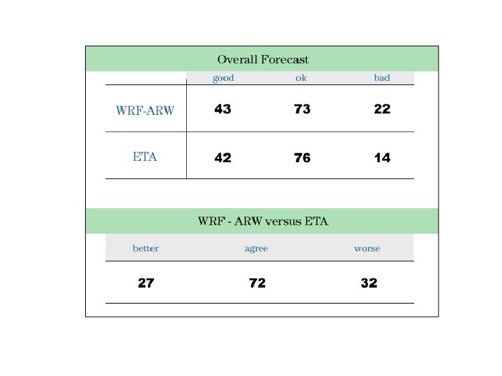
Overall Forecast Good: OK: Bad: WRF RADAR
How well does 4 -km WRF represent the climatological behavior of convection? (e. g. , diurnal cycle, episodes)
Longitudinal 1 hr Precip. May 10 -31, 2004 Stage IV WRF
Diurnal Average Frequency: May 10 -July 31 2004 Stage IV 4 km WRF
Diurnal Average 3 hr Precip. Stage IV 4 km WRF 12 km ETA
Initialized 04 June 2005 00 UTC Reflectivity forecast Composite NEXRAD Radar
24 h forecast Valid 00 UTC 06/05/05 4 -km ARW 4 -km NMM 2 -km ARW Nexrad
0500 UTC 29 April 2005: 1 km model reflectivity, NEXRAD BREF ARW 4 NMM 4 ARW 2 BREF
Progress 4 km WRF-ARW simulations exhibit: § A surprising ability to forecast mesoscale convective systems (MCS) out to 36 h ( strongly controlled by 12 -km ETA forcing) §A demonstrated skill at depicting MCS mode (bow echoes, mesoscale convective vortices, supercell lines) §A more accurate depiction of diurnal cycle and precipitation episodes §An ability to spin-up convective systems within 3 -4 h from a cold start.
Challenge: • QPF problematic (too much convective precip) • Stratiform regions appear too small (microphysics? ) • Convective systems often fail to decay (BL evolution? ) • Initialization (data assimilation) • Verification methods
WRF-ARW 2005 real-time forecasts can be found at: http: //box. mmm. ucar. edu/projects/wrf_spring/ http: //rain. mmm. ucar. edu/mm 5/ Also archived at: http: //www. joss. ucar. edu/wrf-2004/catalog/ http: //www. joss. ucar. edu/wrf-2005/catalog/
OBS 24 hr precipitation verification 4 km WRF Valid 6/10/03 12 UTC 10 km WRF 12 km ETA
4 km WRF 12 h Precipitation Forecast Valid 10 June 2003 12 Z Lin, et al. Scheme WSM-6 Scheme Reisner Scheme SB 2004 Scheme NCEP Stage 4 Data Total Precipitation (mm) (Axel Seifert, 2004)
4 km WRF 12 h Reflectivity Forecast Valid 10 June 2003 12 Z Lin, et al. Scheme WSM-6 Scheme Reisner Scheme SB 2004 Scheme NEXRAD Composite Column Max Reflectivity (d. BZ) (Axel Seifert, 2004)
Lin WSM-6 12 h Surface Theta Reisner SB 2004
Sounding comparison: 24 h forecast valid 00 Z 24 May at DDC ARW 4 Good forecast… Model Raob NMM 4 Model Raob PBL too shallow, cold, & moist… clouds just broke up!
Sounding comparison: 24 h forecast valid 00 Z 18 May at DDC ARW 4 Model Raob NMM 4 Too dry in PBL, too moist above; Where is the PBL top? Good forecast… Raob Model
Sounding comparison: 24 h forecast valid 00 Z 28 April at OUN ARW 4 Raob Good in PBL, but CIN layer is washed out Model NMM 4 Raob Model PBL too shallow and moist, but CIN layer looks good
24 h Reflectivity Forecast valid 4 -30 -05 00 Z 4 km WRF-ARW 4 km WRF-NMM 2 km WRF-ARW Radar
Diurnal Average (2003) 4 km 10 km
Model Physics in High Resolution NWP Physics “No Man’s Land” 1 Resolved Convection 3 -D Radiation LES 10 100 km Cumulus Parameterization Two Stream Radiation PBL Parameterization
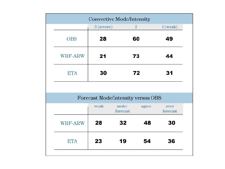
Convective Mode/Intensity CAT 3: severe, well organized (> 1 in) CAT 2: some organization (. 251. 0 in) CAT 1: weak, disorganized (<. 25 in) WRF ETA