Example Spatial distribution What processes create and sustain

Example: Spatial distribution What processes create and sustain the pattern of a distribution? Map of Cholera Victims in London’s Soho District in 1854. The patterns of victim’s homes and water pump locations helped uncover the source of the disease.

Spatial Distribution • The arrangement of items on the earth’s surface • Analyzed by the elements common to all spatial distributions • Density, Dispersion, and Pattern

Density • The measure of the number or quantity of anything within a defined unit of area • Always number in relation to area • Normally used comparatively

Density • GA pop. Density = 141 per/sq mi • Is that a high density? • Who knows… we must look comparatively – Ohio = 277, Michigan = 175, – New Jersey = 1134 • Therefore GA has a low Density • Wyoming = 6 • Gwinnett? 1360

Dispersion • Spread of a phenomenon over an area • Not how many or how much but how far things are spread out 1. Clustered/Agglomerated = spatially close together 2. Dispersed/Scattered = spread out – - Dispersion can change depending on scale

Pattern • The geometric arrangement of objects in space • Pattern refers to distribution, but the reference emphasizes design rather than spacing • Types of Patterns: Linear, Centralized, and Random

Linear Pattern • Linear Patterns typically depict houses along a street or towns along a railroad

Centralized Pattern • Centralized Patterns typically involve items concentrated around a single node • Ex: Center City with surrounding suburbs

Random Pattern • An unstructured irregular distribution

Regions 1. Formal/Uniform region: defined by a commonality, typically a cultural linkage or a physical characteristic. e. g. German speaking region of Europe

Regions 2. Functional/Nodal region: defined by a set of social, political, or economic activities or the interactions that occur within it. e. g. an urban area, magazine circulation, radio station

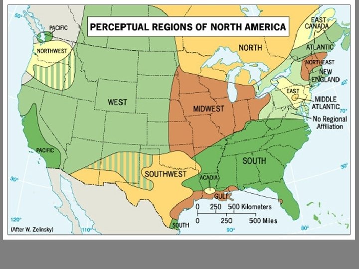
Regions 3. Perceptual Region/Vernacular: ideas in our minds, based on accumulated knowledge of places and regions, that define an area of “sameness” or “connectedness. ” – e. g. the South the Mid-Atlantic the Middle East

The meanings of regions are often contested. In Montgomery, Alabama, streets named after Confederate President Jefferson Davis and Civil Rights leader Rosa Parks intersect. Photo credit: Jonathan Leib

Region v. Realm • Realms are larger, and several regions – e. g. often encompass

“core-domain sphere” model – Created by Donald Meinig • - Core Region: distinctive attributes • - Domain: dominant but not exclusive • - Sphere: present but not dominant

Key Question: What are Geographic Questions?

Key Question: Why do Geographers use Maps, and What do Maps Tell Us?

Two Types of Maps: Reference Maps Thematic Maps - Show locations of places - Tell a story about the and geographic features degree of an attribute, the pattern of its - Absolute locations distribution, or its movement. - Relative locations What are reference maps What are thematic maps used for?

Reference Map

Thematic Maps • Thematic Maps: a map depicting a specific spatial distribution or statistical variation of abstract objects (e. g. unemployment) in space • TYPES: Graduated Circle, Dot-Distribution, Isopleth, and Choropleth

Thematic Map What story about median income in the Washington, DC area is this map telling?

• Graduate Circle Map • Uses circles of different sizes to show the frequency of occurrence of a certain topic

• Dot-distribution Map • A single of specified number of occurrences are recorded by a single dot

• Isopleth Map • Calculation refers not to a point but to an areal statistic • The isoline connects average values per unit

• Choropleth Map • Present average value of the data studied per preexisting areal unit

Mental Maps: • maps we carry in our minds of places we have been and places we have heard of. – can see: terra incognita, landmarks, paths, and accessibility Activity Spaces: • the places we travel to routinely in our rounds of daily activity. – How are activity spaces and mental maps related?

Geographic Information System: a collection of computer hardware and software that permits storage and analysis of layers of spatial data.

Remote Sensing: a method of collecting data by instruments that are physically distant from the area of study.

Key Question: Why are Geographers Concerned with Scale and Connectedness?

Scale is the territorial extent of something. The observations we make and the context we see vary across scales, such as: - local - regional - national - global

Scale

Scale is a powerful concept because: • Processes operating at different scales influence one another. • What is occurring across scales provides context for us understand a phenomenon. • People can use scale politically to change who is involved or how an issue is perceived. – e. g. Zapatistas rescale their movement – e. g. laws jump scales, ignoring cultural differences to

Old Approaches to • Human-Environment Questions: – Environmental Determinism (has been rejected by almost all geographers) – Possibilism (less accepted today) New Approaches to • Human-Environment Questions: – Cultural ecology – Political ecology
- Slides: 35