Evolution of an Alpine Lee Cyclone An attribution
Evolution of an Alpine Lee Cyclone An attribution study examining the effects of surrounding orography on the development and morphology of a subsynoptic cyclone in the Gulf of Genoa (15 -16 November 2007) Ron Mc. Taggart-Cowan 1 and Tom Galarneau Jr. 2 1 Environment Canada 2 University at Albany
Outline Review of subsynoptic cyclogenesis mechanisms: Alpine lee cyclones Polar lows Mediterranean “hurricanes” Analysis of 15 November 2007 lee cyclone Forecast model (CMCGEML/CMCGEMH) development of lee cyclone Attribution integrations with modified orography Discussion
Alpine Lee Cyclones Review of Mesoscale Cyclogenesis Form during periods of strong cross-barrier flow combined with orographic cold frontal blocking and splitting of the airstream around the obstacle Warm air left in the lee acts as a boundary PV anomaly: cyclonic flow and pressure perturbation Mesoscale mechanisms concentrate PV: GW or friction-induced PV banners Diabatic vertical redistribution of PV by convection Convective coupling may enhance interaction with upper trough during baroclinic development
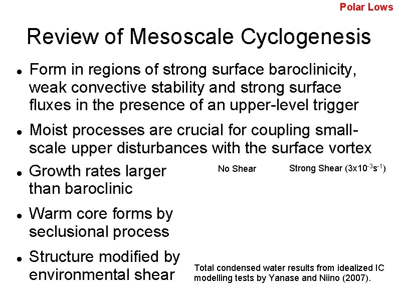
Polar Lows Review of Mesoscale Cyclogenesis Form in regions of strong surface baroclinicity, weak convective stability and strong surface fluxes in the presence of an upper-level trigger Moist processes are crucial for coupling smallscale upper disturbances with the surface vortex Strong Shear (3 x 10 s No Shear Growth rates larger than baroclinic -3 -1) Warm core forms by seclusional process Structure modified by environmental shear Total condensed water results from idealized IC modelling tests by Yanase and Niino (2007).
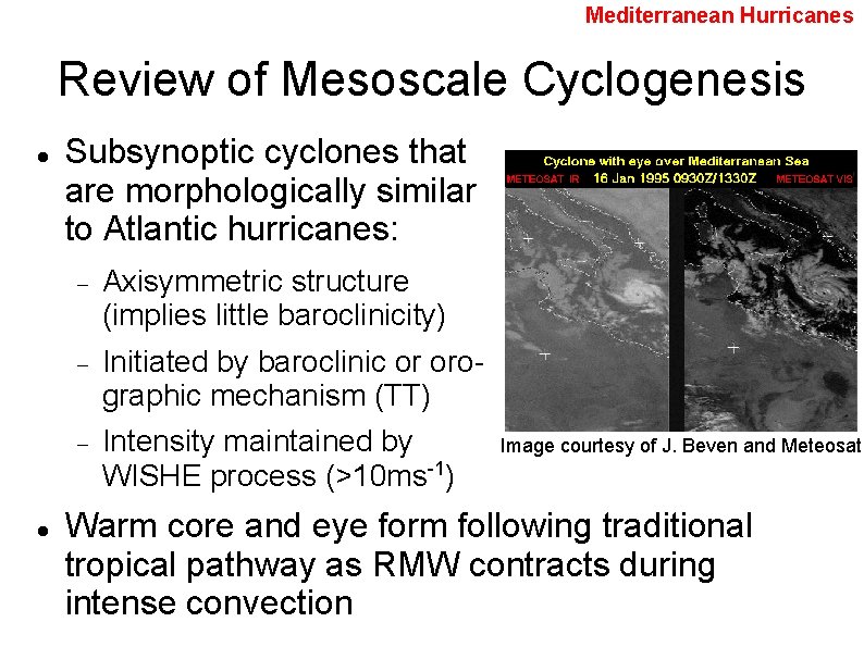
Mediterranean Hurricanes Review of Mesoscale Cyclogenesis Subsynoptic cyclones that are morphologically similar to Atlantic hurricanes: Axisymmetric structure (implies little baroclinicity) Initiated by baroclinic or orographic mechanism (TT) Intensity maintained by WISHE process (>10 ms-1) Image courtesy of J. Beven and Meteosat Warm core and eye form following traditional tropical pathway as RMW contracts during intense convection
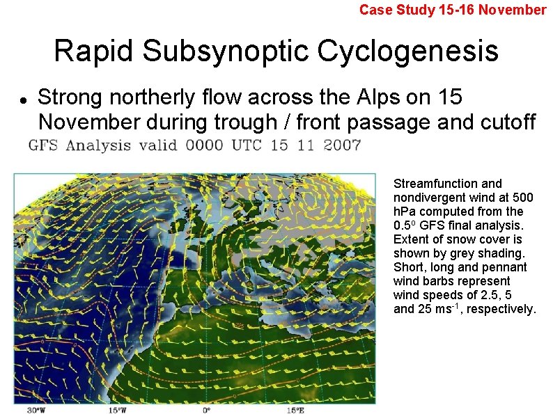
Case Study 15 -16 November Rapid Subsynoptic Cyclogenesis Strong northerly flow across the Alps on 15 November during trough / front passage and cutoff Streamfunction and nondivergent wind at 500 h. Pa computed from the 0. 5 o GFS final analysis. Extent of snow cover is shown by grey shading. Short, long and pennant wind barbs represent wind speeds of 2. 5, 5 and 25 ms-1, respectively.
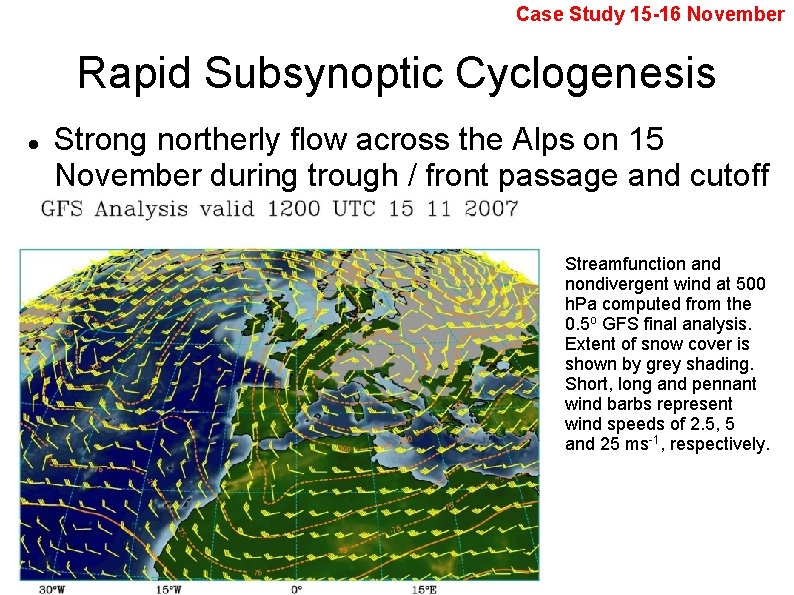
Case Study 15 -16 November Rapid Subsynoptic Cyclogenesis Strong northerly flow across the Alps on 15 November during trough / front passage and cutoff Streamfunction and nondivergent wind at 500 h. Pa computed from the 0. 5 o GFS final analysis. Extent of snow cover is shown by grey shading. Short, long and pennant wind barbs represent wind speeds of 2. 5, 5 and 25 ms-1, respectively.

Case Study 15 -16 November Rapid Subsynoptic Cyclogenesis Strong northerly flow across the Alps on 15 November during trough / front passage and cutoff Streamfunction and nondivergent wind at 500 h. Pa computed from the 0. 5 o GFS final analysis. Extent of snow cover is shown by grey shading. Short, long and pennant wind barbs represent wind speeds of 2. 5, 5 and 25 ms-1, respectively.
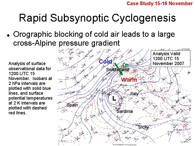
Case Study 15 -16 November Rapid Subsynoptic Cyclogenesis Orographic blocking of cold air leads to a large cross-Alpine pressure gradient Analysis of surface observational data for 1200 UTC 15 November. Isobars at 2 h. Pa intervals are plotted with solid blue lines, and surface potential temperatures at 2 K intervals are plotted with dashed red lines. Cold Analysis Valid 1200 UTC 15 November 2007 ∆P Switzerland Warm L Italy Spain Sardinia Sicily
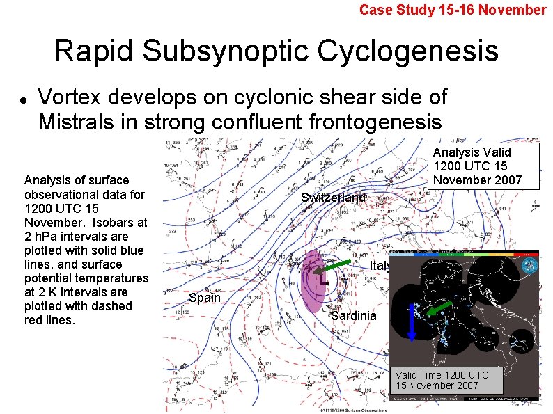
Case Study 15 -16 November Rapid Subsynoptic Cyclogenesis Vortex develops on cyclonic shear side of Mistrals in strong confluent frontogenesis Analysis of surface observational data for 1200 UTC 15 November. Isobars at 2 h. Pa intervals are plotted with solid blue lines, and surface potential temperatures at 2 K intervals are plotted with dashed red lines. Analysis Valid 1200 UTC 15 November 2007 Switzerland L Italy Spain Sardinia Sicily Valid Time 1200 UTC 15 November 2007
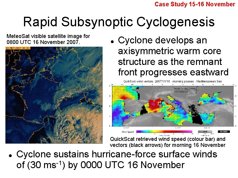
Case Study 15 -16 November Rapid Subsynoptic Cyclogenesis Meteo. Sat visible satellite image for 0800 UTC 16 November 2007. Cyclone develops an axisymmetric warm core structure as the remnant front progresses eastward Quick. Scat retrieved wind speed (colour bar) and vectors (black arrows) for morning 16 November Cyclone sustains hurricane-force surface winds of (30 ms-1) by 0000 UTC 16 November
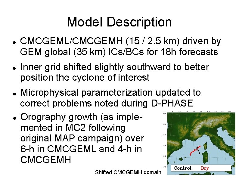
Model Description CMCGEML/CMCGEMH (15 / 2. 5 km) driven by GEM global (35 km) ICs/BCs for 18 h forecasts Inner grid shifted slightly southward to better position the cyclone of interest Microphysical parameterization updated to correct problems noted during D-PHASE Orography growth (as implemented in MC 2 following original MAP campaign) over 6 -h in CMCGEML and 4 -h in CMCGEMH Shifted CMCGEMH domain
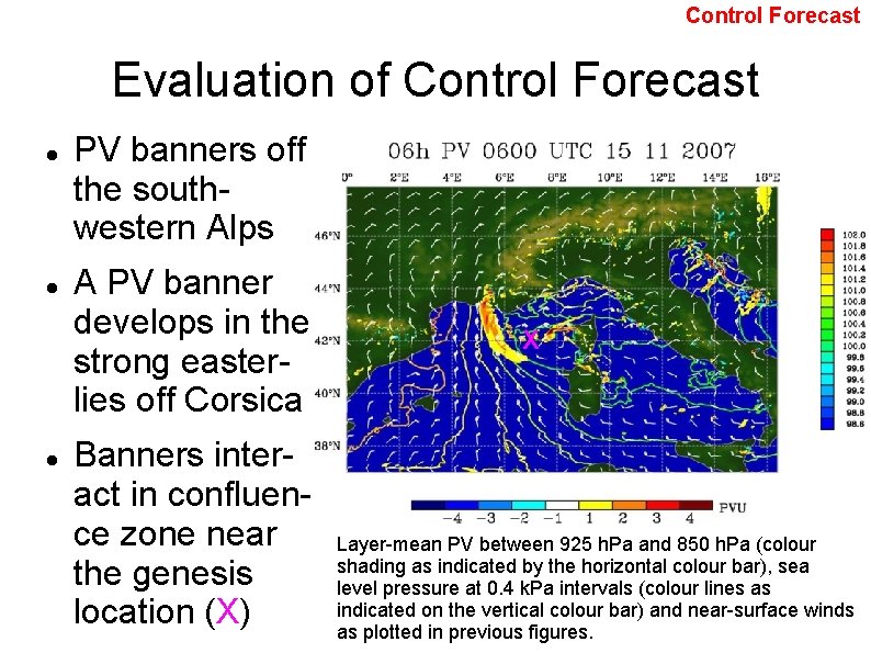
Control Forecast Evaluation of Control Forecast PV banners off the southwestern Alps A PV banner develops in the strong easterlies off Corsica Banners interact in confluence zone near the genesis location (X) X Layer-mean PV between 925 h. Pa and 850 h. Pa (colour shading as indicated by the horizontal colour bar), sea level pressure at 0. 4 k. Pa intervals (colour lines as indicated on the vertical colour bar) and near-surface winds as plotted in previous figures.
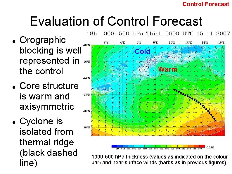
Control Forecast Evaluation of Control Forecast Orographic blocking is well represented in the control Cold Warm Core structure is warm and axisymmetric Cyclone is isolated from thermal ridge (black dashed line) 1000 -500 h. Pa thickness (values as indicated on the colour bar) and near-surface winds (barbs as in previous figures)
Attribution Testing Strategy Orographic features are eliminated sequentially in order to assess their impacts on storm evolution Features are replaced with orography statistically similar to surrounding non-mountainous regions Full reforecast cycles are run (global, CMCGEML, CMCGEMH) for each orography change Orographic growth eliminates shock generation usually associated with orographic modification
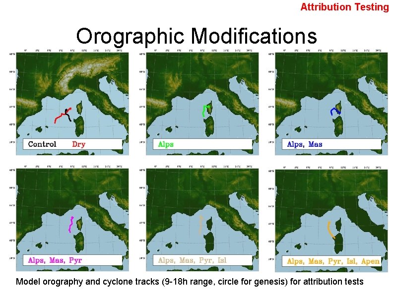
Attribution Testing Orographic Modifications Model orography and cyclone tracks (9 -18 h range, circle for genesis) for attribution tests
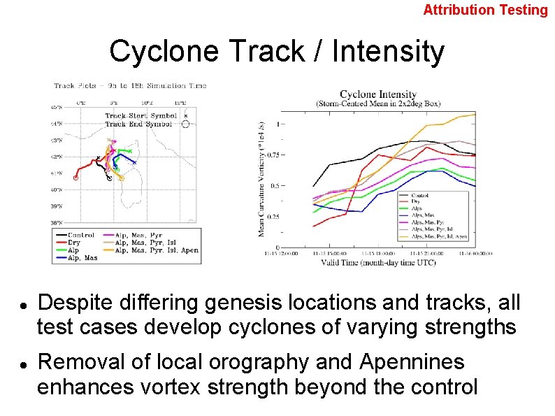
Attribution Testing Cyclone Track / Intensity Despite differing genesis locations and tracks, all test cases develop cyclones of varying strengths Removal of local orography and Apennines enhances vortex strength beyond the control
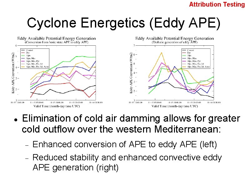
Attribution Testing Cyclone Energetics (Eddy APE) Elimination of cold air damming allows for greater cold outflow over the western Mediterranean: Enhanced conversion of APE to eddy APE (left) Reduced stability and enhanced convective eddy APE generation (right)
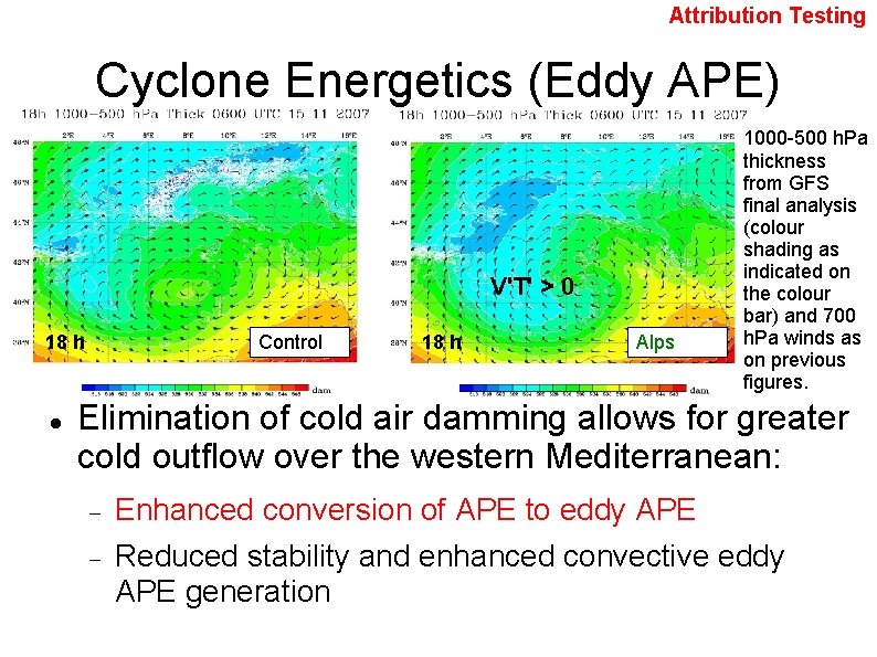
Attribution Testing Cyclone Energetics (Eddy APE) V'T' > 0 18 h Control 18 h Alps 1000 -500 h. Pa thickness from GFS final analysis (colour shading as indicated on the colour bar) and 700 h. Pa winds as on previous figures. Elimination of cold air damming allows for greater cold outflow over the western Mediterranean: Enhanced conversion of APE to eddy APE Reduced stability and enhanced convective eddy APE generation
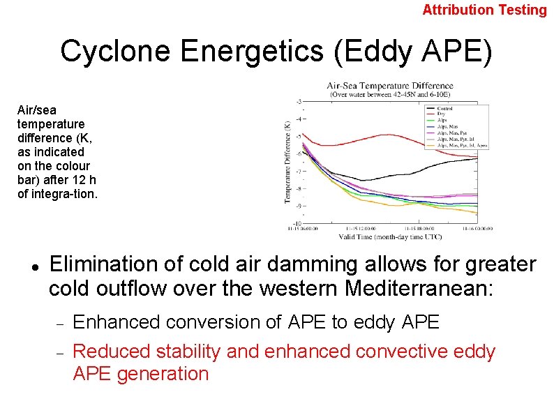
Attribution Testing Cyclone Energetics (Eddy APE) Air/sea temperature difference (K, as indicated on the colour bar) after 12 h of integra-tion. Elimination of cold air damming allows for greater cold outflow over the western Mediterranean: Enhanced conversion of APE to eddy APE Reduced stability and enhanced convective eddy APE generation
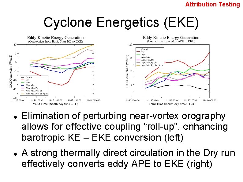
Attribution Testing Cyclone Energetics (EKE) Elimination of perturbing near-vortex orography allows for effective coupling “roll-up”, enhancing barotropic KE – EKE conversion (left) A strong thermally direct circulation in the Dry run effectively converts eddy APE to EKE (right)
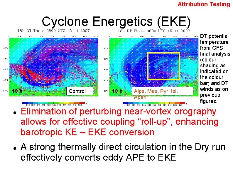
Attribution Testing Cyclone Energetics (EKE) 18 h Control 18 h Alps, Mas, Pyr, Isl, Apen DT potential temperature from GFS final analysis (colour shading as indicated on the colour bar) and DT winds as on previous figures. Elimination of perturbing near-vortex orography allows for effective coupling “roll-up”, enhancing barotropic KE – EKE conversion A strong thermally direct circulation in the Dry run effectively converts eddy APE to EKE
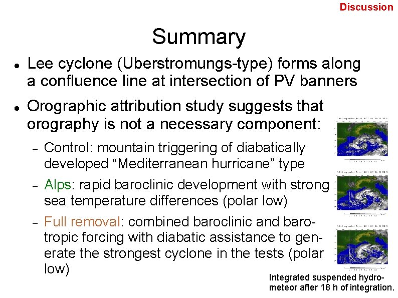
Discussion Summary Lee cyclone (Uberstromungs-type) forms along a confluence line at intersection of PV banners Orographic attribution study suggests that orography is not a necessary component: Control: mountain triggering of diabatically developed “Mediterranean hurricane” type Alps: rapid baroclinic development with strong sea temperature differences (polar low) Full removal: combined baroclinic and barotropic forcing with diabatic assistance to generate the strongest cyclone in the tests (polar low) Integrated suspended hydro- air- meteor after 18 h of integration.
Discussion Conclusion The mountains are not a necessary condition. . . Alpine (and surrounding) orography modifies the morphology of the “lee cyclone” in this case by modifying the regional flow, but does so in the context of an atmosphere already pre-disposed to rapid sub-synoptic cyclogenesis.
- Slides: 24