Evaluating parameterized variables in the Community Atmospheric Model

Evaluating parameterized variables in the Community Atmospheric Model along the GCSS Pacific cross-section during YOTC Cécile Hannay, Dave Williamson, Rich Neale, Jerry Olson, Dennis Shea National Center for Atmospheric Research, Boulder AGU Meeting, San Francisco, December 14 -18, 2009
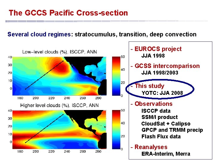
The GCCS Pacific Cross-section Several cloud regimes: stratocumulus, transition, deep convection - EUROCS project JJA 1998 - GCSS intercomparison JJA 1998/2003 - This study YOTC: JJA 2008 - Observations ISCCP data SSM/I product Cloud. Sat + Calipso GPCP and TRMM precip Flash Flux data - Reanalyses ERA-Interim, Merra
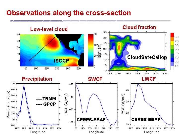
Observations along the cross-section Cloud fraction Low-level cloud Cloud. Sat+Caliop ISCCP Precipitation SWCF LWCF __ TRMM ---- GPCP CERES-EBAF
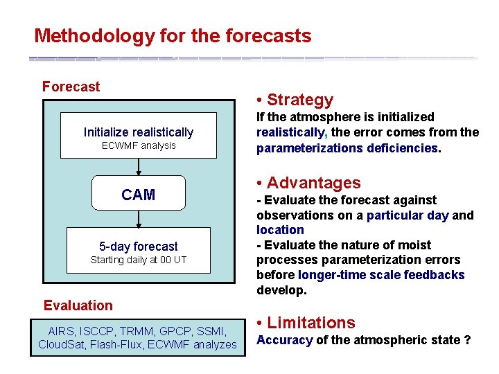
Methodology for the forecasts Forecast • Strategy Initialize realistically ECWMF analysis CAM 5 -day forecast Starting daily at 00 UT Evaluation AIRS, ISCCP, TRMM, GPCP, SSMI, Cloud. Sat, Flash-Flux, ECWMF analyzes If the atmosphere is initialized realistically, the error comes from the parameterizations deficiencies. • Advantages - Evaluate the forecast against observations on a particular day and location - Evaluate the nature of moist processes parameterization errors before longer-time scale feedbacks develop. • Limitations Accuracy of the atmospheric state ?
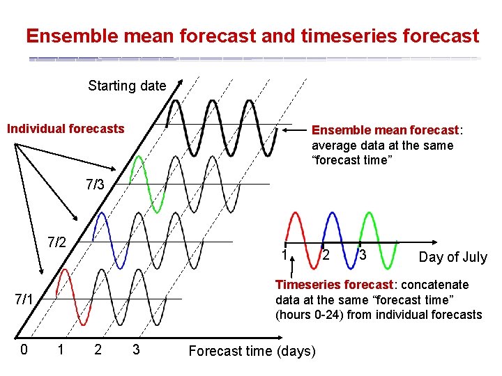
Ensemble mean forecast and timeseries forecast Starting date Individual forecasts Ensemble mean forecast: average data at the same “forecast time” 7/3 7/2 1 3 Day of July Timeseries forecast: concatenate data at the same “forecast time” (hours 0 -24) from individual forecasts 7/1 0 2 1 2 3 Forecast time (days)
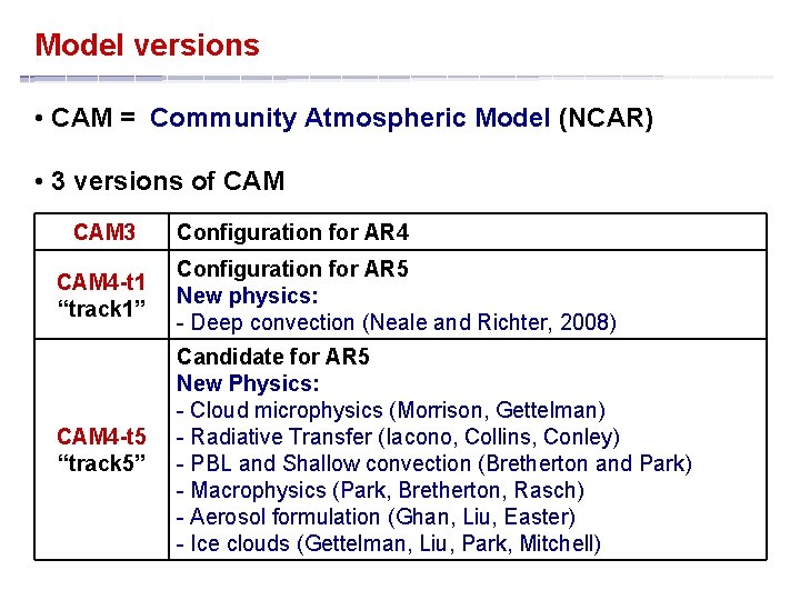
Model versions • CAM = Community Atmospheric Model (NCAR) • 3 versions of CAM 3 Configuration for AR 4 CAM 4 -t 1 “track 1” Configuration for AR 5 New physics: - Deep convection (Neale and Richter, 2008) CAM 4 -t 5 “track 5” Candidate for AR 5 New Physics: - Cloud microphysics (Morrison, Gettelman) - Radiative Transfer (Iacono, Collins, Conley) - PBL and Shallow convection (Bretherton and Park) - Macrophysics (Park, Bretherton, Rasch) - Aerosol formulation (Ghan, Liu, Easter) - Ice clouds (Gettelman, Liu, Park, Mitchell)
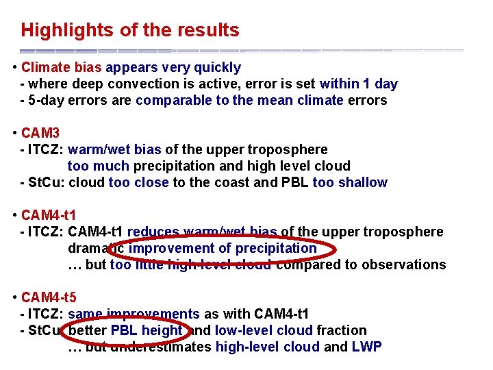
Highlights of the results • Climate bias appears very quickly in CAM - where deep convection is active, error is set within 1 day - 5 -day errors are comparable to the mean climate errors • CAM 3 - ITCZ: warm/wet bias of the upper troposphere too much precipitation and high level cloud - St. Cu: cloud too close to the coast and PBL too shallow • CAM 4 -t 1 - ITCZ: CAM 4 -t 1 reduces warm/wet bias of the upper troposphere dramatic improvement of precipitation … but too little high-level cloud compared to observations • CAM 4 -t 5 - ITCZ: same improvements as with CAM 4 -t 1 - St. Cu: better PBL height and low-level cloud fraction … but underestimates high-level cloud and LWP
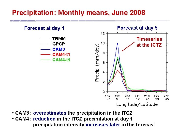
Precipitation: Monthly means, June 2008 Forecast at day 1 ____ ____ TRMM GPCP CAM 3 CAM 4 -t 1 CAM 4 -t 5 Forecast at day 5 Timeseries at the ICTZ • CAM 3: overestimates the precipitation in the ITCZ • CAM 4: reduction in the ITCZ precipitation at day 1 precipitation intensity increases later in the forecast
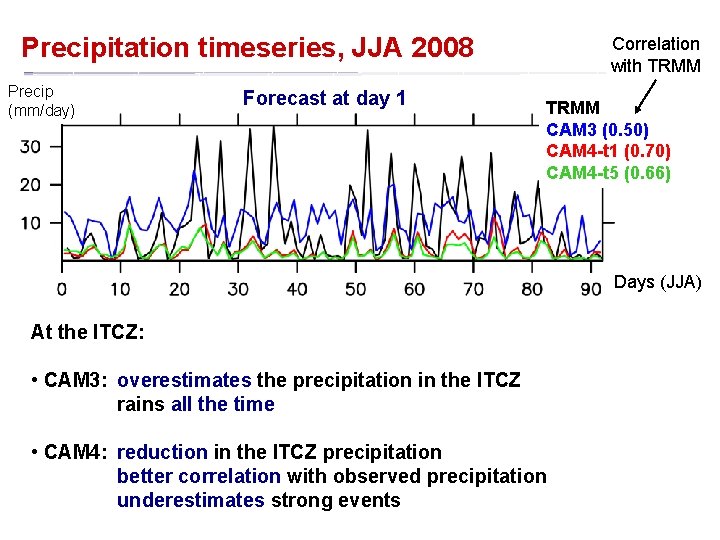
Precipitation timeseries, JJA 2008 Precip (mm/day) Forecast at day 1 Correlation with TRMM CAM 3 (0. 50) CAM 4 -t 1 (0. 70) CAM 4 -t 5 (0. 66) Days (JJA) At the ITCZ: • CAM 3: overestimates the precipitation in the ITCZ rains all the time • CAM 4: reduction in the ITCZ precipitation better correlation with observed precipitation underestimates strong events
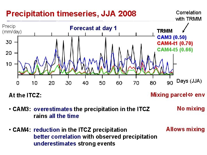
Precipitation timeseries, JJA 2008 Precip (mm/day) Forecast at day 1 Correlation with TRMM CAM 3 (0. 50) CAM 4 -t 1 (0. 70) CAM 4 -t 5 (0. 66) Days (JJA) At the ITCZ: Mixing parcel env • CAM 3: overestimates the precipitation in the ITCZ rains all the time • CAM 4: reduction in the ITCZ precipitation better correlation with observed precipitation underestimates strong events No mixing Allows mixing
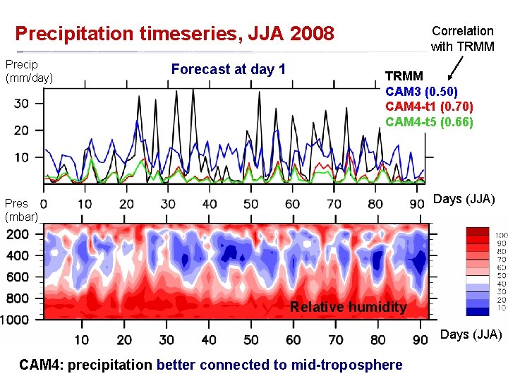
Precipitation timeseries, JJA 2008 Precip (mm/day) Forecast at day 1 Correlation with TRMM CAM 3 (0. 50) CAM 4 -t 1 (0. 70) CAM 4 -t 5 (0. 66) Days (JJA) Pres (mbar) Relative humidity Days (JJA) CAM 4: precipitation better connected to mid-troposphere
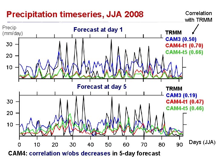
Precipitation timeseries, JJA 2008 Precip (mm/day) Forecast at day 1 Forecast at day 5 Correlation with TRMM CAM 3 (0. 50) CAM 4 -t 1 (0. 70) CAM 4 -t 5 (0. 66) TRMM CAM 3 (0. 19) CAM 4 -t 1 (0. 47) CAM 4 -t 5 (0. 46) Days (JJA) CAM 4: correlation w/obs decreases in 5 -day forecast
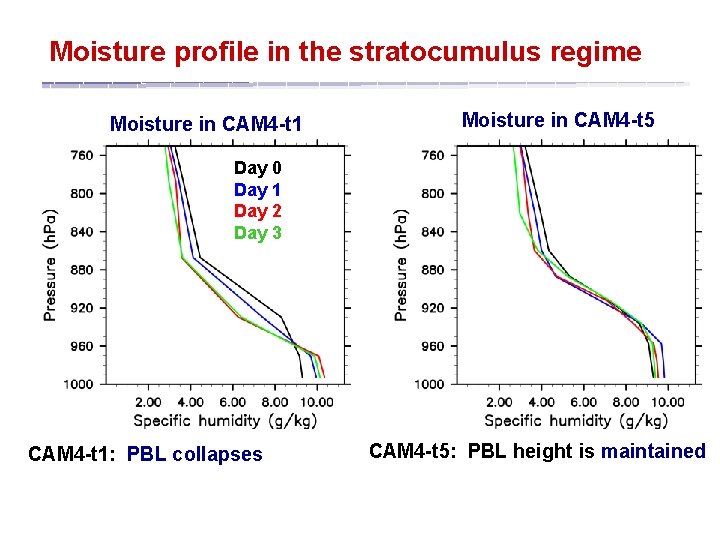
Moisture profile in the stratocumulus regime Moisture in CAM 4 -t 1 Moisture in CAM 4 -t 5 Day 0 Day 1 Day 2 Day 3 CAM 4 -t 1: PBL collapses CAM 4 -t 5: PBL height is maintained
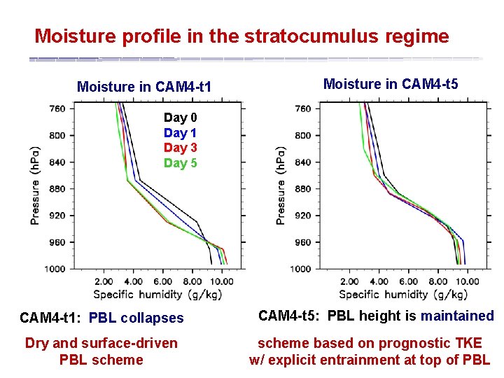
Moisture profile in the stratocumulus regime Moisture in CAM 4 -t 1 Moisture in CAM 4 -t 5 Day 0 Day 1 Day 3 Day 5 CAM 4 -t 1: PBL collapses Dry and surface-driven PBL scheme CAM 4 -t 5: PBL height is maintained scheme based on prognostic TKE w/ explicit entrainment at top of PBL
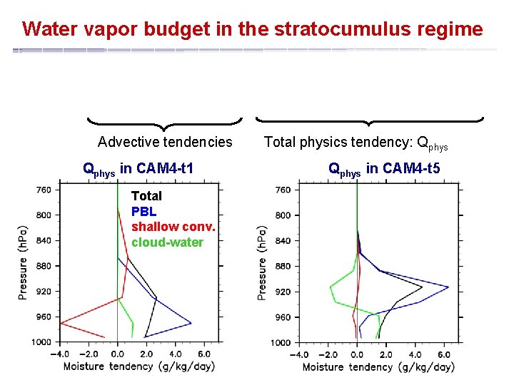
Water vapor budget in the stratocumulus regime Advective tendencies Qphys in CAM 4 -t 1 Total PBL shallow conv. cloud-water Total physics tendency: Qphys in CAM 4 -t 5
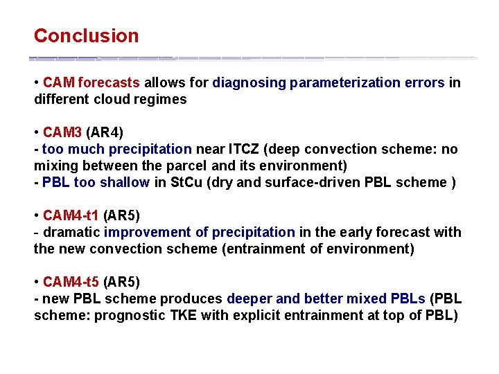
Conclusion • CAM forecasts allows for diagnosing parameterization errors in different cloud regimes • CAM 3 (AR 4) - too much precipitation near ITCZ (deep convection scheme: no mixing between the parcel and its environment) - PBL too shallow in St. Cu (dry and surface-driven PBL scheme ) • CAM 4 -t 1 (AR 5) - dramatic improvement of precipitation in the early forecast with the new convection scheme (entrainment of environment) • CAM 4 -t 5 (AR 5) - new PBL scheme produces deeper and better mixed PBLs (PBL scheme: prognostic TKE with explicit entrainment at top of PBL)
- Slides: 16