Essential Question How do geographers successfully create a


- Slides: 37
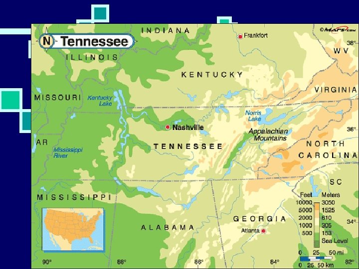
Essential Question How do geographers successfully create a map? 7. 3. spi. 1 identify and use the basic elements of maps and mapping. And 7. 3. spi. 15 interpret a map indicating scale, distance and direction (Bloom’s Taxonomy level 4) Estimated Lesson Length: 2 days Activating Strategy Picture of global cow. Talk about map. Then brainstorm with partner when they have seen/used a map. Teaching Strategies n Introduce vocabulary: (Title, legend/key, compass, index, scale) A fill in the blank sheet is provided for students who need modifications. n. AP #1 Show 5 different maps. Students will pair/share what they believe the maps are and what they show. n G/O Three column chart: First column-what a map should have, second column-purpose, third column-example n Review use of compass and direction. n. Students will complete Direction 1 and Direction 2 activities in pairs. n. AP#2 Use the minefield activity. Students in pairs/small groups will try to navigate through a minefield while blindfolded with assistance from their group. No “words” may be used, only sounds for cardinal directions. n Show www. brainpop. com Map Skills AP#3 Brainpop quiz: Have students answer brainpop questions using whiteboards. Possible Break in lesson-Beginning of Day 2 n. Use of legends/keys in maps. will examine Omey Island map and try to determine what several of the symbols mean. n. Ask “How do you know for sure? ” “What would make this easier? ” Lead them to key. Show elevation map of TN. Ask students how to read map. What does the key tell us? “Why aren’t all keys the same? ” n. AP#4 Compare and Contrast the two maps. n. Scale: Discuss need for scale. Actual distance (straight line) versus travel distance (around the bends). n. Steps to find straight distance n. AP #5 Interpret “Using the Map Scale” n. Show US map with road to NYC from Johnson City. Have students come up with ways to determine the distance. n. Steps to find travel distance. n. AP #6 Interpret “Understanding Road Maps n. AP#7 The Fugitive activity. Students will listen to “The Fugitive” and determine where the fugitive is using the map skills they have practiced. n. Students Summary Out the door/In the door: Create your own island, constructing a map of the island. Include all items from your graphic organizer. Write 3 questions that can be answered by analyzing the map. Homework Options Map skill packet if not finished.
Mapskills How do geographers successfully create a map? 7. 3. spi. 1 and 7. 3. spi. 15
Contents What are maps? Compasses. . . Using Direction Map symbols 4 Figure Grid Refs 6 Figure Grid Refs Finding heights Distance & Scale Describing Routes Practice. .
What are maps? What do you see on the cow? Maps are a way for us to see what the world looks like. It is a method that geographers use to locate different things and to help us find our way from one place to another
Have a brainstorming session with a partner to try and think where you have used a map in the past
Title n Think Language Arts: Just like the title of a passage tells you what it is about, the title of a map tells you what the map is about or referring to.
Compass n The compass shows the directions on a map: north, south, east, and west.
Legend/Key n Maps often have symbols to represent such features as highways, small roads, campgrounds, and rest areas. These symbols are listed in the legend.
Index n The index tells you where to find a specific place on a map. Depending on the size and type of map you're using, the index can help you locate a city, town, or street.
Scale n The scale helps you measure the distance betweeen two places. When you know the distance you can calculate how long the trip will take.
Look at the following 5 maps and write down what and where you think they show
Map 1 is the Mappa Geographica Map 1: Where is this and which is a map of the world and was what does it show? drawn in 1703.
Map 2: Where is this Map 2 is Northern Ireland the map and what does it show? shows the main towns and roads.
Map 3: Where is this and what Map 3 is a Satellite Image of the World taken in 2001. does it show?
Map 4: Where is this and what does it show? Map 4 is a street map of Johnson City, TN.
Map 5: Where is this and what does it show? Map 5 is a map of the tectonic plates.
So, What are maps? Maps are used to help us to represent a place. It allows us to look at the location and surrounding area and environment of a place.
Compasses
Compass roses are used to show the direction of places on maps. This is very important so that we can know how to use the map to move from one place to another.
North West East South NW N NE E W SE SW S Never Wheat Eat Shredded
Using Direction When people move from one place to another they will describe their movement by using the directions that allowed them to travel. To practice this there a few exercises over the next pages to help you to practice your direction-finding skills.
North Use Direction sheet 1 and answer the questions West East South
Use the map below of the major towns in County Antrim to work out the directions between each town. The map and questions can be found on Direction Sheet 2 North West East South
Tim and Moby Time!! n http: //www. brainpop. com/socialstudies/g eography/mapskills/
Déjà vu…. All over again! Mapskills How do geographers successfully create a map? 7. 3. spi. 1 and 7. 3. spi. 15
Why do we use symbols? n When drawing a map to scale it is important to include as much detail as possible – however not all the detail will fit on the map so we have to use a key of different symbols, abbreviations and letters to represent the main items on the map
f
Compare/Contrast
Maps cannot be the same size as the objects are in reality or they would not fit on the page! Therefore we use scale to show the real distances between places by making everything smaller.
If you want to find out the distance between two places on a map there are 2 methods to use. One method looks at the straight line distance (as the crow flies) and the other measures the actual distance, by road, river etc, and usually involves going down bendy lines.
Measuring a straight line distance This is very simple to use. 1. Use your ruler to rule the distance between the 2 places 2. Then compare your answer to the scale of the map (This is usually in the bottom corner of the map and for most maps that you use this will be 1 cm = 50, 000 cm (0. 5 Km)
MAP
Measuring around a bend This is a bit more complicated. You need to use a piece of scrap paper to use to find out the distances. 1. Find the first straight edge and lay the paper down along side the road that you are measuring 2. Mark on the start and end point 3. Find the next straight edge and continue the measurement 4. Continue this until the road is fully measured and then use your ruler and scale to work out the final distance
Describing Routes How did you get here?
It is very important that you learn to use all your skills in using maps to look at a map and think about all of the things that you will pass on your way from one place to another. You must imagine that you are actually taking that route. . .
The Fugitive is a Thinking skills exercise where you will hear a tape of a radio broadcast that takes place following the escape by a known criminal from the local prison. Your job is to use the descriptions o track down where he has got to. . . Use ‘The Fugitive’ sheets