ESCENARIO DE RIESGO IDENTIFICACIN DE PROBABLES LOCALIDADES AFECTADAS

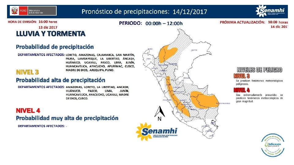
ESCENARIO DE RIESGO IDENTIFICACIÓN DE PROBABLES LOCALIDADES AFECTADAS PRONÓSTICO DE PRECIPITACIONES 13/12/2017 (16: 00 HORAS)

Mapa de exposición alta por INUNDACION Según el Pronóstico de Lluvias Mapa de exposición alta por MOVIMIENTOS EN MASA Según el Pronóstico de Lluvias

Distritos expuestos por Inundación DISTRITOS UCAYALI 2 PASCO 10 MADRE DE DIOS 10 LORETO 8 LIMA 4 50 JUNIN HUANUCO 6 19 HUANCAVELICA CUSCO 5 AYACUCHO 26 AMAZONAS 5 0 10 20 30 40 50 60

Población expuesta por Inundación POBLACIÓN UCAYALI 5, 753 38, 133 PASCO MADRE DE DIOS 92, 249 LORETO 19, 802 95 LIMA JUNIN 517, 582 HUANUCO 1, 262 HUANCAVELICA 17, 965 CUSCO 8, 300 AYACUCHO 8, 041 AMAZONAS 19, 858 0 100, 000 200, 000 300, 000 400, 000 500, 000 600, 000

Distritos expuestos por movimiento en masa DISTRITOS UCAYALI 2 SAN MARTIN 1 17 PASCO MADRE DE DIOS 4 LORETO 3 LIMA 56 LA LIBERTAD 8 JUNIN 96 ICA 1 HUANUCO 51 HUANCAVELICA 71 CUSCO 16 AYACUCHO 61 APURIMAC 2 ANCASH 47 AMAZONAS 12 0 10 20 30 40 50 60 70 80 90 100 110

Población expuesta por Movimientos en Masa POBLACIÓN UCAYALI 559 SAN MARTIN 75 132, 239 PASCO MADRE DE DIOS 2, 329 LORETO 1, 572 LIMA 70, 602 LA LIBERTAD 30, 879 JUNIN 754, 473 ICA 650 HUANUCO 225, 975 HUANCAVELICA 315, 575 CUSCO 62, 891 AYACUCHO 291, 871 APURIMAC 110 ANCASH 147, 614 AMAZONAS 49, 673 0 100, 000 200, 000 300, 000 400, 000 500, 000 600, 000 700, 000 800, 000

Consultas: soporte-sigrid@cenepred. gob. pe
- Slides: 8