ENSO Cycle Recent Evolution Current Status and Predictions
- Slides: 31

ENSO Cycle: Recent Evolution, Current Status and Predictions Update prepared by Climate Prediction Center / NCEP March 8, 2005

Outline • Overview • Recent Evolution and Current Conditions • Oceanic Ni o Index (ONI) – “Revised 1 March 2004” • Pacific SST Outlook • U. S. Seasonal Precipitation and Temperature Outlooks • Summary

Overview • The pattern of warmth in the equatorial Pacific indicates that a weak mid. Pacific warm episode (El Niño) is in progress. • Since the beginning of January 2005 SST departures have decreased throughout the eastern equatorial Pacific, while departures greater than +1 C persisted in the west-central equatorial Pacific (165 E— 170 W). • During February precipitation increased and became more persistent over the anomalously warm west-central equatorial Pacific. • The most recent value of the ONI is +0. 8 (for the period November 2004 January 2005) and the most recent 5 -month running mean value (October 2004 February 2005) of the Southern Oscillation Index (SOI) is – 1. 2. Both are consistent in indicating continued warm episode conditions. • Based on statistical and coupled model forecasts it seems most likely that the warm episode will weaken during the next three months and that ENSO-neutral conditions will prevail during the last half of 2005.

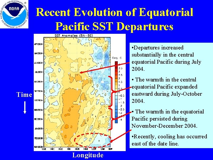
Recent Evolution of Equatorial Pacific SST Departures • Departures increased substantially in the central equatorial Pacific during July 2004. • The warmth in the central equatorial Pacific expanded eastward during July-October 2004. Time • The warmth in the equatorial Pacific persisted during November-December 2004. • Recently, cooling has occurred east of the date line. Longitude

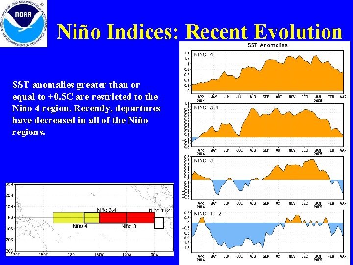
Niño Indices: Recent Evolution SST anomalies greater than or equal to +0. 5 C are restricted to the Niño 4 region. Recently, departures have decreased in all of the Niño regions.

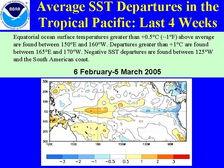
Average SST Departures in the Tropical Pacific: Last 4 Weeks Equatorial ocean surface temperatures greater than +0. 5°C (~1°F) above average are found between 150°E and 160°W. Departures greater than +1°C are found between 165°E and 170°W. Negative SST departures are found between 125°W and the South American coast. 6 February-5 March 2005

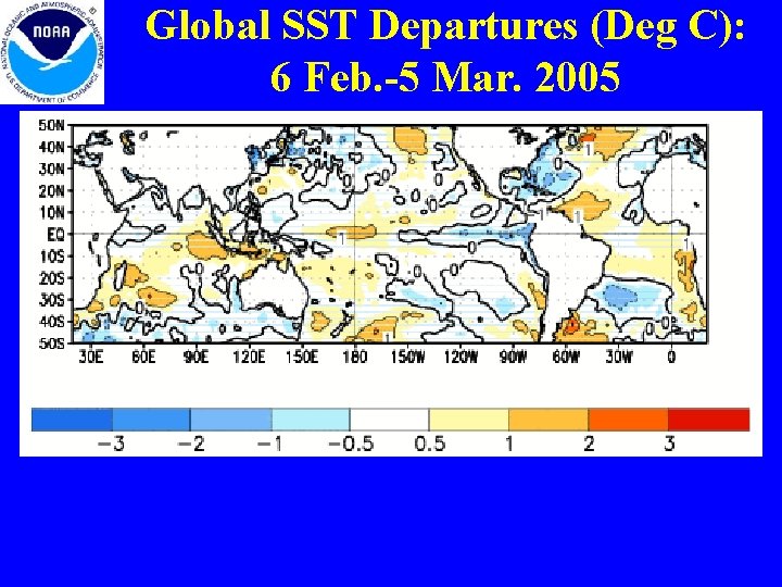
Global SST Departures (Deg C): 6 Feb. -5 Mar. 2005

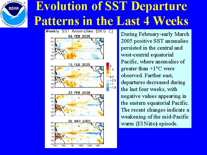
Evolution of SST Departure Patterns in the Last 4 Weeks During February-early March 2005 positive SST anomalies persisted in the central and west-central equatorial Pacific, where anomalies of greater than +1°C were observed. Farther east, departures decreased during the last four weeks, with negative values appearing in the eastern equatorial Pacific. The recent changes indicate a weakening of the mid-Pacific warm (El Niño) episode.

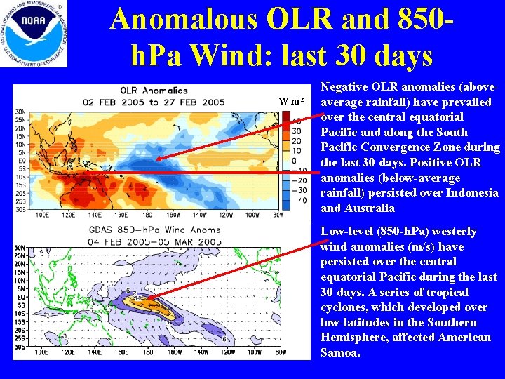
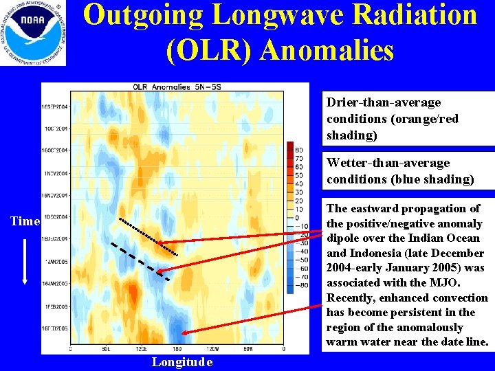
Anomalous OLR and 850 h. Pa Wind: last 30 days W m-2 Negative OLR anomalies (aboveaverage rainfall) have prevailed over the central equatorial Pacific and along the South Pacific Convergence Zone during the last 30 days. Positive OLR anomalies (below-average rainfall) persisted over Indonesia and Australia Low-level (850 -h. Pa) westerly wind anomalies (m/s) have persisted over the central equatorial Pacific during the last 30 days. A series of tropical cyclones, which developed over low-latitudes in the Southern Hemisphere, affected American Samoa.

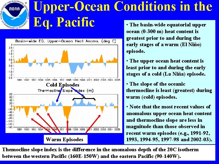
Upper-Ocean Conditions in the • The basin-wide equatorial upper Eq. Pacific ocean (0 -300 m) heat content is greatest prior to and during the early stages of a warm (El Niño) episode. • The upper ocean heat content is least prior to and during the early stages of a cold (La Niña) episode. Cold Episodes Warm Episodes • The slope of the oceanic thermocline is least (greatest) during warm (cold) episodes. • Note that the most recent values of anomalous upper ocean heat content and thermocline slope are less in magnitude than those observed in recent warm episodes (e. g. , 1991 -92, 1993, 1994 -95, 1997 -98 and 2002 -03). Themocline slope index is the difference in the anomalous depth of the 20 C isotherm between the western Pacific (160 E-150 W) and the eastern Pacific (90 -140 W).

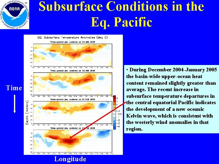
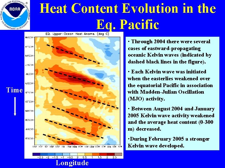
Subsurface Conditions in the Eq. Pacific • During December 2004 -January 2005 the basin-wide upper-ocean heat content remained slightly greater than average. The recent increase in subsurface temperature departures in the central equatorial Pacific indicates the development of a new oceanic Kelvin wave, which is consistent with the westerly wind anomalies in that region. Time Longitude

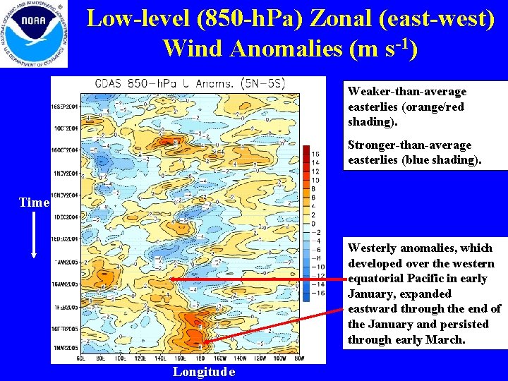
MJO Intraseasonal Variability • MJO activity during June-October and December 2004 -January 2005 resulted in significant variability in the atmosphere (wind and pressure) and Pacific Ocean (surface and subsurface temperature). • Related to this activity – significant weakening of the low-level easterly winds occurred over the equatorial Pacific during late Juneearly July 2004, late August-early September 2004, October 2004 and January 2005. – Each of these events initiated eastward-propagating oceanic Kelvin waves.

Heat Content Evolution in the Eq. Pacific • Through 2004 there were several cases of eastward-propagating oceanic Kelvin waves (indicated by dashed black lines in the figure). • Each Kelvin wave was initiated when the easterlies weakened over the equatorial Pacific in association with Madden-Julian Oscillation (MJO) activity. Time • Between August 2004 and January 2005 Kelvin wave activity weakened and the average heat content (0 -300 m) decreased. • During February 2005 a stronger Kelvin wave developed. Longitude

Low-level (850 -h. Pa) Zonal (east-west) Wind Anomalies (m s-1) Weaker-than-average easterlies (orange/red shading). Stronger-than-average easterlies (blue shading). Time Westerly anomalies, which developed over the western equatorial Pacific in early January, expanded eastward through the end of the January and persisted through early March. Longitude

Outgoing Longwave Radiation (OLR) Anomalies Drier-than-average conditions (orange/red shading) Wetter-than-average conditions (blue shading) The eastward propagation of the positive/negative anomaly dipole over the Indian Ocean and Indonesia (late December 2004 -early January 2005) was associated with the MJO. Recently, enhanced convection has become persistent in the region of the anomalously warm water near the date line. Time Longitude

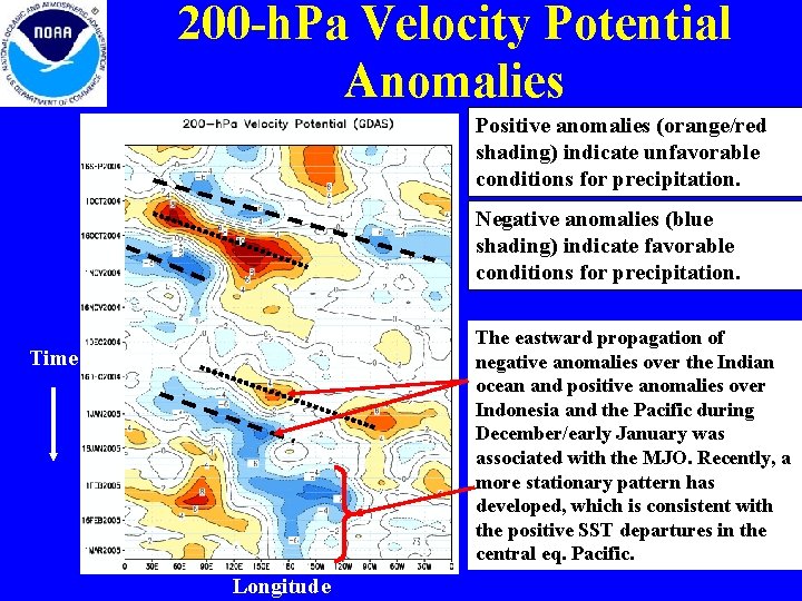
200 -h. Pa Velocity Potential Anomalies Positive anomalies (orange/red shading) indicate unfavorable conditions for precipitation. Negative anomalies (blue shading) indicate favorable conditions for precipitation. The eastward propagation of negative anomalies over the Indian ocean and positive anomalies over Indonesia and the Pacific during December/early January was associated with the MJO. Recently, a more stationary pattern has developed, which is consistent with the positive SST departures in the central eq. Pacific. Time Longitude

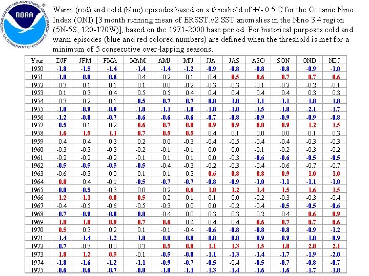
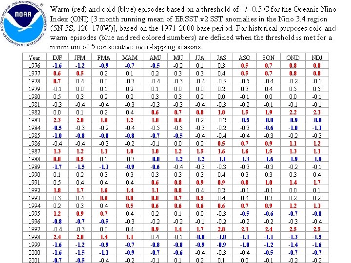
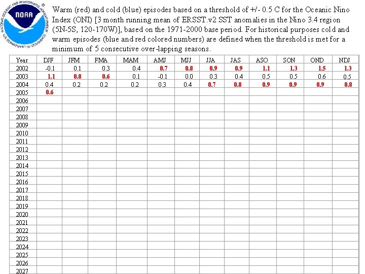
Oceanic Niño Index (ONI) • Based on the principal measure for monitoring, assessment, and prediction of ENSO (SST departures from average in the Niño 3. 4 region) • Three-month running-mean values of SST departures from average in the Niño 3. 4 region, based on a set of improved homogeneous historical SST analyses (Extended Reconstructed SST – ERSST. v 2). The methodology is described in Smith and Reynolds, 2003, J. Climate, 16, 1495 -1510. • Used to place current conditions in historical perspective • NOAA operational definitions of El Niño and La Niña are keyed to the index.

NOAA Operational Definitions for El Niño and La Niña El Niño: characterized by a positive ONI greater than or equal to +0. 5°C. La Ni a: characterized by a negative ONI less than or equal to 0. 5°C. To be classified as a full-fledged El Niño or La Niña episode these thresholds must be exceeded for a period of at least 5 consecutive months.

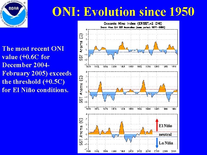
ONI: Evolution since 1950 The most recent ONI value (+0. 6 C for December 2004 February 2005) exceeds the threshold (+0. 5 C) for El Niño conditions. El Niño neutral La Niña

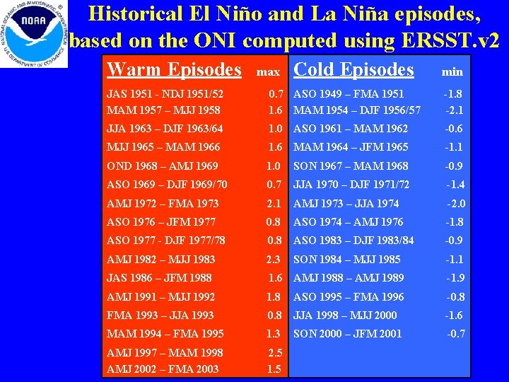
Historical El Niño and La Niña episodes, based on the ONI computed using ERSST. v 2 Warm Episodes max Cold Episodes min JAS 1951 - NDJ 1951/52 MAM 1957 – MJJ 1958 0. 7 ASO 1949 – FMA 1951 1. 6 MAM 1954 – DJF 1956/57 -1. 8 -2. 1 JJA 1963 – DJF 1963/64 1. 0 ASO 1961 – MAM 1962 -0. 6 MJJ 1965 – MAM 1966 1. 6 MAM 1964 – JFM 1965 -1. 1 OND 1968 – AMJ 1969 1. 0 SON 1967 – MAM 1968 -0. 9 ASO 1969 – DJF 1969/70 0. 7 JJA 1970 – DJF 1971/72 -1. 4 AMJ 1972 – FMA 1973 2. 1 AMJ 1973 – JJA 1974 -2. 0 ASO 1976 – JFM 1977 0. 8 ASO 1974 – AMJ 1976 -1. 8 ASO 1977 - DJF 1977/78 0. 8 ASO 1983 – DJF 1983/84 -0. 9 AMJ 1982 – MJJ 1983 2. 3 SON 1984 – MJJ 1985 -1. 1 JAS 1986 – JFM 1988 1. 6 AMJ 1988 – AMJ 1989 -1. 9 AMJ 1991 – MJJ 1992 1. 8 ASO 1995 – FMA 1996 -0. 8 FMA 1993 – JJA 1993 0. 8 JJA 1998 – MJJ 2000 -1. 6 MAM 1994 – FMA 1995 1. 3 SON 2000 – JFM 2001 -0. 7 AMJ 1997 – MAM 1998 AMJ 2002 – FMA 2003 2. 5 1. 5

Warm (red) and cold (blue) episodes based on a threshold of +/- 0. 5 C for the Oceanic Nino Index (ONI) [3 month running mean of ERSST. v 2 SST anomalies in the Nino 3. 4 region (5 N-5 S, 120 -170 W)], based on the 1971 -2000 base period. For historical purposes cold and warm episodes (blue and red colored numbers) are defined when the threshold is met for a minimum of 5 consecutive over-lapping seasons. Year 1950 1951 1952 1953 1954 1955 1956 1957 1958 1959 1960 1961 1962 1963 1964 1965 1966 1967 1968 1969 1970 1971 1972 1973 1974 1975 DJF -1. 8 -1. 0 0. 3 0. 1 0. 3 -1. 0 -1. 2 -0. 5 1. 6 0. 4 -0. 3 -0. 2 -0. 5 -0. 6 0. 8 -0. 8 1. 2 -0. 4 -0. 7 1. 0 0. 5 -1. 4 -0. 7 1. 8 -0. 6 JFM -1. 5 -0. 8 0. 1 0. 3 0. 2 -0. 9 -0. 8 -0. 1 1. 5 0. 4 -0. 3 -0. 2 -0. 5 -0. 3 0. 4 -0. 5 1. 1 -0. 5 -0. 9 1. 0 0. 3 -1. 4 -0. 3 1. 2 -1. 6 -0. 6 FMA -1. 4 -0. 6 0. 1 0. 4 -0. 1 -0. 9 -0. 7 0. 2 1. 1 0. 3 -0. 2 -0. 5 0. 0 -0. 1 -0. 3 0. 8 -0. 6 -0. 8 0. 9 0. 2 -1. 2 0. 0 0. 5 -1. 2 -0. 7 MAM -1. 4 -0. 4 0. 1 0. 5 -1. 0 -0. 6 0. 7 0. 2 -0. 1 -0. 5 0. 0 0. 5 -0. 8 0. 7 0. 1 -1. 0 0. 3 -0. 1 -1. 1 -0. 8 AMJ -1. 4 -0. 2 0. 0 0. 5 -0. 7 -1. 1 -0. 6 0. 7 0. 5 0. 0 -0. 1 -0. 4 0. 1 -0. 7 0. 2 -0. 3 -0. 4 0. 6 -0. 1 -0. 8 0. 5 -0. 9 -1. 0 MJJ -1. 2 0. 1 -0. 2 0. 4 -0. 7 -1. 0 -0. 6 0. 8 0. 5 -0. 3 -0. 1 -0. 3 -0. 7 0. 6 0. 1 0. 0 0. 4 -0. 8 -0. 7 -1. 1 JJA -0. 9 0. 4 -0. 3 0. 4 -0. 8 -1. 0 -0. 7 0. 9 0. 4 -0. 4 0. 0 -0. 2 0. 6 -0. 8 1. 0 0. 1 0. 0 0. 3 0. 4 -0. 6 -0. 8 1. 1 -0. 5 -1. 3 JAS -0. 8 0. 5 -0. 3 0. 4 -1. 0 -0. 8 0. 9 0. 1 -0. 5 0. 0 -0. 3 0. 8 -0. 9 1. 2 0. 0 -0. 2 0. 3 0. 4 -0. 8 1. 3 -0. 4 -1. 4 ASO -0. 8 0. 6 -0. 1 0. 4 -1. 1 -1. 5 -0. 9 0. 8 0. 0 -0. 4 -0. 1 -0. 6 -0. 4 0. 8 -1. 0 1. 4 -0. 2 -0. 4 0. 2 0. 6 -0. 8 -0. 9 1. 5 -1. 4 -0. 5 -1. 6 SON -0. 8 0. 7 -0. 2 0. 4 -1. 1 -1. 8 -0. 9 0. 0 -0. 4 -0. 2 -0. 6 0. 9 -1. 1 1. 5 -0. 3 -0. 5 0. 4 0. 7 -0. 8 -0. 9 1. 8 -1. 7 -0. 7 -1. 6 OND -0. 9 0. 7 -0. 2 0. 3 -1. 0 -2. 1 -0. 9 1. 2 0. 1 -0. 3 -0. 5 -0. 7 1. 0 -1. 1 1. 6 -0. 3 -0. 5 0. 6 0. 7 -0. 9 -1. 0 2. 0 -1. 9 -0. 8 -1. 7 NDJ -1. 0 0. 6 -0. 1 0. 3 -1. 0 -1. 7 -0. 8 1. 5 0. 3 -0. 2 -0. 5 -0. 7 1. 0 -1. 0 1. 5 -0. 4 -0. 6 0. 9 0. 6 -1. 2 -0. 9 2. 1 -2. 0 -0. 7 -1. 8

Warm (red) and cold (blue) episodes based on a threshold of +/- 0. 5 C for the Oceanic Nino Index (ONI) [3 month running mean of ERSST. v 2 SST anomalies in the Nino 3. 4 region (5 N-5 S, 120 -170 W)], based on the 1971 -2000 base period. For historical purposes cold and warm episodes (blue and red colored numbers) are defined when the threshold is met for a minimum of 5 consecutive over-lapping seasons. Year 1976 1977 1978 1979 1980 1981 1982 1983 1984 1985 1986 1987 1988 1989 1990 1991 1992 1993 1994 1995 1996 1997 1998 1999 2000 2001 DJF -1. 6 0. 7 -0. 1 0. 5 -0. 3 0. 0 2. 3 -0. 5 -1. 0 -0. 4 1. 3 0. 8 -1. 7 0. 1 0. 5 1. 8 0. 3 0. 2 1. 2 -0. 8 -0. 4 2. 4 -1. 6 -0. 7 JFM -1. 2 0. 5 0. 4 0. 0 0. 3 -0. 4 0. 1 2. 0 -0. 3 -0. 8 -0. 4 1. 2 0. 5 -1. 5 0. 2 0. 4 1. 7 0. 4 0. 3 0. 9 -0. 7 -0. 3 2. 0 -1. 2 -1. 5 -0. 5 FMA -0. 9 0. 2 0. 0 0. 1 0. 2 -0. 4 0. 2 1. 6 -0. 2 -0. 8 -0. 3 1. 1 0. 1 -1. 1 0. 3 0. 4 1. 6 0. 4 0. 7 -0. 5 0. 0 1. 4 -0. 9 -1. 1 -0. 4 MAM -0. 7 0. 1 -0. 3 0. 2 -0. 3 0. 4 1. 2 -0. 4 -0. 8 -0. 2 1. 0 -0. 3 -0. 9 0. 3 0. 4 1. 4 0. 8 0. 5 0. 4 -0. 3 0. 4 1. 1 -0. 7 -0. 9 -0. 2 AMJ -0. 5 0. 2 -0. 4 0. 1 0. 3 -0. 3 0. 6 1. 0 -0. 5 -0. 7 -0. 1 1. 0 -0. 8 -0. 6 0. 3 0. 6 1. 1 0. 8 0. 6 0. 2 -0. 2 0. 9 0. 4 -0. 8 -0. 7 -0. 1 MJJ -0. 2 0. 3 -0. 3 0. 0 0. 3 -0. 3 0. 7 0. 6 -0. 5 0. 0 1. 2 -0. 4 0. 3 0. 8 0. 7 0. 6 0. 1 -0. 2 1. 4 -0. 1 -0. 8 -0. 6 0. 1 JJA 0. 1 0. 3 -0. 4 0. 0 0. 2 -0. 4 0. 8 0. 2 -0. 3 -0. 4 0. 2 1. 5 -1. 2 -0. 3 0. 9 0. 4 0. 5 0. 6 0. 0 -0. 1 1. 7 -0. 8 -0. 9 -0. 4 0. 2 JAS 0. 3 0. 4 -0. 5 0. 2 0. 0 -0. 3 1. 0 -0. 2 -0. 4 0. 5 1. 6 -1. 1 -0. 3 0. 4 0. 9 0. 2 0. 4 0. 6 -0. 3 -0. 2 2. 0 -1. 0 -0. 9 -0. 3 0. 1 ASO 0. 5 -0. 5 0. 3 -0. 1 -0. 2 1. 5 -0. 3 -0. 4 0. 7 1. 6 -1. 3 -0. 3 0. 8 -0. 1 0. 4 0. 7 -0. 5 -0. 2 2. 3 -1. 1 -1. 0 -0. 4 0. 0 SON 0. 7 -0. 4 0. 0 -0. 1 1. 9 -0. 8 -0. 6 -0. 3 0. 9 1. 5 -1. 6 -0. 3 1. 0 -0. 1 0. 3 0. 9 -0. 6 -0. 2 2. 4 -1. 1 -1. 2 -0. 5 -0. 1 OND 0. 8 -0. 2 0. 5 0. 0 -0. 1 2. 2 -0. 9 -1. 0 -0. 2 1. 1 1. 3 -1. 9 -0. 2 0. 3 1. 4 0. 0 0. 2 1. 2 -0. 7 -0. 3 2. 5 -1. 3 -1. 4 -0. 7 -0. 2 NDJ 0. 8 -0. 1 0. 5 -0. 1 2. 3 -0. 8 -1. 1 -0. 3 1. 2 1. 1 -1. 9 -0. 1 0. 4 1. 7 0. 1 0. 2 1. 3 -0. 8 -0. 4 2. 5 -1. 6 -0. 7 -0. 2

Warm (red) and cold (blue) episodes based on a threshold of +/- 0. 5 C for the Oceanic Nino Index (ONI) [3 month running mean of ERSST. v 2 SST anomalies in the Nino 3. 4 region (5 N-5 S, 120 -170 W)], based on the 1971 -2000 base period. For historical purposes cold and warm episodes (blue and red colored numbers) are defined when the threshold is met for a minimum of 5 consecutive over-lapping seasons. Year 2002 2003 2004 2005 2006 2007 2008 2009 2010 2011 2012 2013 2014 2015 2016 2017 2018 2019 2020 2021 2022 2023 2024 2025 2026 2027 DJF -0. 1 1. 1 0. 4 0. 6 JFM 0. 1 0. 8 0. 2 FMA 0. 3 0. 6 0. 2 MAM 0. 4 0. 1 0. 2 AMJ 0. 7 -0. 1 0. 3 MJJ 0. 8 0. 0 0. 4 JJA 0. 9 0. 3 0. 7 JAS 0. 9 0. 4 0. 8 ASO 1. 1 0. 5 0. 9 SON 1. 3 0. 5 0. 9 OND 1. 5 0. 6 0. 9 NDJ 1. 3 0. 5 0. 8

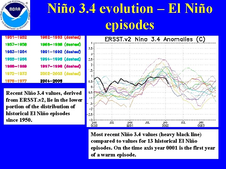
Niño 3. 4 evolution – El Niño episodes Recent Niño 3. 4 values, derived from ERSST. v 2, lie in the lower portion of the distribution of historical El Niño episodes since 1950. Most recent Niño 3. 4 values (heavy black line) compared to values for 13 historical El Niño episodes. On the time axis year 0001 is the first year of a warm episode.

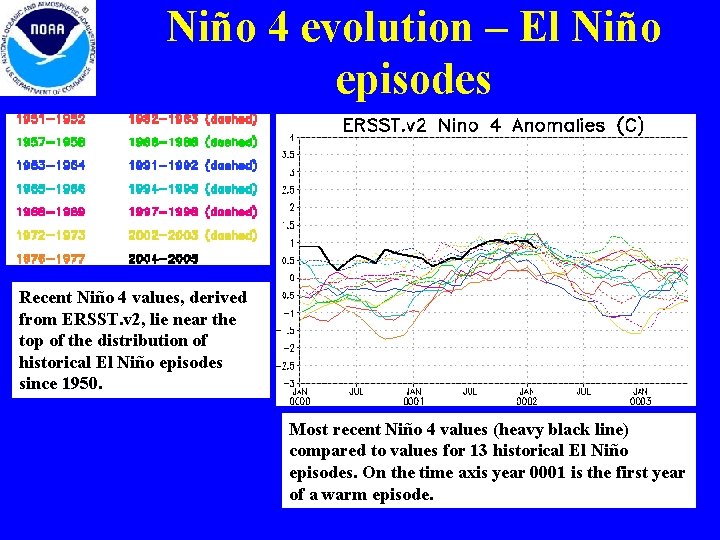
Niño 4 evolution – El Niño episodes Recent Niño 4 values, derived from ERSST. v 2, lie near the top of the distribution of historical El Niño episodes since 1950. Most recent Niño 4 values (heavy black line) compared to values for 13 historical El Niño episodes. On the time axis year 0001 is the first year of a warm episode.

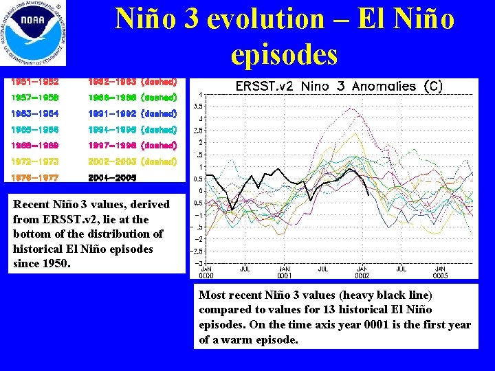
Niño 3 evolution – El Niño episodes Recent Niño 3 values, derived from ERSST. v 2, lie at the bottom of the distribution of historical El Niño episodes since 1950. Most recent Niño 3 values (heavy black line) compared to values for 13 historical El Niño episodes. On the time axis year 0001 is the first year of a warm episode.

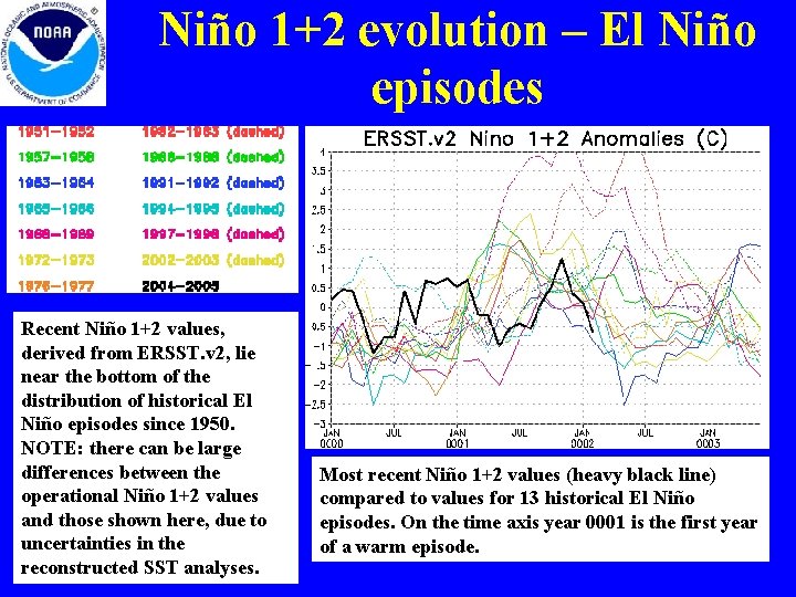
Niño 1+2 evolution – El Niño episodes Recent Niño 1+2 values, derived from ERSST. v 2, lie near the bottom of the distribution of historical El Niño episodes since 1950. NOTE: there can be large differences between the operational Niño 1+2 values and those shown here, due to uncertainties in the reconstructed SST analyses. Most recent Niño 1+2 values (heavy black line) compared to values for 13 historical El Niño episodes. On the time axis year 0001 is the first year of a warm episode.

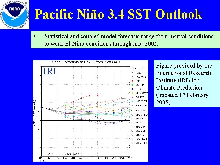
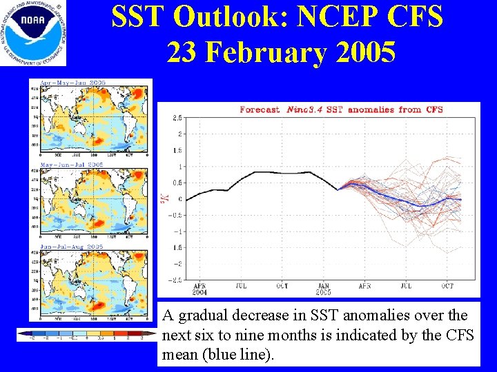
Pacific Niño 3. 4 SST Outlook • Statistical and coupled model forecasts range from neutral conditions to weak El Niño conditions through mid-2005. Figure provided by the International Research Institute (IRI) for Climate Prediction (updated 17 February 2005).

SST Outlook: NCEP CFS 23 February 2005 A gradual decrease in SST anomalies over the next six to nine months is indicated by the CFS mean (blue line).

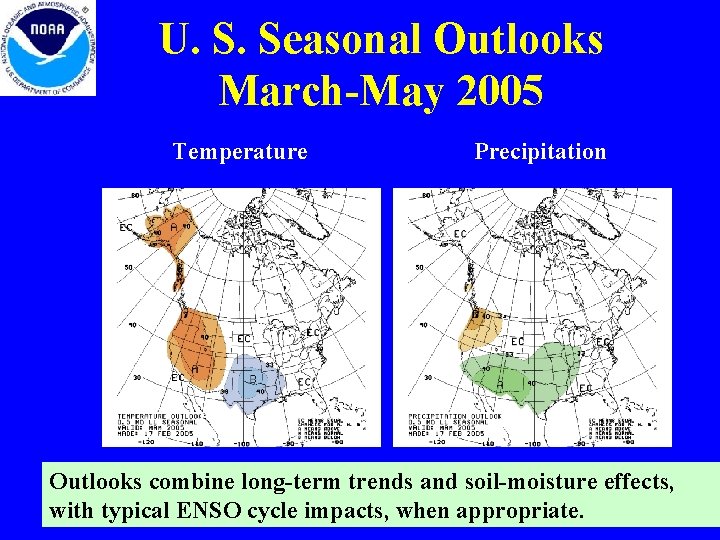
U. S. Seasonal Outlooks March-May 2005 Temperature Precipitation Outlooks combine long-term trends and soil-moisture effects, with typical ENSO cycle impacts, when appropriate.

Summary • The pattern of warmth in the equatorial Pacific indicates that a weak mid. Pacific warm episode (El Niño) is in progress. • Since the beginning of January 2005 SST departures have decreased throughout the eastern equatorial Pacific, while departures greater than +1 C persisted in the west-central equatorial Pacific (165 E— 170 W). • During February precipitation increased and became more persistent over the anomalously warm west-central equatorial Pacific. • The most recent value of the ONI is +0. 8 (for the period November 2004 January 2005) and the most recent 5 -month running mean value (October 2004 February 2005) of the Southern Oscillation Index (SOI) is – 1. 2. Both are consistent in indicating continued warm episode conditions. • Based on statistical and coupled model forecasts it seems most likely that the warm episode will weaken during the next three months and that ENSO-neutral conditions will prevail during the last half of 2005.