ENQUIRY 1 Starter Draw the hydrological cycle Indicate


")


 Geology Surface drainage occurs on rocks which are impermeable such as granite and")


- Slides: 14
ENQUIRY 1 Starter: Draw the hydrological cycle Indicate what the drivers are and where they occur
Match up the definition with the key term
THE HYDROLOGICAL SYSTEM The hydrological system (global values)
1. On your diagram of the hydro cycle, shade it in then explain how the hydro cycle works and how it explains global water supplies. 2. Then explain the influence of climate, river systems and geology on global fresh water supply – use the next slide.
1. The geography of water supply and demand – EXPLAIN! • River systems transport this water, often at continental scale. • Flows increase downstream as tributaries enter. • Seasonal changes in temperature can create distinctive river regimes. • The relationship between water inputs and outputs is water balance Climate • Climatic zones are critical in determining water availability • Equatorial / tropical areas have higher rainfall than temperate / arctic areas. • High altitude areas have snowpack water reserves released in late spring. • Monsoon areas have one main peak, equatorial areas two peaks. • Some tropical areas experience recurring drought Geology • Surface drainage occurs on rocks which are impermeable such as granite and clay. • Permeable rocks like limestone, chalk and some sandstones store water, called aquifers. Physical influences on water supply and scarcity 97. 2% Ocean & saltwater
Climate WHY WOULD RIVER REGIMES DIFFER IN DISCHARGE? Geology Soils
RIVER REGIMES VARY AND SO DOES WATER SUPPLY
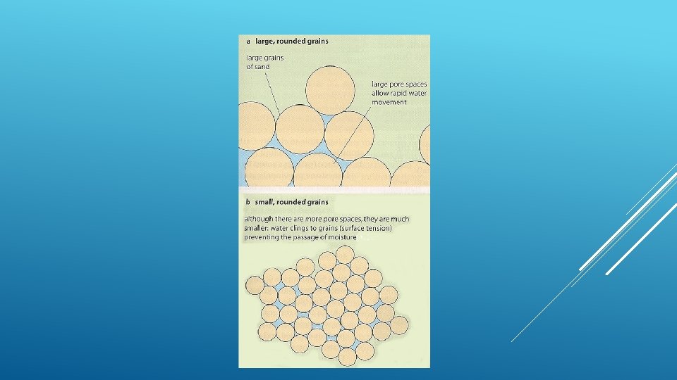
c) Geology Surface drainage occurs on rocks which are impermeable such as granite and clay Permeable rocks like chalk and some sandstones store water The rate of infiltration of water into the soil or of percolation into rocks depends on the porosity and permeability of the material. Sand has large pores and this allows water to infiltrate quickly at a rate of about 200 mm/hr whilst in clay the rate is only about 5 mm/hour. Both materials are porous (the % of the material that is air spaces or pores) but the sand is much more permeable. • [Perviousness is where water can drain through cracks in the rock – limestone is a pervious rock with many joints and bedding planes]. • Soil water is important because it affects upward and downward movement of water (and dissolved nutrients). Drainage depends on the balance between the water retention capacity (water storage In the soil) and the infiltration rate. This is controlled by the porosity and permeability of the soil. Clays have many micropores which can retain water for long periods – giving it a high water retention capacity but reducing its infiltration rate. Sands have fewer but much larger macropores which permit more rapid infiltration.
GEOLOGY 1. Impermeable Rocks = High Drainage density 2. Permeable rocks = water passes under ground 3. Aquifers e. g chalk
What are the 6 key controls that affect drainage basins and therefore the shape of a hydrographs Drainage density Basin size, shape and relief vegetation HYDROGRAPHS soil
USING YOUR PLCS AND YOUR NOTES CREATE 3 AND 6 MARK QUESTIONS
PLENARY: WATER QUIZZES HTTP: //NEWS. BBC. CO. UK/1/HI/SCI/TEC H/3747588. STM http: //www. surfnetkids. com/games/watercycleqm. htm