Engineering Geology Ground Water Dr Prabha Joshi Department

Engineering Geology: Ground Water Dr. Prabha Joshi Department: B. E. Civil Engineering Subject: Engineering Geology Semester: III Teaching Aids Service by KRRC Information Section

Remember the Water Cycle… http: //ga. water. usgs. gov/edu/watercyclegraphichi. html

Where is the Water? • 97% water is salt water in oceans • 3% is fresh water – 67% of this is snow & ice only 1% of global water is accessible • 98% of accessible water is groundwater • 2% of accessible water is surface water – Humid climates: 40% of PPT groundwater – Mediterranean: 10 -20% groundwater – Arid/semi-arid: <1% groundwater

Background • Groundwater: Water that occurs in saturated zones beneath the soil surface. • the water that lies beneath the ground surface, filling the pore space between grains in bodies of sediment and clastic sedimentary rock, and filling cracks and crevices in all types of rock. • source of ground water is rain and snow that falls to the ground a portion of which percolates down into the ground to become ground water

• The Basics • Infiltration: downward movement of water into soil under the influence of gravity. • Percolation: movement of water in the saturated zone under the influence of hydrostatic head.

Sources of Groundwater • Meteoric water: it is the water derived from precipitation. • Connate water: this is the water preset in the rock right from the time of their deposition in an aqueous environment. It is commonly saline in nature. • Juvenile Water: It is also called magmatic water, It is the water formed in crevices or cracks or pores of rocks by condensation of the steam emanating from hot molten masses. It is of only theoretical importance.

Understanding the system • Zone of aeration: Soil surface water table top – Soil water zone • Soil surface through the root zone – Vadose zone • Soil water zone capillary fringe – Capillary fringe: • Water from saturated zone is pulled up • Zone of saturation: below the water table

The Water Table • Saturated zone: the subsurface zone in which all rock openings are filled with water. • Water table: the upper surface of the zone of saturation. • Vadose zone: a subsurface zone in which rock openings are generally unsaturated and filled partly with air and partly with water; above the saturated zone. • Capillary fringe: a transition zone with higher moisture content at the base of the vadose zone just above the water table.

The Water Table

The Water Table • Perched water table: the top of a body of ground water separated from the main water table beneath it by a zone that is not saturated.

The Movement of Ground Water • most ground water moves relatively slowly through rock underground • because it moves in response to differences in water pressure and elevation, water within the upper part of the saturated zone tends to move downward following the slope of the water table. Movement of ground water beneath a sloping water table in uniformly permeable rock. Near the surface the ground water tends to flow parallel to the sloping water table

Discussion • Can the zone of aeration be saturated? – Yes, but only temporarily • Is the water table static (does it move)? – Yes, in response to ppt, management • What are effluent streams? – Perennial; grazing streams; fed by groundwater • What are influent streams? – Losing streams; stream groundwater
 (from Keller, 2000, Figure 10. 5 a) • Water table is")
Perennial Stream (effluent) (from Keller, 2000, Figure 10. 5 a) • Water table is higher than the water level in the stream. • Humid climate • Flows all year -- fed by groundwater base flow (1) • Discharges groundwater S. Hughes, 2003
 (from Keller, 2000, Figure 10. 5 b) • Water table is")
Ephemeral Stream (influent) (from Keller, 2000, Figure 10. 5 b) • Water table is lower than the water level in the stream. • Semiarid or arid climate • Flows only during wet periods (flashy runoff) • Recharges groundwater S. Hughes, 2003
 = fraction")
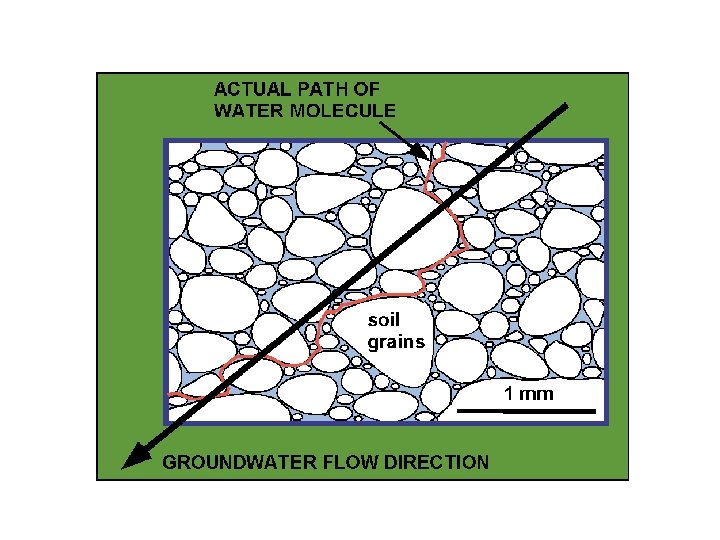
Groundwater Movement POROSITY = F or n (units - fraction or %) = fraction of void space (empty space) in soil or rock. Represents the path water molecules can follow in the subsurface Primary porosity - intergranular Secondary porosity - fractures, faults, cavities, etc. Porosity = volume of pore space relative to the total volume (rock and/or sediment + pore space). Primary porosity (% pore space) is the initial void space present (intergranular) when the rock formed. Secondary porosity (% added by openings) develops later. It is the result of fracturing, faulting, or dissolution. Grain shape and cementation also affect porosity. S. Hughes, 2003
 POORLY SORTED Coarse - Fine WELL SORTED Fine (silt-clay) Permeability")
WELL SORTED Coarse (sand-gravel) POORLY SORTED Coarse - Fine WELL SORTED Fine (silt-clay) Permeability and Hydraulic Conductivity High Low Sorting of material affects groundwater movement. Poorly sorted (well graded) material is less porous than well-sorted material. S. Hughes, 2003

• Porosity: total void space in rock or soil as volume – 10% for glacial till – 20 -50% for sands and gravels – 33 -60% for clays • Effective porosity: ratio of void space through which water can flow to the total volume • Permeability: Degree of connectedness of the pores

Groundwater Movement PERMEABILITY is the capability of a rock to allow the passage of fluids. Permeability is dependent on the size of pore spaces and to what degree the pore spaces are connected. Grain shape, grain packing, and cementation affect permeability. SPECIFIC YIELD (Sy) The quantity of water that a unit volume of aquifer drains by gravity. is the ratio of the volume of water drained from a rock (due to gravity) to the total rock volume. Grain size has a definite effect on specific yield. Smaller grains have larger surface area/volume ratio, which means more surface tension. Fine-grained sediment will have a lower Sy than coarse-grained sediment.
 is the ratio of the volume of water a")
• SPECIFIC RETENTION (Sr) is the ratio of the volume of water a rock can retain (in spite of gravity) to the total volume of rock. • Specific yield plus specific retention equals porosity (often designated with the Greek letter phi):

Water Bearing Qualities of Rocks • Aquifer: water-bearing porous soil or rock strata that yield significant water to wells or through which water can move easily. • good aquifers include sandstone, conglomerate, well-jointed limestone, bodies of sand gravel, and some fragmental or fractured volcanic rocks such as columnar basalt

• Aquiclude: any water-bearing soil or rock that may be porous enough to hold good quantity of water but being effectively impermeable they do not allow and easy or quick flow through it. – Example: shale, slate, clays • Aquifuge: It is absolutely an impermeable formation through which there is no possibility of storage or movement of water-bearing soil or rock that retards flow of groundwater. – Example: compact interlocking granites, quartzites, silts, mudstones • Aquitard: It s a less common term used for an aquifuge or aquitclude that has become locally leaky due to development of joints or cracks

Types of aquifers • Unconfined aquifer: a partially filed aquifer exposed to the land surface and marked by a rising and falling water table. water is in direct contact with the atmosphere through porous material – Allows for transfer of gases and water
: an aquifer completely filled with pressurized")
Types of aquifers • Confined aquifer (artesian aquifer): an aquifer completely filled with pressurized water and separated from the land surface by a relatively impermeable bed, such as shale. – Also called artesian; these are under pressure

• Sometimes a lens of non-permeable material will be found within more permeable material. Water percolating through the unsaturated zone will be intercepted by this layer and will accumulate on top of the lens. This water is a perched aquifer. • Perched: bottom of the aquifer is constrained by an aquitard • Perched water table: the top of a body of ground water separated from the main water table beneath it by a zone that is not saturated

Unconfined Vs. Confined Piezometric or potentiometric surface: The level to which the water in an artesian aquifer would rise if unaffected by friction with the surrounding rocks and sediments.

Summary of Groundwater Systems NOTE: Study each term, and the associated concepts and geologic processes. (from Keller, 2000, Figure 10. 9) S. Hughes, 2003

Groundwater -- Artesian Conditions • Water pressure in buildings is maintained by a hydraulic head (h) and confinement of water beneath the pressure surface. • Natural artesian conditions occur when an aquifer is confined by a saturated, impermeable clay layer (aquitard or aquiclude) below the sloping pressure surface. • An artesian well flows continually. It is produced when a well penetrates the clay layer and the land surface is below the pressure surface. (from Keller, 2000, Figure 10. 7) S. Hughes, 2003

A cone of depression occurs in an aquifer when groundwater is pumped from a well. In an unconfined aquifer (water table), this is an actual depression of the water levels. In confined aquifers (artesian), the cone of depression is a reduction in the pressure head surrounding the pumped well. When a well is pumped, the water level in the well is lowered. By lowering this water level, a gradient occurs between the water in the surrounding aquifer and the water in the well. Because water flows from high to low water levels or pressure, this gradient produces a flow from the surrounding aquifer into the well. As the water flows into the well, the water levels or pressure in the aquifer around the well decrease. The amount of this decline becomes less with distance from the well, resulting in a cone-shaped depression radiating away from the well.

Use of Cone of Depression • Cones of depression can be really useful when dealing with contaminant plumes in ground water. Often, a well can be placed near a contaminant plume and pumped at a sufficient rate to create a cone of depression. • This cone of depression can act to capture the contaminant flow (essentially pulling it out of the aquifer). The pumped water can then be treated. The use of capture wells has been helpful in protecting water supply wells and for isolating contaminants near spills, landfills, and other sources.
 Water table")
Groundwater Movement -- Cone of Depression (from Keller, 2000, Figure 10. 10) Water table flow Cone of depression Pumping water from a well causes a cone of depression to form in the water table at the well site. S. Hughes, 2003

Where do I find Groundwater? • Groundwater resource improve as you go from highlands to floodplains and basins – Best bet: major river valleys, alluvial plains – Look for ancient alluvium – High variability, even locally

Springs and Streams • Spring: a place where water flows naturally from rock onto the land surface. • some springs discharge where the water table intersects the land surface, but they also occur where water flows out from caverns or along fractures, faults, or rock contacts that come to the surface Water enters caves along joints in limestone and exits as springs at the mouths of caves Water moves along fractures in crystalline rock and forms springs where the fractures intersect the land surface Springs can form along faults when permeable rock has been moved against less permeable roc Arrows show relative motion along fault Springs form at the contact between a permeable rock such as sandstone and an underlying less permeable rock such as shale

Springs and Streams • Gaining stream: a stream that receives water from the zone of saturation • Losing stream: a stream that looses water to the zone of saturation Stream gaining water from saturated zone Stream losing water through stream bed to saturated zone Water table can be close to the land surface beneath a dry stream bed
: naturally formed underground chamber • most")
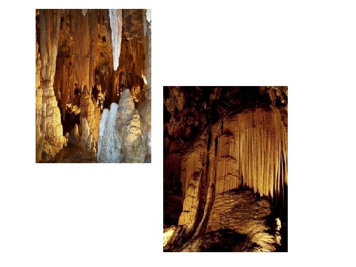
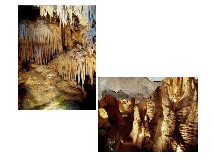
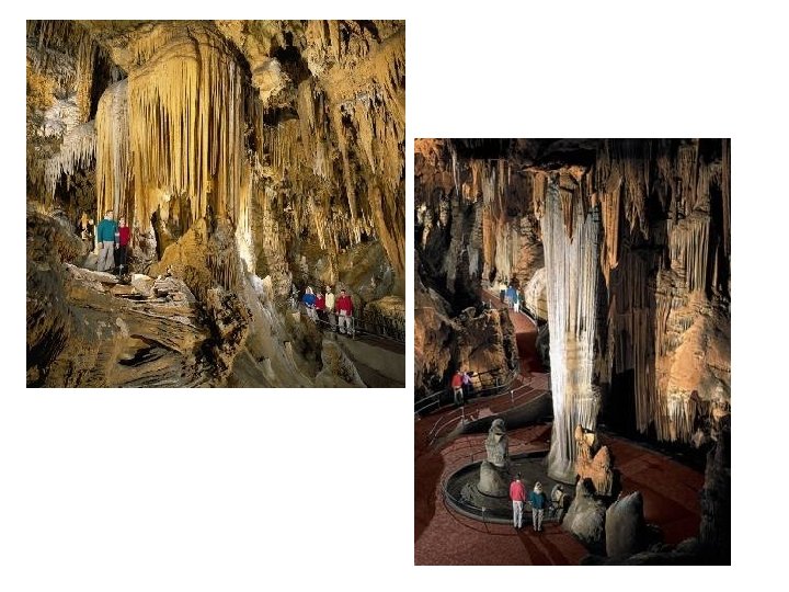
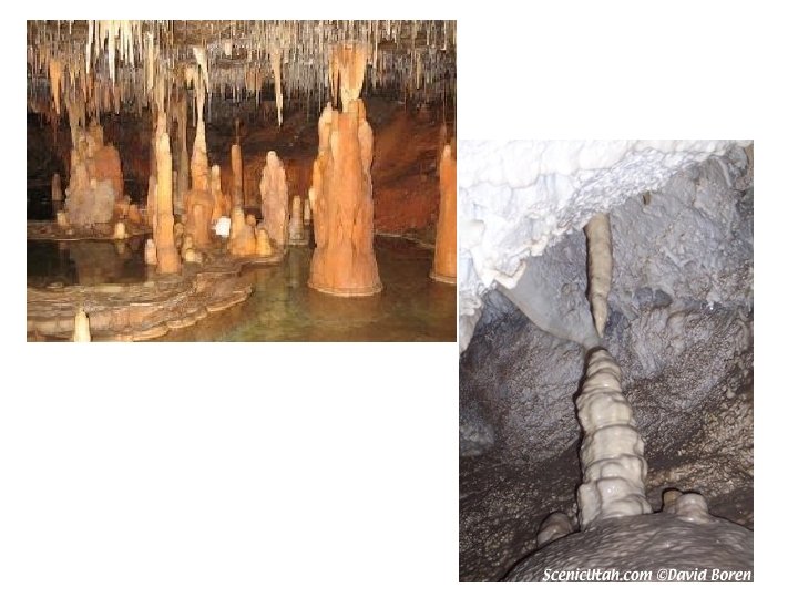
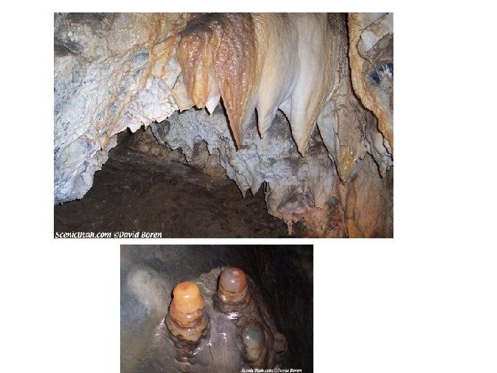
Effects of Ground-Water Action • Caves (or caverns): naturally formed underground chamber • most caves develop when slightly acidic ground water dissolves limestone along joints and bedding planes, opening up cavern systems as calcite is carried away in solution. • most caves probably are formed by ground water circulating below the water table H 2 O + CO 2 + Ca. CO 3 Ca++ + 2 HCO 3 water carbon dioxide calcite in limestone calcium ion bicarbonate ion development of caves (solution) development of flowstone and dripstone (precipitation)

This solution travels through the rock until it reaches an edge and if this is on the roof of cave it will drip down. When the solution comes into contact with air the chemical reaction that created it is reversed and particles of calcium carbonate are deposited. The reversed reaction is. Ca(HCO 3)2 → Ca. CO 3 + H 2 O + CO 2

Effects of Ground-Water Action • Stalactites: icicle-like pendants of dripstone hanging from cave ceilings, generally slender and are commonly aligned along cracks in the ceiling, which act as conduits for ground water • Stalagmites: cone-shaped masses of drip-stone formed on cave floors, generally directly below stalactites Water moves along fractures and bedding planes in limestone, dissolving the limestone to form caves below the water table Falling water table allows cave system, now greatly enlarged, to fill with air. Calcite precipitation forms stalactites, stalagmites, and columns above the water table

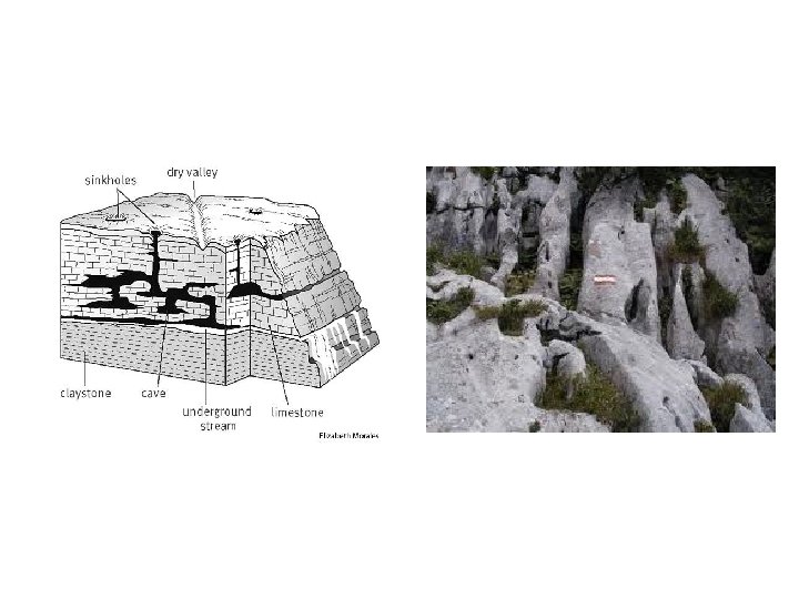
Effects of Ground-Water Action • Sinkholes: closed depressions found on land surfaces underlain by limestone; they form either by the collapse of a cave roof or by solution as descending water enlarges a crack in limestone A collapse sinkhole that formed suddenly in Winter Park, Florida, in 1981 Trees grow in a sinkhole formed in limestone near Mammoth Cave, Kentucky

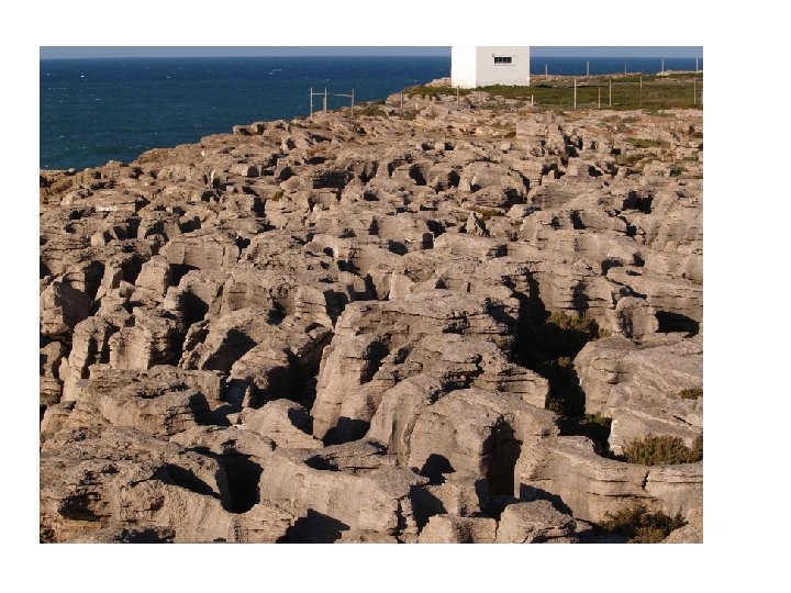
Effects of Ground-Water Action • Karsts topography: an area with many sinkholes and with cave systems beneath the land surface, a name derived from a famous cave region along the Adriatic Sea in Italy and Slovenia. " Cave ". Karst topography is marked by underground caves and numerous surface sinkholes. A major river may cross the region, but small surface streams generally disappear down sinkholes
 • petrified wood: develops when porous buried wood")
Effects of Ground-Water Action (cont. ) • petrified wood: develops when porous buried wood is either filled in or replaced by inorganic silica carried in by ground water • Concretion: a hard, round mass that develops when a considerable amount of cementing material precipitates locally in a rock, often around an organic nucleus • geodes: partly hollow, globe-shaped bodies found in some limestones and locally in other rocks Petrified log Concretions that have weathered out of shale Geodes

Hot Water Underground • Hot springs: springs in which the water is warmer than human body temperature • water can gain heat in two ways while underground: • ground water may circulate near a magma chamber or a body of cooling igneous rock • ground water may circulate unusually deep in the earth
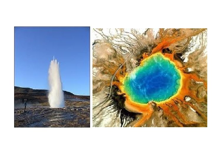

Hot Water Underground • geyser: a type of hot spring that periodically erupts hot water and stream; the water is generally near boiling (100 o. C) 1 3 2 4

Hot Water Underground • geyser: a type of hot spring that periodically erupts hot water and stream; the water is generally near boiling (100 o. C) 1 3 2 4

Geothermal Energy • Electricity can be generated by harnessing naturally occurring stream and hot water in areas that are exceptionally hot underground (geothermal areas); • nonelectric uses of geothermal energy include space heating, as well as paper manufacturing, ore processing, and food preparation
- Slides: 52