Emergency Radio Beacons General Information Norway has been

Emergency Radio Beacons

General Information Norway has been a pioneer country in the maritime sector and was among the very first to develop emergency beacons for Norwegian ships. This came largely as a result of several ship wrecks from which no distress signals were received. n Aeronautical Beacons were the first beacon using frequencies 121. 5 and 243 MHz but were only monitored by civilian and military aircraft. n

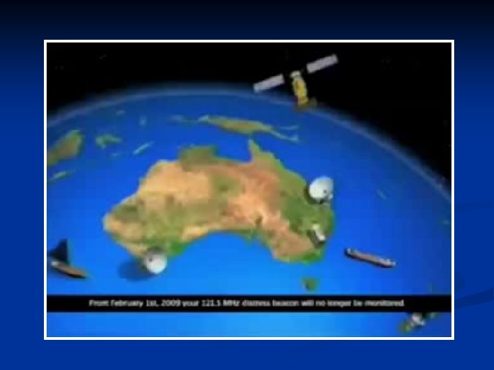
Types of EPIRB 1. 406 MHz COSPAS/SARSAT EPIRB – monitored by Polar Orbiting and Geostationary satellites. Transmits bursts of information every 50 seconds with a duration of only 0. 44 seconds. 5 watts radiated power. 2. 121. 5 MHz VHF EPIRB – monitored by aircraft. Transmits a continuous sweep-tone modulated signal. Radiated power about 100 milliwatts. Phased out on February 1, 2009. 3. Channel 70 VHF EPIRB – monitored on VHF DSC

• COSPAS = Cosmicheskaya Systyema Poiska Aariynyich Sudov Which loosely translates into: “The Space System for the Search of Vessels in Distress” • SARSAT = Search And Rescue Satellite Aided Tracking

Ratification 1978: Canada, France and the USA agree to cooperate on the development of the SARSAT lowaltitude polar orbiting system. n Russia declares its interest in co-operating with the objective of ensuring inter-operability of their COSPAS system with SARSAT. n 1980: Ratified n 1985: System Operational n

Types of Emergency Beacons EPIRB ELT Emergency Position Indicating Radio Beacon Emergency Locator Transmitter PLB Personal Locator Beacon

The COSPAS/SARSAT System n Originally planned and developed using satellites in Low Polar Orbit (LEOSAR) n 1998: New satellite system - Geostationary satellite (GEOSAR)
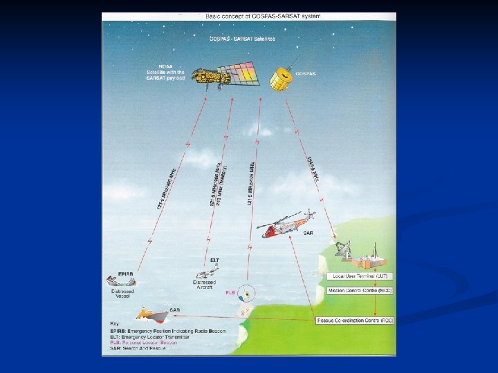
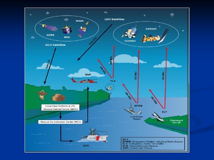
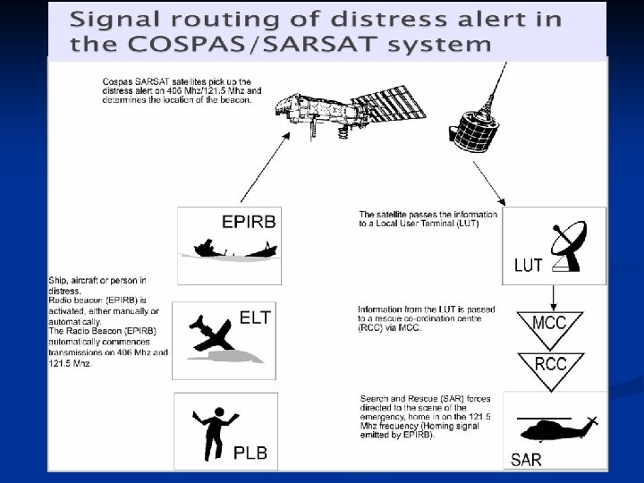
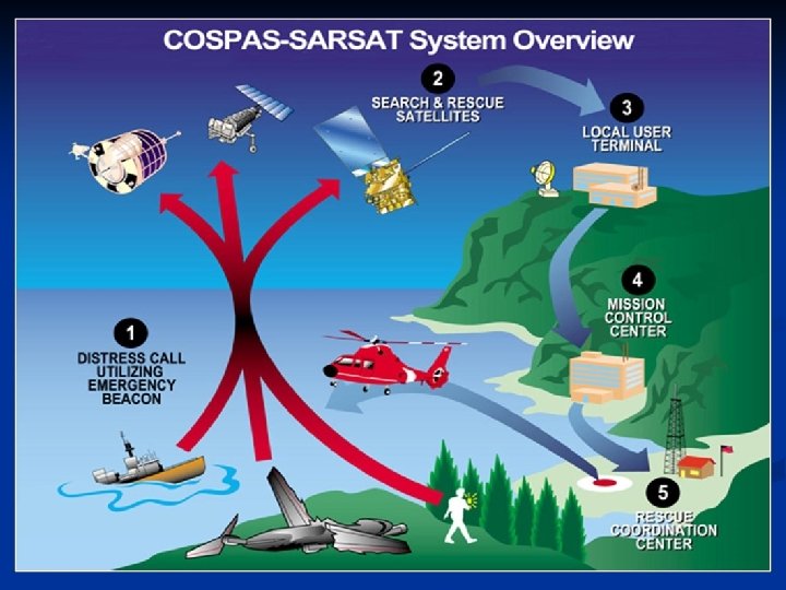

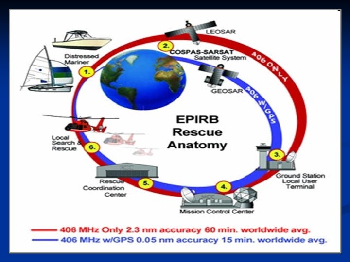
Concept of Operations The Cospas-Sarsat System provides distress alert and location information to search and rescue (SAR) services throughout the world for maritime, aviation and land users in distress. The System is comprised of: n Satellites in Low-altitude Earth Orbit (LEOSAR) and Geostationary Orbit (GEOSAR) that process and/or relay signals transmitted by distress beacons; n Ground receiving stations called Local User Terminals (LUT) which process the satellite signals to locate the beacon; and n Mission Control Centres (MCC) that provide the distress alert information to SAR authorities. n The Cospas-Sarsat System can detect and locate distress beacons that operate at 406 MHz. Satellite processing of old analogue technology beacons that transmit at 121. 5 MHz ended on 1 February 2009.
 satellite system n Low Polar orbiting satellite.")
Low Earth Orbit Search And Rescue (LEOSAR) satellite system n Low Polar orbiting satellite. Orbit time 1. 40 hours. Approximate distance 850 to 1000 km.

Performs Doppler locating function n Frequencies used are 121. 5 MHz and 406 MHz n 406 MHz beacon - Digital ID (MMSI) can be included; global coverage because it store and forward alerts for 48 hrs. n 121. 5 MHz beacon – satellites work only as repeaters and require free visibility; not global coverage. Phased out February 1, 2009. n

LEOSAR 406 MHz beacon detections can be stored on board the satellite and re-broadcast later when a ground station (LUT) comes in view Previous method: Detection of a 121. 5/243 MHz beacon required mutual visibility between beacon, satellite and the ground station (LUT)

55 LEOLUTs track the Cospas-Sarsat polar-orbiting satellites The white area shows where over-flying satellite could be seen by a LEOLUT.

 satellite system n n GEOLUTs detect transmissions from 406")
Geostationary Search And Rescue (GEOSAR) satellite system n n GEOLUTs detect transmissions from 406 MHz beacons relayed by high altitude geostationary satellites. Instantaneous alerting. Continuous coverage between 70 N and 70 S Position information must be acquired from GPS and encoded in beacon message

Area of coverage of the 406 MHz GEOSAR satellites and its 21 LUTs

Combined LEOSAR-GEOSAR operations
 Status in operation Sarsat-8 (NOAA-16) in operation Sarsat-9")
GEOSAR LEOSAR 6 Satellites Sarsat-7 (NOAA-15) Status in operation Sarsat-8 (NOAA-16) in operation Sarsat-9 (NOAA-17) in operation Sarsat-10 (NOAA-18) in operation Sarsat-11 (METOP-A) in operation Sarsat-12 (NOAA-N') in operation 5 Satellite Status GOES-11 West (135° W) in operation GOES-12 (60° W) Stand by test satellites GOES-13 East (75° W) in operation GOES-14 (105° W) Stand by test satellites GOES-15 (89. 5° W) Stand by test satellites INSAT 3 A (93. 5° E) in operation MSG-1 (9. 5° E) in operation MSG-2 (0°) in operation

Comparison of 121. 5 MHz vs 406 MHz with GPS 406 MHz 121. 5 MHz Search Time = Minimal Search Time = 2 - 3 hours Search Time = 12+ hours

Location Accuracy 121. 5 MHz = 12 NM 406 MHz = 2. 3 NM 406 MHz w/GPS = 0. 05 NM
 LEOSAR Local User Terminals (LEOLUT) • Track COSPAS")
LEOLUTS and GEOLUTS (Cospas-Sarsat Ground Stations) LEOSAR Local User Terminals (LEOLUT) • Track COSPAS and SARSAT satellites • Recover beacon signals • Perform error checking • Perform Doppler processing • Send alert to Mission Control Center • 55 LUT GEOSAR Local User Terminals (GEOLUT) • Track GOES, MSG, & INSAT satellites • Recover beacon signals • Perform error checking • Send alert to Mission Control Center • 21 LUT
")
U. S. Local User Terminals (LUTs)
 serves as the hub of information sent by")
MCC A mission control center (MCC) serves as the hub of information sent by the Cospas-Sarsat system. The main function of an MCC is to collect, store, and sort alert data from LUTs and other MCCs, and to distribute alert data to RCCs, and other MCCs.
 • 30 MCC in operation • Receive alerts from national")
Mission Control Centres (MCCs) • 30 MCC in operation • Receive alerts from national LUTs and foreign MCCs. • Validate, match and merge alerts to improve location accuracy and determine the correct destination. • Query 406 MHz Registration Database and transmit registration info with distress alert. • Transmit alerts to Rescue Coordination Centers (RCCs) and filters redundant data. • Most MCC functions are handled automatically…no manual intervention = efficiency! USMCC Suitland, Maryland

MCCs worldwide
 - Receive COSPAS-SARSAT Distress Alerts from MCCs - Coordinate the")
Rescue Coordination Centres (RCCs) - Receive COSPAS-SARSAT Distress Alerts from MCCs - Coordinate the Rescue Response
- Slides: 32