ELECTRONIC SYSTEMS OF POSITION FIXING AIDS 2 BY

ELECTRONIC SYSTEMS OF POSITION FIXING AIDS - 2 BY: SACHIN ROY 1789 A B. sc(NS)-14 GROUP-IV

TYPES OF ERROR 1. Satellite Errors: Slight inaccuracies in time keeping by the satellites can cause errors in calculating positions. Satellites drift slightly from their predicted orbits which contributes to errors. 2. Satellite Orbits Slight shifts of the orbits are possible due to gravitation forces Sun and moon have a weak influence on the orbits The resulting error being not more than 2 m 3. Multi-path error: As the GPS signal finally arrives at the earth’s surface, it may be reflected by local obstructions before it gets to the receiver’s antenna. This is called multi-path error as the signal is reaching the antenna in single line path as well as delayed path. The effect is similar to a double image on a tv set. Receiver Error: Since the receivers are also not perfect, they can introduce their own errors which usually occur from their clocks or internal noise. Despite the synchronization of the receiver clock with the satellite time during the position determination, the remaining inaccuracy of the time still leads to an error of about 2 m in the position determination
, multi-constellation")
Multi-constellation With the emergence of multiple satellite navigation systems (both regional and global), multi-constellation receivers are becoming widely available. Multi-frequency Several GNSS signals are allocated to different frequencies - for instance, the L 1 and L 2 bands. Whether in single or multi-constellation approaches, receivers can benefit from multi-frequency signal processing for removal of the frequency-dependent errors on the signals, hence improving receiver accuracy. Augmentation GNSS receivers can also benefit from corrections or measurements provided by the available augmentation systems to improve their accuracy and performance. As the name implies, such systems aim at providing augmentation information to the GNSS users, consisting of corrections and/or auxiliary measurements that increase precision and accuracy in the calculated solution.

Differential techniques enable improved receiver accuracy by providing the receiver with additional information, such as measurements from other receivers in the vicinities, or corrections computed independently.

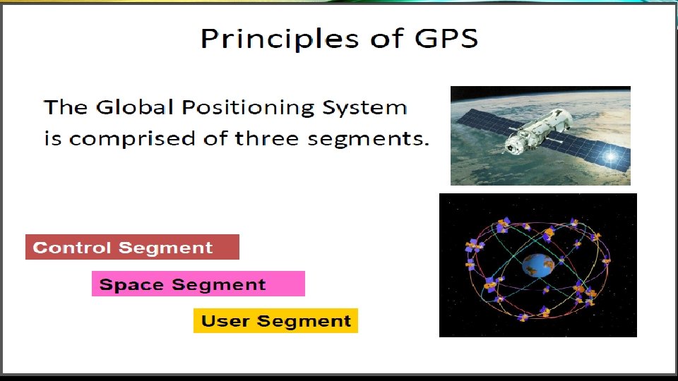
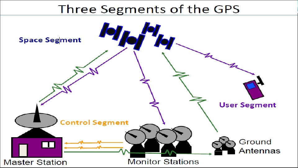
The Control Segment of GPS consists of: Master Control Station: The master control station, located at Schriever Air Force Base in Colorado Springs, Colorado, is responsible for overall management of the remote monitoring and transmission sites. Monitor Stations: Six monitor stations are located at Schriever Air Force Base in Colorado, Cape Canaveral, Florida, Hawaii, Ascension Island in the Atlantic Ocean, Diego Garcia Atoll in the Indian Ocean, and Kwajalein Island in the South Pacific Ocean. Ground Antennas: Four ground antennas monitor and track the satellites from horizon to horizon. They also transmit correction information to individual satellites.

Waypoint A waypoint is term used to refer to an intermediate point or place on a route or line of travel, a stopping point or point at which course is changed. What is a waypoint? A waypoint is a fixed location with a specified longitude and latitude and UTM coordinates, which is maintained by a global positioning system (GPS). It is any mapped reference point useful for pilotage, which navigators can identify on land or at sea to verify their location. Natural waypoints may include natural rock formations, springs and oasis. Artificial waypoints may include buoys, lighthouses and radio beacons. A waypoint can be a destination, a location of a course change along a journey, or a point of reference useful for navigation. A GPS receiver can record a waypoint at its current location to an accuracy of within 3 meters or better if using Wide Area Augmentation System (WAAS) capability. Waypoints can also be marked on a computer mapping program and uploaded to the GPS receiver, marked on the receiver's own internal map, or entered manually on the device as a pair of coordinates.

GPS inputs to other navigational aids Dedicated devices have various degrees of mobility. Hand-held, outdoor, or sport receivers have replaceable batteries that can run them for several hours, making them suitable for hiking, bicycle touring and other activities far from an electric power source. Their screens are small, and some do not show color, in part to save power. Some use transflective liquid-crystal displays, allowing use in bright sunlight. Cases are rugged and some are water resistant. Other receivers, often called mobile are intended primarily for use in a car, but have a small rechargeable internal battery that can power them for an hour or two away from the car. Special purpose devices for use in a car may be permanently installed and depend entirely on the automotive electrical system. The pre-installed embedded software of early receivers did not display maps; 21 st century ones commonly show interactive street maps (of certain regions) that may also show points of interest, route information and step-by-step routing directions, often in spoken form with a feature called "text to speech".

THANK YOU
- Slides: 12