Electrical Geophysical Prospecting Methods outlines of Lecture v


:")
 are those in which the frequency content")


 Configurations The purpose of electrical surveys is to determine the subsurface resistivity")
- Slides: 19
Electrical Geophysical Prospecting Methods
outlines of Lecture v. Introduction v. Electrical Geophysical Applications v. Classification of Electrical Geophysical Methods v Electrical Resistivity Method v. Electrical properties of rocks v. The relationship between geology and resistivity v. Electrode (arrays) Configurations
Introduction Electrical Geophysical Prospecting Methods �Detect the surface effects produced by electric current flow in the ground. �Using electrical methods, one may measure potentials, currents, and electromagnetic fields which occur naturally or are introduced artificially in the ground. �variations in electrical parameters found in different rocks and minerals.
Electrical Geophysical Applications Electrical geophysical methods have been used for many decades in: Ø hydrogeological, Ø Petroleum, Ø mining and Ø geotechnical investigations. More recently, it has been used for Ø environmental and engineering problems.
Classification of Electrical Geophysical Methods 1. According to the type of energy source , Electrical Geophysical Methods classified into natural(1 &2) or artificial (the rest). Electrical Geophysical Methods include: 1. Self-Potential (SP), 2. telluric currents and magnetotellurics (MT) 3. Resistivity, (DC resistivity) 4. Equipotential and mise-à-la-masse, (MALM) 5. Electromagnetic (EM), and 6. Induced Polarization (IP)
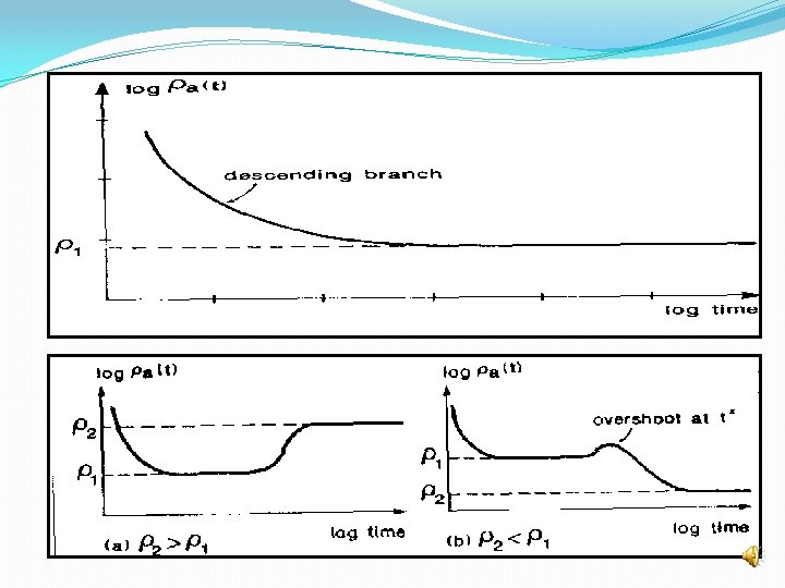
2. According to domains of measurement data A. Time Domain Methods (TDEM or TEM): are those in which the magnitude only or magnitude and shape of the received signal is measured, Techniques in this class are discussed under the headings of; DC resistivity, induced polarization, time-domain electromagnetic, and self-potential.
B. Frequency Domain Methods (FDEM or FEM) are those in which the frequency content of the received signal is measured. Generally FDEM methods are continuous source methods, and measurements are made while the source is on. The measurement is of magnitude at a given frequency. Techniques in this class are discussed under the headings of VLF, terrain conductivity, and metal detectors.
1 - Resistivity Method
Electrical properties of rocks v. Properties that affect the resistivity of a soil or rock include porosity, water content, composition (clay mineral and metal content), salinity of the pore water, and grain size distribution. v Variations in the resistivity of earth materials, either vertically or laterally, produce variations in the relations between the applied current and the potential distribution as measured on the surface.
v. The relationship between the current and potential distribution is described by Ohm’s law: V = IR V= difference of potential between two points on the wire. I = current through the wire R = resistance measured between the same two points as the difference of potential. The resistance (R) of a length of wire is given by v. The conductivity (σ) of a material is defined as the reciprocal of its resistivity (ρ).
v. In most earth materials, the conduction of electric current takes place virtually entirely in the water occupying the pore spaces or joint openings, since most soil- and rock-forming minerals are essentially nonconductive. v. Clays and a few other minerals, notably magnetite, hematite, carbon, pyrite, and other metallic sulfides, may be found in sufficient concentration to contribute measurably to the conductivity of the soil or rock.
v. Water, in a pure state, is virtually nonconductive but forms a conductive electrolyte with the presence of chemical salts in solution, and the conductivity is proportional to the salinity. v. The effect of increasing temperature is to increase the conductivity of the electrolyte. When the pore water freezes, there is an increase in resistivity.
v. Electrical resistivity surveys made on frozen ground are likely to encounter difficulties because of the high resistivity of the frozen surface layer and high contact resistance at the electrodes. v. The effect of freezing on resistivity makes the resistivity method very useful in determining the depth of the frozen layer. v. The conduction of current in soil and rock is through the electrolyte contained in the pores, resistivity is governed largely by the porosity
The relationship between geology and resistivity According to (van Blaricon 1980; Telford et al. 1976; Keller and Frischknecht 1966).
v Igneous and metamorphic rocks typically have high resistivity values. The resistivity of these rocks is greatly dependent on the degree of fracturing, and the percentage of the fractures filled with ground water. v Sedimentary rocks, which usually are more porous and have a higher water content, normally have lower resistivity values. Wet soils and fresh ground water have even lower resistivity values. Clayey soil normally has a lower resistivity value than sandy soil.
v. The resistivity method an ideal technique for mapping the saline and fresh water interface in coastal areas v. Metals, such as iron, have extremely low resistivity values. v. Chemicals which are strong electrolytes, such as potassium chloride and sodium chloride, can greatly reduce the resistivity of ground water to less than 1 ohm even at fairly low concentrations. The effect of weak electrolytes, such as acetic acid, is comparatively smaller. v. Hydrocarbons, such as xylene, typically have very high resistivity values.
Electrode (arrays) Configurations The purpose of electrical surveys is to determine the subsurface resistivity distribution by making measurements on the ground surface. The resistivity measurements are normally made by injecting current into the ground through two current electrodes (C 1 and C 2 , and the resulting voltage difference at two potential electrodes (P 1 and P 2).