El Nino Southern Oscillation ENSO Brad Pugh Climate
 Brad Pugh Climate Prediction Center National Oceanic and Atmospheric")
El Nino Southern Oscillation (ENSO) Brad Pugh Climate Prediction Center National Oceanic and Atmospheric Administration Acknowledgement: CPC ENSO Monitoring Team

What is ENSO?

ENSO Defintion • El Nino Southern Oscillation – Global coupled oceanatmosphere phenomenon that occurs in the tropical Pacific • El Nino: The Little Boy, or Christ Child in Spanish, name given by fishermen off the coast of South America in the 1600 s, with the appearance of episodic very warm water in the Pacific Ocean around December • Ocean signature: El Nino, La Nina – Major temperature fluctuations in surface waters

The ENSO Cycle • Naturally occurring phenomenon • Equatorial Pacific fluctuates between warmer-than-average (El Niño ) and colder-than-average (La Niña) conditions • The changes in sea surface temperatures (SSTs) affect the distribution of tropical rainfall and atmospheric circulation features • Changes in intensity and position of jet streams and storm activity occur at higher latitudes • ENSO is associated with global impacts as a result of these adjustments in the tropical and extratropical circulation

Sea Surface Temperatures: El Niño vs. La Niña Equatorial cold tongue is weaker than average or absent during El Niño, resulting in positive SST anomalies Equatorial cold tongue is stronger than average during La Niña, resulting in negative SST anomalies
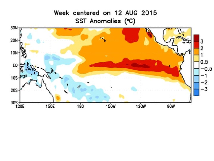

3 -month historical SST anomalies Note: El Nino to La Nina transition common JAS
 Issued: 2 November 2015 The")
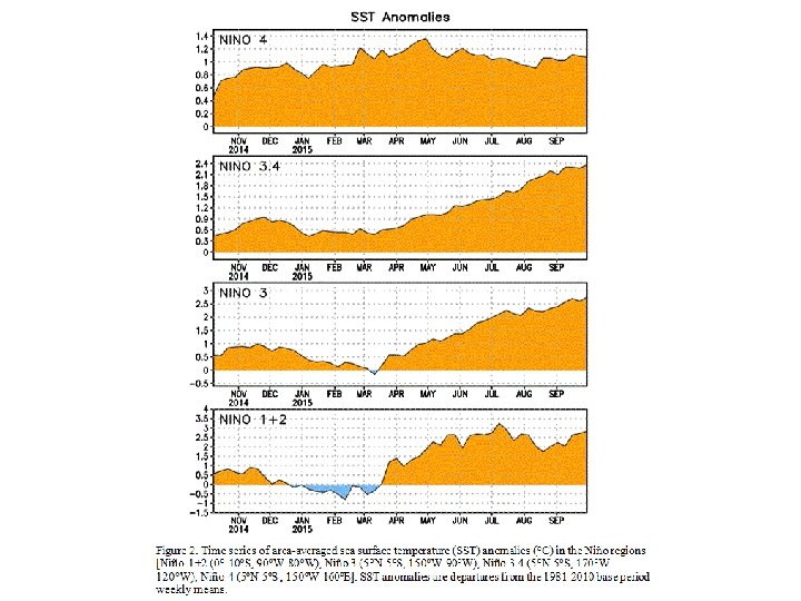
SST Outlook: NCEP CFS. v 2 Forecast (PDF corrected) Issued: 2 November 2015 The CFS. v 2 ensemble mean (black dashed line) predicts El Niño through AMJ 2016.

Precipitation: El Niño vs. La Niña El Nińo La Nińa Enhanced rainfall occurs over warmerthan-average waters during El Niño. Reduced rainfall occurs over colderthan-average waters during La Niña.
 across Maritime")
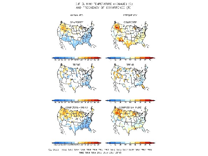
DRY WET Strong atmospheric response across the global tropics 1. Dry (wet) across Maritime Continent (equatorial central-east Pacific) 2. Active Central and East Pacific Hurricane Season 3. Effects across mid-latitudes more apparent during cold season

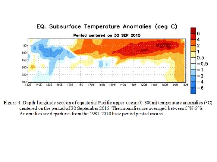
Normal El Nińo Trade winds become disrupted with convection shifts eastward over the central and/or eastern Pacific Ocean. Convection becomes suppressed over the far western Pacific/ Indonesia. La Nińa Convection becomes stronger over the far western Pacific Ocean/ Indonesia and more suppressed in the central Pacific.

Typical Evolution of the ENSO Cycle • Irregular cycle with alternating periods of warm (El Niño) and cold (La Niña) conditions • Events tend to occur every 2 -7 years • Strongest El Niño episodes appear to occur, on average, every 10 -15 years • Generally episodes form during the spring or summer, peak during the winter, and decay the following spring. • La Niña episodes can last multiple years (1 -3 years). Less common for El Niño, which last up to ~18 months. • Transitions from El Niño to La Niña tend to be more rapid (potential for this next cold season)

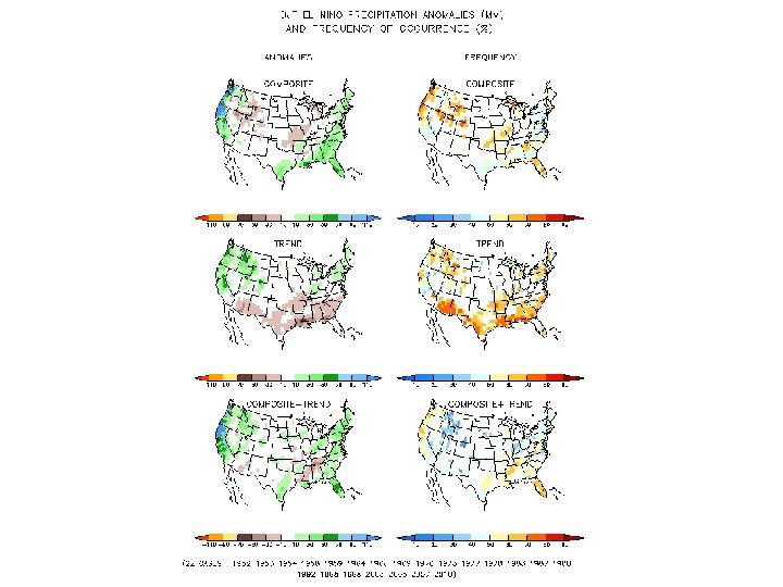
El Nino Teleconnections Dec-Feb Gridded precipitation anomalies (CPC Unified Precipitation associated with the standardized Nino 3. 4 index From 1948 – 2010. Nino 3. 4 region: equatorial Pacific 5 N-5 S; 120 W – 165 W Note: La Nina precip patterns are generally opposite
 and")
Summary • Naturally occurring • Equatorial Pacific fluctuates between warmer-than-average (El Niño ) and colder-than-average (La Niña) conditions • The changes in sea surface temperatures (SSTs) affect the distribution of tropical rainfall and atmospheric circulation features • ENSO is associated with global impacts as a result of these adjustments in the tropical and extratropical circulation • CPC releases weekly and monthly updates on ENSO • https: //www. youtube. com/watch? v=mk. SRUf 02 gu 8

Thank you brad. pugh@noaa. gov
- Slides: 19