Egypt Key Terms Nile River Is the longest


- Slides: 11
Egypt
Key Terms • Nile River- Is the longest river in the world, it begins in central Africa and runs north through Egypt to the Mediterranean Sea a distance of over, 4, 000 miles. • Upper Egypt-The southern Region of Egypt • Lower Egypt- The northern Region of Egypt • Cataracts-Rapids along a river, made it difficult to sail on the Nile from Upper Egypt to Lower Egypt. • Delta- a triangle shaped area of and made from soil deposited by a river • Pharaoh-The title used by the rulers of ancient Egypt • Dynasty- Series of rulers from the same family.
Learning Targets • I can describe the relationship between the Nile and the growth of Egypt. • I can describe the reasons for the unification of Egypt. • I can explain the religious beliefs of the Egyptian people, and the importance of the afterlife. • I can locate key physical features of Africa on a map.
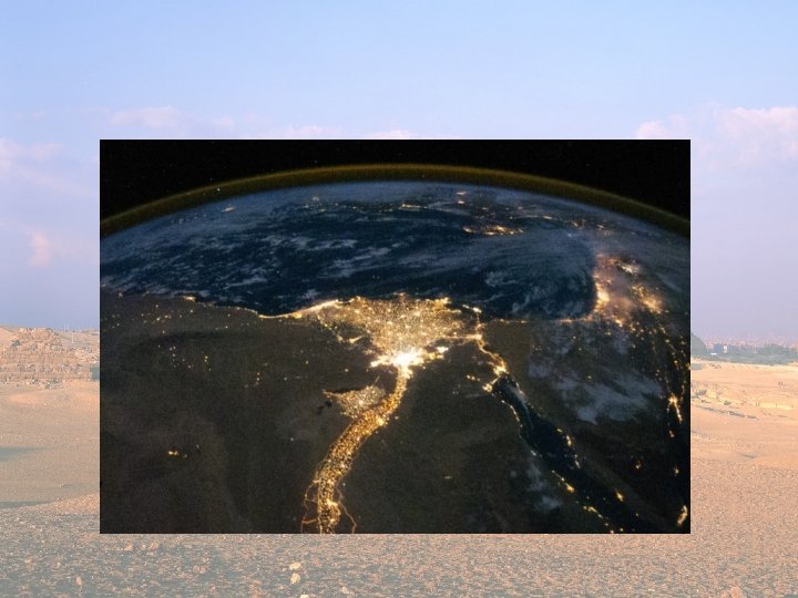
The Nile From Space
Geography of Egypt: The Nile River • Egypt is “The gift of the Nile” • Like the Tigris and Euphrates brought life to Mesopotamia, the Nile brought life to Egypt and enabled it to thrive. • The Nile is the longest river in the world. • It begins in central Africa and runs north through Egypt to the Mediterranean Sea, a distance of over 4, 000 miles.
The Nile • The Nile sliced through the desert of Upper Egypt, and created a fertile river valley about 13 miles wide • Cataracts- Rapids along a river, made it difficult to sail on the Nile from Upper Egypt to Lower Egypt. • In lower Egypt the Nile divided into several branches that fanned out and flowed into the Mediterranean Sea. • These branches formed a Delta • Delta- a triangle shaped area of and made from soil deposited by a river • Two-Thirds of Egypt’s fertile farmland was located on the Delta.
Geography of Egypt: Regions Ancient Egypt included two regions, A southern region and a northern region. The southern region was called Upper Egypt The northern region was called Lower Egypt The two were named based on their location relative to the flow of the Nile. (Flows from south to north)
Lower Egypt Upper Egypt
Flooding of the Nile • There is little rain fall in Egypt because it is a desert climate. • However each year rain falls farther south of Egypt in the highlands of East Africa. • This rainfall causes the Nile to flood. • The Nile floods Upper-Egypt in mid-summer, and Lower Egypt in the fall. • Without these floods the people of Egypt could have never farmed Egypt, this is why Egypt is “The gift of the Nile”
Tomorrow -Go into more detail about the Two Kingdoms. -The Unification of the two kingdoms. -New Vocabulary -The Old Kingdom