Ecoregions of Texas What Is An Ecoregion Ecoregion


 ¡Region 7: Edwards Plateau ¡Region 8: Llano Uplift ¡Region")


- Slides: 17
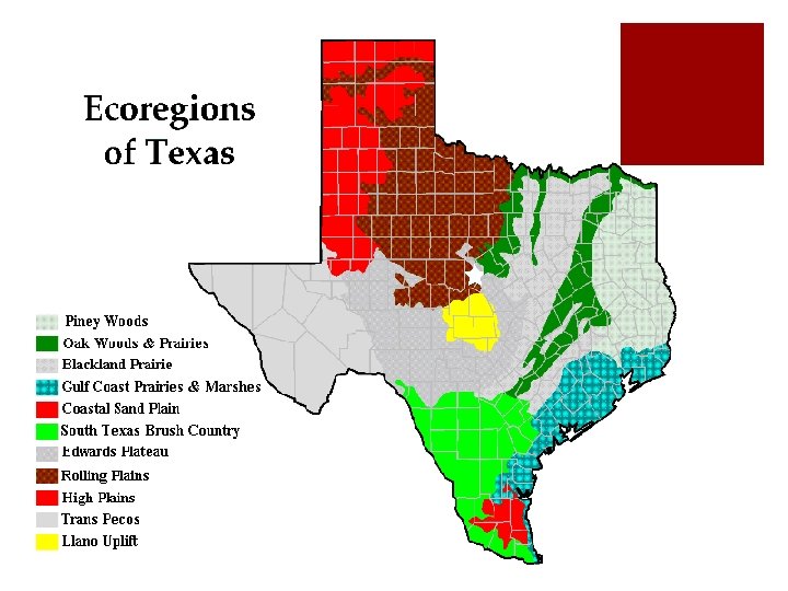
Ecoregions of Texas
What Is An Ecoregion? ¡Ecoregion – a major ecosystem with distinctive geography, characteristic plants and animals, and ecosystems that receives uniform solar radiation and moisture ¡Sometimes called an ecological region or bioregion ¡Smaller than a biome
Where Are They? ¡Region 1: Pineywoods ¡Region 2: Cross Timbers or Oak Woods and Prairies ¡Region 3: Blackland Prairies ¡Region 4: Gulf Coast Prairies and Marshes ¡Region 5: Coastal Sand Plains ¡Region 6: South Texas Brush Country
Where Are They? (cont. ) ¡Region 7: Edwards Plateau ¡Region 8: Llano Uplift ¡Region 9: Rolling Plains ¡Region 10: High Plains ¡Region 11: Trans Pecos ¡Region 12: Marine Environment
Region 1 Piney Woods ¡Climate: The average annual rainfall is 36 to 50 inches; the humidity and temperatures are typically high. ¡Soil: Largely acidic and typically pale to dark gray sands or sandy loams ¡Elevation: Ranges from 200 to 500 feet above sea level ¡Geography: Rolling terrain ¡Vegetation: Pine and oak; tall hardwood forests; areas of cropland, planted pastures, native pastures, and rich bottomlands
Region 2 Cross Timbers or Oak Woods & Prairies ¡Climate: Average annual rainfall 28 to 40 inches per year. ¡Soil: Upland soils tend to be light colored, acidic sandy loam or sands. Bottomland soils tend to be light brown to dark gray and acidic ranging from sandy loams to clays. ¡Elevation: Ranges from 300 to 800 feet above sea level ¡Geography: Gently rolling to hilly terrain ¡Vegetation: Oak savannah; patches of oak woodland alternate with grassland
Region 3 Blackland Prairies ¡Climate: The average annual rainfall is from 28 to 40 inches. The northern end of the region has its peak rainfall during the month of May. Rainfall is fairly uniform over the south-central region throughout the year. ¡Soil: Uniformly dark-colored alkaline clays interspersed with some gray acidic sandy loams ¡Elevation: Ranges from 300 to 800 feet above sea level ¡Geography: Gently rolling to nearly level terrain ¡Vegetation: Food and forage crops
Region 4 Gulf Coast Prairies and Marshes ¡Climate: Rainfall annually ranges from 30 to 50 inches per year; high humidity and warm temperatures ¡Soil: Acidic sands and sandy loams. Clays are present in the river bottoms. ¡Elevation: Nearly level, less than 150 feet above sea level, cut by streams and rivers flowing into the Gulf of Mexico ¡Geography: Coastal barrier islands, marshes near the bays and estuaries, prairies ¡Vegetation: Salt grass, tallgrass prairies, live oak woodlands, mesquite and acacias, oaks dispersed along the coast, tall woodlands in the river bottoms
Region 5 Coastal Sand Plains ¡Climate: Rainfall averages 24 to 28 inches per year ¡Soil: Mostly sands ¡Elevation: Elevations are mainly level; less than 150 feet above sea level ¡Geography: Windblown sands and unstable dunes with grasslands, stands of oak, and salt marshes ¡Vegetation: Tallgrass prairie and live oak woodlands, mesquite savannah, and salt marshes
Region 6 South Texas Brush Country ¡Climate: Average annual rainfall of 16 to 35 inches increases from the West to East. High temperatures with very high evaporation rates are typical of summer. ¡Soil: Alkaline to somewhat acidic clays, clay loams and shallow caliche soils ¡Elevation: Ranges from sea level to 1000 feet ¡Geography: Flat plains to gently rolling terrain ¡Vegetation: Thorny shrubs, trees, and cactus dispersed with patches of palms and subtropical woodlands
Region 7 Edwards Plateau ¡Climate: Rainfall averages vary from 15 to 34 inches ¡Soil: Underlying limestone; mostly shallow with an assortment of surface textures ¡Elevation: Ranges from somewhat less than 100 feet to over 3, 000 feet above sea level ¡Geography: Several springs, stony hills, and steep canyons and caves; many river systems separate the surface which creates a rough but well-drained landscape ¡Vegetation: Grasslands, juniper/oak woodlands, and plateau live oak or mesquite savannah
Region 8 Llano Uplift ¡Climate: Rainfall averages from 24 to 32 inches per year ¡Soil: Coarse textured sands, produced from weathered granite over thousands of years ¡Elevation: Ranges from 825 to 2, 250 feet above sea level ¡Geography: Hilly to rolling landscape. With some of the oldest rocks in Texas, the region contains unique minerals, rock formations, and large granite domes. ¡Vegetation: Oak-hickory or oak-juniper woodlands, mesquite-mixed brush savannah, and grasslands
Region 9 Rolling Plains ¡Climate: Rainfall averages 20 to 28 inches, dry summers with high temperatures and high evaporation rates ¡Soil: Varies from coarse sands alongside outwash terraces by streams to clays and shales ¡Elevation: Ranges from 800 to 3, 000 feet above sea level ¡Geography: Gently rolling hills and broad flats are cut by several rivers and their tributaries. ¡Vegetation: Mesquite and shortgrass savannah, various hardwood species along streams, juniper on steep slopes along rivers
Region 10 High Plains ¡Climate: Multiple extended droughts have occurred several times over the last 100 years. ¡Soil: The texture of surface soils varies from clays in the North to sands in the South; caliche can be found beneath surface soils at depths that range from two to five feet. ¡Elevation: Ranges from 3, 000 to 4, 500 feet above sea level ¡Geography: Relatively level high plateau ¡Vegetation: Irrigated cropland. Mesquite and juniper are native vegetation.
Region 11 Trans Pecos ¡Climate: 9– 15 inches of rain; semi-arid, warm, dry winters ¡Soil: Generally shallow, saline, and unproductive ¡Elevation: 2, 000 feet to mountain ranges. The highest peak is 8, 751 feet above sea level. ¡Geography: Salt basins, sand hills, rugged plateaus, mountain slopes ¡Vegetation: Desert grassland, desert scrub, coniferous and mixed hardwood forests at mountain peaks
My Ecoregion ¡Which region do you live in? ¡Have you ever visited another region?