Ecological Nowcasting in Chesapeake Bay Christopher Brown NOAA

Ecological Nowcasting in Chesapeake Bay Christopher Brown NOAA Satellite Climate Studies Branch CICS - ESSIC University of Maryland, College Park

Importance of Coastal Ocean Monitoring & Prediction • National Goal – Congress initiated efforts to establish a coastal monitoring system and develop coastal hydrodynamic models • NOAA Goal – VADM Lautenbacher stated that an ecosystem assessment and prediction capability was a critical NOAA to provide information on coastal and marine ecosystems – He also wrote that by 2011 NOAA “should be able to forecast routinely the extent and impact of critical ecosystem events, such as harmful algal blooms” • Biological Oceanography Goal – Develop the understanding and the means to detect and predict distribution pattern of organisms

Motivation for Study • Detect and predict distribution pattern of organisms that affect society, both beneficial and harmful • Few existing methods work well and in near-real time Bloom of the coccolithophorid Emiliania huxleyi in the Barents Sea in July 2003 in Sea. Wi. FS imagery. Image courtesy of NASA Sea. Wi. FS Project and Orb. Image.

Approaches for Predicting Organisms • Process-Oriented or Mechanistic Modeling • Empirical or Statistical Modeling

Mechanistic Modeling

Statistical Modeling • Develop multi-variate empirical habitat models – Quantitatively define the preferred environmental conditions of the organism • Based on Concept of Ecological Niche – Identify the geographic locations where ambient conditions coincide with the preferred habitat of target organism

Hybrid Statistical – Mechanistic Approach • Develop multivariate empirical habitat models • Drive habitat models using realtime data acquired from a variety of sources Habitat Model

Hybrid Statistical – Mechanistic Ecological Approach • Old technique employed in new way – GAP Analysis: retrospective analysis – Ecological Nowcasting: near-real time

Ecological Nowcasting In Chesapeake Bay Currently generate nowcasts of two species in Chesapeake Bay • Sea Nettles, Chrysaora quinquecirrha • Dinoflagellate Karlodinium micrum Chance of encountering sea nettle, C. quinquecirrha, on August 15, 2004 Relative abundance of the harmful algal bloom K. micrum on May 27, 2004

Nowcasting Sea Nettle Distributions in Chesapeake Bay: An Overview C. W. Brown 1, R. R. Hood 2, T. Gross 3, Z. Li 3, M. -B. Decker 2, J. Purcell 2 and H. Wang 4 1 NOAA/NESDIS Office of Research & Applications 2 Horn Point Laboratory, UMCES 3 NOAA/NOS Coast Survey Development Laboratory 4 VIMS, College of William and Mary Funded by NORS Grant, Maryland Sea. Grant, NCCOS Eco. Fore 04 Chrysaora quinquecirrha (Photo by Rob Condon)

Introduction: Sea Nettles • Chrysaora ephyra and medusa seasonally populate Chesapeake Bay ephyra • Chrysaora is biologically important and impacts recreational activities juvenile medusa (adult) egg strobila • Knowing the distribution of Chrysaora would provide valuable information scyphistoma polyp larva Life Cycle of Chrysaora From: T. L. Bryant and J. R. Pennock (eds). 1988. The Delaware Estuary: Rediscovering a Forgotten Resource. University of Delaware Sea Grant College Program. Newark, DE.

Sea Nettle Nowcasting Procedure 1. Estimate current surface salinity and temperature fields SST Likelihood of Chrysaora 2. Georeference salinity and SST fields 3. Apply habitat model 4. Generate image illustrating the likelihood of encounter of Chrysaora Habitat Model Salinity

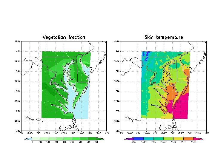
Surface Salinity 35 • Generated using hydrodynamic model developed for the Chesapeake Bay 30 25 • Model forced using near-real time input 20 15 • Model attributes: – Horizontal Resolution: 1 -5 kilometers – Vertical Resolution: 1. 52 meters – Error: 2 - 3 ppt 10 5 Model generated surface salinity in Chesapeake Bay for April 20, 2005 0

Sea-Surface Temperature 35 Two Sources: – Error: 2 - 3 °C 2. Derived from NOAA AVHRR satellite imagery – Resolution: 1 km – Weekly composite – Bias: 0. 5 °C; STD: 1. 0°C 25 20 15 10 5 0 Model generated sea-surface temperature in Chesapeake Bay for April 20, 2005 Sea-surface Temperature (ºC) 1. Generated by hydrodynamic model 30

Sea Nettle Habitat Model • Models developed to predict: 1. Probability of encountering Chrysaora 2. Density of Chrysaora • Analyzed relationship between Chrysaora, salinity and sea-surface temperature • Samples collected in surface waters (0 – 10 m) of Chesapeake Bay (n = 1064) – 2/3 model training – 1/3 model testing
 and salinity (10")
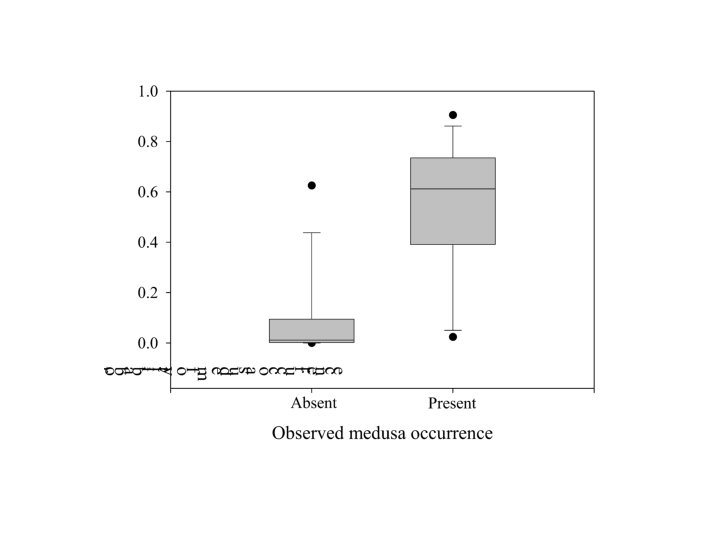
Sea Nettle Habitat Nettle medusa occupy narrow temperature (26 -31 °C) and salinity (10 -16 PSU) range. Salinity optimum = 13. 5 PSU.

Probability of Encountering Sea Nettles • Combination of salinity and SST is a good predictor of Chrysaora presence • If SST < 34°C: – p = elogit / (elogit + 1), where, logit = -8. 120 + (0. 351*SST) - (0. 572* |SAL - 13. 5|) – Hosmer-Lemeshow Goodness of Fit P = 0. 493

Nowcasting the Relative Abundance of Karlodinium micrum in Chesapeake Bay Christopher W. Brown 1, Douglas L. Ramers 2, Thomas F. Gross 3, Raleigh R. Hood 4, Peter J. Tango 5 and Bruce D. Michael 5 1 NOAA, 2 University Of Evansville, 3 NOAA & Chesapeake Research Consortium, 4 University of Maryland Center for Environmental Science – Horn Point Laboratory, 5 Maryland Department of Natural Resources Project Funded by NOS MERHAB Program

Karlodinium micrum § A common estuarine dinoflagellate found along the U. S. East Coast § Seasonally abundant in Chesapeake Bay § Contributed to several fish kills in Chesapeake Bay § Significant blooms confined to a relatively narrow range of salinity and temperature Photomicrograph of the dinoflagellate Karlodinium micrum.

K. micrum Nowcasting Procedure 1. Estimate current surface salinity and temperature fields SST Relative Abundance of K. micrum 2. Georeference salinity and SST fields 3. Apply habitat model 4. Generate image illustrating the relative abundance of K. micrum Habitat Model Salinity
 employs sea surface temperature, salinity and month to")
Habitat Model o Neural Network (NN) employs sea surface temperature, salinity and month to predict the relative abundance of K. micrum at low, medium and high or “bloom” concentrations o NN trained with samples (n = 151) of in-situ K. micrum abundance and various environmental variables o A test data set (n = 81) was extracted from the available data to assess the model’s performance

Schematic Representation of Neural Network Input Layer X 1 I N P U T S X 2 X X 3 h h h Xn wij Hidden Layer Output Layer PE 1 f (W h X + b) a. PE PE 2 f (W h X + b) h h h PEm f (W h X + b) Xi * wij a. PE PE out f (W h X + b) Classify a= 1 0 -1 = foutput(Woutputhfhidden (Whidden h X + bhidden) + boutput)

Issues and Advantages of Neural Networks • Issues – “Black Box” • Advantages & Uses – Useful for representing and processing inexact and sparse data and for performing approximate reasoning over uncertain knowledge and ill-defined problems – Useful in discerning patterns and relationships – No a-priori distribution assumed

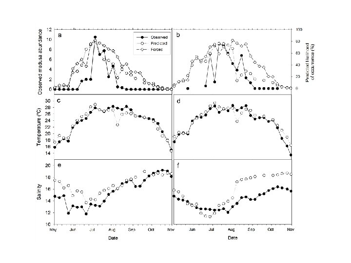
K. micrum Neural Network Performance

Nowcast vs. In-Situ Comparison May 27, 2004 - Nowcast 0 -10 cells/ml 10 -2000 cells/ml >2000 cells/ml May 23 -26, 2004 - In-situ

Nowcast WWW Sites Sea Nettle and K. micrum nowcasts are generated daily and are available on the World Wide Web. http: //coastwatch. noaa. gov/seanettles http: //coastwatch. noaa. gov/cbay_hab/index. html

Future Directions and Work o Continue nowcast validation and refine habitat models of Chrysaora and Karlodinium o Develop habitat models for additional HAB species in Chesapeake Bay o Incorporate additional environmental variables into habitat models and nowcast system to enhance HAB prediction capability o Generate historical distribution patterns of occurrence and relative abundance from retrospective salinity and temperature to document interannual variability

Issues With Empirical Approach • Empirical models are specific for each location and population • Development of empirical models require sufficient number of samples • Species acclimate to environment, i. e. habitat model may change

Regional Ecosystem Modeling • Objective: Develop a fully integrated, bio-physical model of Chesapeake Bay and its watershed that assimilates in-situ and satellite -derived data. • Purpose: – Near-Real Time Applications: Nowcasting and forecasting of marine organisms, ocean health, and coastal conditions – Climate Research: Estimating effect of climate change on the health of coastal marine ecosystems • Partners: NOAA, CICS-ESSIC, other UMD departments, Meteorology, and programs, e. g. UMCES. Sea. Wi. FS True-Color Image of Mid-Atlantic Region from April 12, 1998. Image provided by the Sea. Wi. FS Project, NASA/Goddard Space Flight Center and ORBIMAGE

Regional Ecosystem Model Plans & Objectives • Develop transportable modeling system that can be modified for other regions – Chesapeake Bay used as “test bed” site due to extensive in-situ data for verification • Employ satellite imagery in system for monitoring, model forcing and data assimilation to permit use in locations where in-situ assets are limited

Advanced Study Institute for Environmental Prediction • Institute dedicated to research on environmental prediction and monitoring – Perform research and provide core support to determine what present and future observations need to be sustained beyond numerical weather prediction in support of Earth system predictive models, crops models, and predictive disease models • Staffed by personnel from NOAA, NASA Goddard, and the University of Maryland • $1. 5 M budgeted for Institute in FY 06 2006 Science, State, Justice and Commerce Appropriations conference report

Thank You!

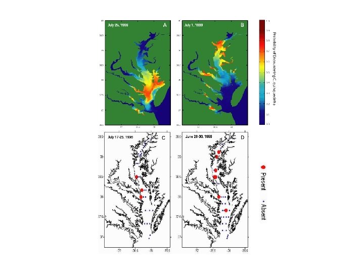
Interannual Variability Probability of Encountering C. quinquecirrha July 25, 1996 July 29, 1999 Likelihood of Encountering C. quinquecirrha in July 1996 and 1999

Vibrio cholerae • Presence predicted as function of water temperature and salinity (Louis et al. , 2003) • Association with plankton Electron photomicrograph of Vibrio cholerae: curved rods with polar flagellum. http: //microvet. arizona. edu/Courses/MIC 420/lecture_notes/vibrio/em. html
- Slides: 40