EC 409 Satellite Communication www ec 409 weebly

EC 409 - Satellite Communication www. ec 409. weebly. com By SADHISH PRABHU

Unit 1 • • • Introduction Frequency Allocations for Satellite Services Intelsat – U. S. Domsats – Polar Orbiting Satellites Kepler’s First Law – Kepler’s Second Law – Kepler’s Third. Law Definitions of Terms for Earth-orbiting Satellites Orbital Elements – Apogee and. Perigee Heights Orbital Perturbations – Effects of a Nonspherical Earth – Atmospheric Drag –Inclined Orbits Calendars – Universal Time – Julian Dates – Sidereal Time The Orbital Plane– The Geocentric-Equatorial Coordinate System Earth Station Referred to the IJK Frame – The. Top centric-Horizon Co-ordinate System The Sub-satellite Point – Predicting Satellite Position. Problems

Introduction : History of Satellites • Communicating through a satellite first appeared in the short story titled “The Brick Moon, ” written by Edward Everett Hale and published in The Atlantic Monthly in 1869– 70. • The first practical concept of satellite communication was proposed by Royal Air Force officer Arthur C. Clarke in a paper titled “Extra-Terrestrial Relays: Can Rocket Stations Give World-wide Radio Coverage? ” published in the October 1945 issue of Wireless World. • In October 1957 communications started picking up a regular beeping noise coming from space. • The signals were coming from Russia's Sputnik 1, the world's first manmade satellite. • It was January 1958, before a Jupiter rocket successfully launched Explorer 1, the first American satellite.

Introduction : History of Satellites • In July 1963 the Hughes Aircraft Corporation launched the experimental Syncom 2 for NASA, the world's first geosynchronous communications satellite • It carried the first live two-way satellite call between heads of state when President John F. Kennedy in Washington, D. C. , telephoned Nigerian Prime Minister Abubaker Balewa in Africa. • The third Syncom satellite transmitted live television coverage of the 1964 Olympic Games from Tokyo.

Introduction : History of Satellites • The world's first commercial communications satellite was Early Bird, built for the Communications Satellite Corporation (COMSAT) by Hughes. • It was launched on April 6, 1965, and placed in commercial service after moving into geosynchronous orbit 36, 000 Km above the equator. • That meant it was always on station to provide line of sight communications between Europe and North America. • Early Bird didn't have a battery - and worked only when its solar panels were exposed to the sun.

Introduction : History of Satellites • The launch of the Intelsat 3 satellites in 1969 created a global TV and speech communications network that spanned the Atlantic, Pacific and Indian Oceans. • The introduction of multiple-beam antennas in the 1980 s brought new improvements in efficiency, as a satellite's power could now be concentrated on small regions of the Earth, making possible smalleraperture (coverage area), lower-cost ground stations. • The Capacity (the number of simultaneous television and speech channels carried) grew as well.

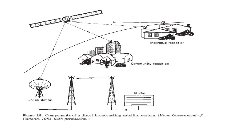
Introduction : How Satellites Work 1. A Earth Station sends message in GHz range. (Uplink) 2. Satellite Receive and retransmit signals back. (Downlink) 3. Other Earth Stations receive message in useful strength area. (Footprint)

Advantages of Satellite communication • Satellite links are unaffected by the propagation variations that interfere with HF radio. • Free from the high attenuation of wire or cable facilities • Capable of spanning long distances. • The numerous repeater stations required for line-of-sight or troposcatter links are no longer needed. • They furnish the reliability and flexibility of service that is needed to support a military operation.

Advantages of Satellite communication • The system is capable of handling thousands of communications channels. • Frequencies are not dependent upon reflection or refraction and are affected only slightly by atmospheric phenomena. • Destruction of a single communication satellite would be quite difficult and expensive. • A high degree of freedom from jamming

Disadvantage of satellite communication • With the Satellite in position the communication path between the terrestrial transmitter and receiver is approximately 75000 km long. • There is a delay of 0. 25 sec between the transmission and reception of a signal because the velocity of electromagnetic wave is 3* 10^5 Km/second. • The time delay reduces the efficiency of satellite in data transmission and long file transfer, which carried out over the satellites. • Over-crowding of available bandwidth due to low antenna gains is occurred. • High atmosphere losses above 30 GHz limit the carrier frequency.

Services provided by satellites Name of the satellite Services Fixed satellite service • Telephone Networks • Transmitting TV signals to cable companies Broadcasting satellite service Mobile satellite services Direct Broad cast service or DTH • Land Mobile • Maritime mobile • Aeronautical Mobile Navigational satellite services GPS Meteorological satellite services Search and rescue services

Frequency Band Designations used for mobile and navigational services and for data transfer from weather satellites. used for mobile satellite services and navigation systems. used for FSS and no direct broadcast services are allowed (6/4 GHz) used at present for DBS, and it is also used for certain fixed satellite services. (14/12 GHz)

Frequency Allocations for Satellite Services • International Telecommunication Union Region 1: Europe, Africa, what was formerly the Soviet Union, and Mongolia Region 3: Asia, Australia, and the southwest Pacific Region 2: North and South America and Greenland
 Altitude (375 -1000 miles) 0. 8 GHz – 30 GHz")
Orbits : Low-Earth-Orbit (LEO) Altitude (375 -1000 miles) 0. 8 GHz – 30 GHz range Revolution time: 90 min - 3 hours. Advantages: • Reduces transmission delay • Small, low-cost • Eliminates need for bulky receiving equipment. • Handles Broad band data • Disadvantages: • Smaller coverage area. • Shorter life span (5 -8 yrs. ) than GEOs (10 yrs). • • • Subdivisions: Little, Big, and Mega (Super) LEOs. • Application : Vehicle tracking, environmental monitoring and two-way data communication. Used for short, narrowband communications
 • MEOs orbits between the altitudes of 5, 600 and 9, 500")
Middle-Earth-Orbiting (MEO) • MEOs orbits between the altitudes of 5, 600 and 9, 500 miles. • These orbits are primarily reserved for communications satellites that cover the North and South Pole.
 • Orbit is synchronous with the earths rotation. • From the ground")
Geosynchronous-Earth-Orbit (GEO) • Orbit is synchronous with the earths rotation. • From the ground the satellite appears fixed. • Altitude is about 36000 km. • Coverage to 40% of planet per satellite.

Polar Orbiting Satellites • Orbit the earth to cover the north and south polar regions.

The polar orbiters • Able to track weather conditions and provide a wide range of data, • Includes visible and infrared radiometer data for imaging purposes • radiation measurements, and • temperature profiles. • They carry ultraviolet sensors that measure ozone levels, • They monitor the ozone hole over Antarctica.

Kepler’s three Law 1. The orbit of a planet is an ellipse with the Sun at one of the two foci. 2. A line segment joining a planet and the Sun sweeps out equal areas during equal intervals of time. 3. The square of the orbital period of a planet is proportional to the cube of the semi-major axis of its orbit.

Kepler’s First Law • States that the path followed by a satellite around the primary will be an ellipse.

Eccentricity • The eccentricity is defined as • For a circle, e = 0 – The range of values of the eccentricity for ellipses is 0 < e < 1 – The higher the value of e, the longer and thinner the ellipse

Kepler’s second law • States that, for equal time intervals, a satellite will sweep out equal areas in its orbital plane, focused at the barycenter.

Kepler’s Third Law •

Example • Average orbital radius • Earth = 1. 5 X 10⁸ m • Jupiter = 7. 8 X 10⁸ m • Orbital period • Earth = 1. 0 years • Jupiter = ? ? • Ans = 11. 9 Years Find out for other planets also…

Keplers 3 rd Law Brief • Kepler’s third law can be written in the form • where • n is the mean motion of the satellite in radians per second and • μ is the earth’s geocentric gravitational constant. • With a in meters, its value is • With n in radians per second, the orbital period in seconds is given by,

Definitions of Terms for Earth-Orbiting Satellites

Inclination The angle between the orbital plane and the earth’s equatorial plane. It is measured at the ascending node from the equator to the orbit, going from east to north. Apogee The point farthest from earth. Perigee The point of closest approach to earth. Line of apsides : The line joining the perigee and apogee through the center of the earth.

Descending node The point where the orbit crosses the equatorial plane going from north to south. Ascending node The point where the orbit crosses the equatorial plane going from south to north. Line of nodes The line joining the ascending and descending nodes through the center of the earth.

• Prograde orbit: An orbit in which the satellite moves in the same direction as the earth’s rotation. • It is also known as a direct orbit. • The inclination of the orbit always lies between 0 and 90°. • Most satellites are launched in this orbit. • Because the earth’s rotational velocity provides part of the orbital velocity with a consequent saving in launch energy.

Retrograde orbit An orbit in which the satellite moves in a direction counter to the earth’s rotation, The inclination of a retrograde orbit always lies between 90 and 180°.

Argument of perigee The angle from ascending node to perigee, measured in the orbital plane at the earth’s center, in the direction of satellite motion.

Right ascension of the ascending node : For an absolute measurement of an orbit , a fixed reference in space is required. The reference chosen is the first point of Aries, otherwise known as the vernal, or spring, equinox. It occurs when the sun crosses the equator going from south to north, An imaginary line is drawn from this equatorial crossing through the center of the sun points to the first point of Aries (symbol ). This is the line of Aries. The right ascension of the ascending node is then the angle measured eastward, in the equatorial plane, from the line to the ascending node.

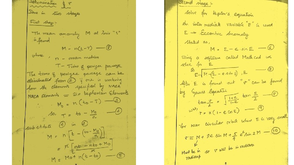
True anomaly • The true anomaly is the angle from perigee to the satellite position, measured at the earth’s center. (μ) • This gives the true angular position of the satellite in the orbit as a function of time.

Mean Anomaly • Mean anomaly “M” gives an average value of the angular position of the satellite with reference to the perigee. • For a circular orbit, M gives the angular position of the satellite in the orbit. • For elliptical orbit, the position is much more difficult to calculate, and M is used as an intermediate step in the calculation.

Orbital elements A set of mathematical parameters that enables us to accurately describe satellite motion Purpose: • Discriminate one satellite from other satellites • Predict where a satellite will be in the future or has been in the past • Determine amount and direction of maneuver or perturbation

The Six Keplerian Elements 1. 2. 3. 4. 5. 6. Size/Period Shape (Circular or Ellipse) Inclination Right Ascension Argument of Perigee True Anomaly

1. Size/Period • Size is how big or small your satellite’s orbit is…. • Defined by semi-major axis “a” • There are basically 4 sizes of orbits satellites use: • Low Earth Orbit (LEO): approx 120 – 1200 miles above Earth • Medium Earth Orbit (MEO) or Semi-synchronous Orbit: approx 12, 000 miles above Earth • Highly Elliptical Orbit (HEO): altitude varies greatly! From 100 miles to sometimes several hundred thousand miles • Geo-synchronous or Geo-stationary Orbit (GEO): approx 22, 300 miles from Earth
 or Retrograde (towards the")
Location of Orbits • Equatorial – Prograde (towards the east) or Retrograde (towards the west) • Polar – Over the Poles!! • A very Important Point: ALL ORBITS OF SATELLITES MUST INTERSECT THE CENTER OF THE EARTH

2. Shape • Orbit shapes are either circular or not circular: some sort of an Ellipse!! • How elliptical an orbit, is called Eccentricity

Circular Orbits • Characteristics • Constant speed • Nearly constant altitude Elliptical Orbits • Characteristics • Varying speed • Varying altitude • Asymmetric Ground Track • Typical Missions • Reconnaissance/Weather (DMSP) • Deep space surveillance (Pioneer) • Manned • Communications (Polar • Navigational (GPS) comm. ) • Geo-synchronous (Comm sats) • Ballistic Missiles

Eccentricity “e” e = 0. 75 e =. 45 e=0

3. Inclination “i” • Inclination is the tilt of your orbit • At 0 degrees of inclination, you are orbiting the equator • At 90 degrees of inclination, you are in a polar orbit Equatorial Plane Inclination: Is this angle, measured in degrees Inclination Orbital Plane

Inclination “i” Prograde: 0 i < 90 Equatorial: i = 0 or 180 Polar: i = 90 Retrograde: 90 i < 180

4. Right Ascension “Ω” • Right Ascension is the twist of your tilt, as measured from a fixed point in space, called the First Point of Aries ii e Lin of s de No First Point of Aries ( ) Right Ascension of the Ascending Node ( )

Right Ascension “Ω” • Right Ascension will determine where your satellite will cross the Equator on the ascending pass • It is measured in degrees Inclination Lin od f. N eo Right Ascension is this angle, measured in degrees es First Point of Aries ( )

5. Argument of Perigee “ω” • Argument of Perigee is a measurement from a fixed point in space to where perigee occurs in the orbit • It is measured in degrees Perigee Inclination e Lin of Apogee s de No Argument of Perigee: Is this angle, measured in degrees

6. True Anomaly is a measurement from a fixed point in space to the actual satellite location in the orbit It is measured in degrees True Anomaly: Is this angle, measured in degrees Direction of satellite motion Fixed point in space

Summery of Keplerian elements • Earth-orbiting artificial satellites are defined by six orbital elements referred to as the Keplerian element set. 1. the semimajor axis a 2. the eccentricity e 3. the mean anomaly M 0, gives the position of the satellite in its orbit at a reference time known as the epoch. 4. The argument of perigee ω, gives the rotation of the orbit’s perigee point relative to the orbit’s line of nodes in the earth’s equatorial plane. 5. the inclination i and 6. the right ascension of the ascending node Ω , relate the orbital plane’s position to the earth.

Apogee and Perigee Heights • the length of the radius vectors at apogee and perigee can be obtained from the geometry of the ellipse • In order to find the apogee and perigee heights, the radius of the earth (6371 km) must be subtracted from the radii lengths,

Orbit Perturbations • Effects of a nonspherical earth • For a spherical earth of uniform mass, Kepler’s third law gives the nominal mean motion n 0 as • The 0 subscript is included as a reminder that this result applies for a perfectly spherical earth of uniform mass.

Effects of a nonspherical earth • However not practically • K 1 is a constant which evaluates to 66, 063. 1704 km 2. • The earth’s oblateness has negligible effect on the semi major axis a, • If a is known, the mean motion is readily calculated. • The orbital period taking into account the earth’s oblateness is termed the anomalistic period

Effects of a nonspherical earth • The anomalistic period is • where n is in radians per second. • If the known quantity is “n” one can solve the above Eq. for “a” , keeping in mind that n 0 is also a function of “a”. • The above equation may be solved for “a” by finding the root of the following equation:

Problem • A satellite is orbiting in the equatorial plane with a period from perigee to perigee of 12 h. Given that the eccentricity is 0. 002, calculate the semimajor axis. The earth’s equatorial radius is 6378. 1414 km.

Answer • Non perturbed value a = 26597 km • Perturbed Value a = 26598. 6 km

Effects of a nonspherical earth • The oblateness of the earth also produces two rotations of the orbital plane. • regression of the nodes, • where the nodes appear to slide along the equator. • In effect, the line of nodes, which is in the equatorial plane, rotates about the center of the earth. • Thus , the right ascension of the ascending node, shifts its position.

Effects of a nonspherical earth • If the orbit is prograde the nodes slide westward, • if retrograde, they slide eastward. • As seen from the ascending node, a satellite in prograde orbit moves eastward, and in a retrograde orbit, westward. • The nodes therefore move in a direction opposite to the direction of satellite motion, hence the term regression of the nodes. • For a polar orbit (i = 90°), the regression is zero.

Effects of a nonspherical earth • The second effect is rotation of apsides in the orbital plane, • Both effects depend on the mean motion n, the semimajor axis a, and the eccentricity e

Atmospheric Drag • For satellites below 1000 km, the effects of atmospheric drag are significant. • Because the drag is greatest at the perigee, • The drag acts to reduce the velocity at this point, resulting the satellite not to reach the same apogee height on successive revolutions. • As a result the semi major axis and the eccentricity are both reduced. • Drag does noticeably change the other orbital parameters, including perigee height.

Atmospheric Drag • An approximate expression for the change of major axis is • The mean anomaly is also changed. • An approximate expression for the amount by which it changes is

Inclined Orbits • Determination of the look angles and range involves the following quantities and concepts: 1. 2. 3. 4. The orbital elements, Various measures of time The perifocal coordinate system, which is based on the orbital plane The geocentric-equatorial coordinate system, which is based on the earth’s equatorial plane 5. The topocentric-horizon coordinate system, which is based on the observer’s horizon plane

Inclined Orbits The two major coordinate transformations which are needed are as follows: • The satellite position measured in the perifocal system is transformed to the geocentric-horizon system in which the earth’s rotation is measured, thus enabling the satellite position and the earth station location to be coordinated. • The satellite-to-earth station position vector is transformed to the topocentric-horizon system, which enables the look angles and range to be calculated.

Calendars • A calendar is a timekeeping device in which the year is divided into months, weeks, and days. • Calendar days are units of time based on the earth’s motion relative to the sun. • This motion is not uniform, and so a fictitious sun, termed the mean sun, is introduced.

History of calendars • The mean sun move at a uniform speed but otherwise requires the same time as the real sun to complete one orbit of the earth, this time being the tropical year ( is the time that the Sun takes to return to the same position) 365. 242190949 days approx. 365. 2422 days • A day measured relative to this mean sun is termed a mean solar day. • Calendar days are mean solar days, and generally they are just referred to as days.

What does it mean? Month Days in leap year January named after Janus, the god of beginnings and transitions February named after the Latin term februum, means purification March April named after Mars , the Roman god of war June Latin name Aprils, meaning "to open" named after the Greek goddess Maia, who was identified with the Roman era goddess of fertility named after the Roman goddess Juno, the goddess of marriage July named after Roman general, Julius Caesar May August September October named after Augustus founder of Roman Empire from Latin septem, "seven" from the Latin octō meaning "eight" November from the Latin novem meaning "nine" December Latin word decem (meaning ten)

History of calendars • Tropical Year : 365. 2422 • Julian calendar : 365. 25 days per tropical year • • 1 st Year : 365 2 nd Year : 365 3 rd Year : 365 4 th year : 366 (0. 25+ 0. 25 = 1 day) • If this is continued too many days will occur • In order to solve this discrepancy Pope Gregory XIII suggested a solution which is still followed • He changed the first day of the year from March 25 th to January 1 st.

The Julian Calendar • The Julian Calendar was introduced by Julius Caesar • The original Julian calendar had 12 months starting with March of alternately 31 and 30 days with February (the last month) having 29 days - giving a total of 365 days. • In a leap year (every forth year) the months have alternately 31 and 30 days giving a total of 366 days. • Thus, in non-leap years the last month February would have 29 days is place of its usual 30.

The Julian Calendar Month Days in leap year Days in non-leap year March 31 31 April 30 30 May 31 31 June 30 30 Quintilis / Iulius / July 31 31 Sextillis 30 30 September 31 31 October 30 30 November 31 31 December 30 30 January 31 31 February 30 29 TOTAL 366 365

The Augustus Change • Augustus modified the Julian calendar by moving one day from February to August, so that the length of Augustus would not be shorter than the length of Iulius, • One day from September to October and one day from November to December.

The Augustus Change Month Days in leap year Days in non-leap year March 31 31 April 30 30 May 31 31 June 30 30 Iulius / July 31 31 Sextillis / Augustus / August 31 31 September 30 30 October 31 31 November 30 30 December 31 31 January 31 31 February 29 28 TOTAL 366 365

Gregorian Calendar • Take the absolute difference between the Tropical year and 1 year • 365. 2422 days - 365. 25 days = 0. 0078 days • In 4 years the tropical year will be shorter by = 4 X 0. 0078 = 0. 0312 days • So for every year the tropical year is falling behind the calendar year • Not a big deal • After a century (25 intervals of 4 years ) = 25 X 0. 0312 = 0. 78 days • After 4 century = 4 X 0. 78 = 3. 12 days • So skip a leap year every hundred years ; 3. 12 days – 3 days = 0. 12 days

Gregorian Calendar • What happens if we continue with Julian Calendar • Julian Calendar was during the year from 325 AD to 1582 • That is about 1257 years !!!! • So how many days were over counted ? • 1257 years X (0. 0078 / 1 year ) = 9. 82 days say roughly 10 days !!!!! • Phew… huge !!!!

SKIP THE DAYS IN THE CALANDER
 1 day")
Gregorian Calendar • So every 400 year skip a leap year ie) 1 day in that year • So started from 1562 • 1600 – add a day • 1700 – skip • 1800 – skip • 1900 – skip • 2000 – add a day • 2100 – skip • 2200 – skip • 2300 – skip • 2400 – add a day

Gregorian Calendar • So 8 X 400 year cycles = 3200 year • 8 X 0. 123 = 0. 984 days … roughly 1 day • So after 3200 year skip a leap year • 1600 + 3200 = 4800 years skip a day
 is the time used for all civil")
Universal time • Universal time coordinated (UTC) is the time used for all civil timekeeping purposes, • It is the time reference which is broadcast by the National Bureau of Standards as a standard for setting clocks. • The fundamental unit for UTC is the mean solar day • In terms of “clock time, ” the mean solar day is divided into 24 hours, an hour into 60 minutes, and a minute into 60 seconds. • Thus there are 86, 400 “clock seconds” in a mean solar day. • Satellite-orbit epoch time is given in terms of UTC.
, as")
Universal time • Universal time coordinated is equivalent to Greenwich mean time (GMT), as well as Zulu (Z) time. • UT will be required in two forms: • as a fraction of a day and • in degrees. • Given UT in the normal form of hours, minutes, and seconds, it is converted to fractional days as • In turn, this may be converted to degrees as

Sidereal time • Sidereal time is time measured relative to the fixed stars • It will be seen that one complete rotation of the earth relative to the fixed stars is not a complete rotation relative to the sun • This is because the earth moves in its orbit around the sun. • The sidereal day is defined as one complete rotation of the earth relative to the fixed stars. • One sidereal day has 24 sidereal hours, one sidereal hour has 60 sidereal minutes, and one sidereal minute has 60 sidereal seconds.

Sidereal time • 1 mean solar day = 1. 0027379093 mean sidereal days = 24 h 3 m 56 s. 55536 sidereal time = 86, 636. 55536 mean sidereal seconds • 1 mean sidereal day = 0. 9972695664 mean solar days = 23 h 56 m 04 s. 09054 mean solar time = 86, 164. 09054 mean solar seconds • Measurements of longitude on the earth’s surface require the use of sidereal time

INTELSAT

INTELSAT • International Telecommunication Satellite • Created in 1964 • Has 140 member countries • 40 investing entities • satellites are in geostationary orbit, • geostationary satellites orbit in the earth’s equatorial plane and that their position is specified by their longitude. • Life time is 10 to 15 years
, • the Indian")
INTELSAT covers three main regions, the • Atlantic Ocean Region (AOR), • the Indian Ocean Region (IOR), and • the Pacific Ocean Region (POR). • Traffic in the AOR is about three times that in the IOR and about twice that in the IOR and POR combined. • Thus the system design is tailored mainly around AOR requirements (Thompson and Johnston, 1983)

INTELSAT

Evolution of some of the INTELSAT satellites.

Intel sat VII capacity Parameters Two way telephone circuits TV channels Two way telephone circuits achieved with digital circuit multiplication VII 1800 3 90000 Life time is for 14 to 17 years Intel sat IX is for self study VII/A 22500 3 112500

U. S Domsat – Domestic satellite • Used to provide various telecommunications services, such as: • voice, data & video transmissions, within a country. • Situated in geostationary orbit. • Wide selection of TV channels for the home entertainment market • A large amount of commercial telecommunications traffic is also handeled

Domsat • Provides a DTH television service • Can be classified broadly as • high power, • medium power, and • low power • the primary purpose of satellites in the high-power category is to provide a DBS service. • In the medium-power category, the primary purpose is point-to-point services, but space may be leased on these satellites for the provision of DBS services. • In the low-power category, no official DBS services are provided.
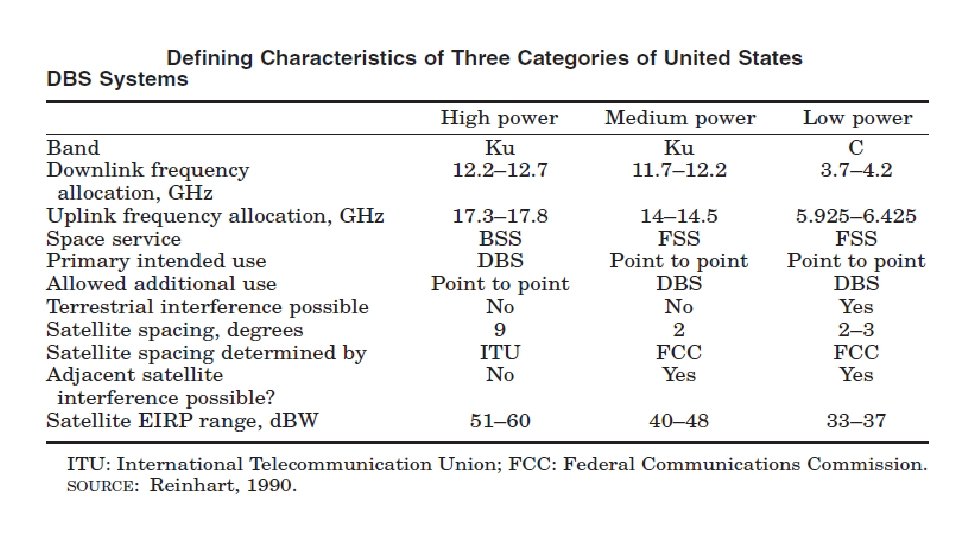

Minimum Orbital Spacing - DOMSAT • In 1983, the U. S. Federal Communications Commission (FCC) adopted a policy objective. • 2° as the minimum orbital spacing for satellites operating in the 6/4 GHz band • 1. 5° for those operating in the 14/12 -GHz band (FCC, 1983). • It is clear that interference between satellite circuits is likely to increase as satellites are positioned closer together.

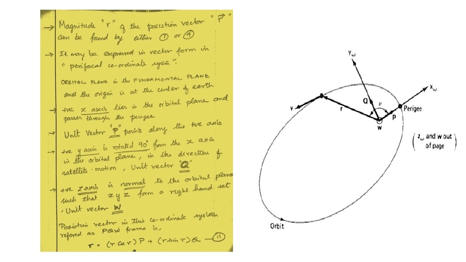
The orbital plane • The position vector r and the velocity vector v specify the motion of the satellite • the magnitude of the position vector is required which is given as • Eq 1: • The true anomaly v is a function of time, and determining it is one of the more difficult steps in the calculations

The geocentric-equatorial coordinate system • The perifocal system is very convenient for describing the motion of the satellite. • Only if the earth were uniformly spherical • But it is not like that (Effects of a nonspherical earth ) • These rotations are taken into account when the satellite position is transferred from perifocal coordinates to geocentric-equatorial coordinates. • The geocentric-equatorial coordinate system is an inertial system of axes, the reference line being fixed by the fixed stars. • The reference line is the line of Aries

The geocentric-equatorial coordinate system • THE FUNDAMENTAL PLANE IS THE EARTH’S EQUATORIAL PLANE. • Part of the ellipse is shown above the equatorial plane with the orbital angles Ω, ω, and i. • It should be kept in mind that they may be slowly varying with time

The geocentric-equatorial coordinate system • The unit vectors in this system are labeled I, J, and K, and the coordinate system is referred to as the IJK frame • With positive I pointing along the line of Aries. • The transformation of vector r from the PQW frame to the IJK frame is expressed in matrix form

The geocentric-equatorial coordinate system • where the transformation matrix is given by R • This gives the components of the position vector r for the satellite, in the IJK, or inertial, frame

Earth station referred to the IJK frame • The earth station’s position is given by the geographic coordinates of latitude λE and longitude ΦE. • North latitudes will be taken as positive numbers • South latitudes will be taken as negative numbers, • Zero latitude, being the equator. • Longitudes east of the Greenwich meridian will be taken as positive numbers, • Longitudes west of the Greenwich meridian will be taken negative numbers.

Earth station referred to the IJK frame • The position vector of the earth station relative to the IJK frame is R • R is a function of the rotation of the earth • The angle between R and the equatorial plane, is denoted by ψE • It is closely related, but not equal to, the earth station latitude • So first it is necessary to find the position of the Greenwich meridian relative to the I axis as a function of time • The angular distance from the I axis to the Greenwich meridian is measured directly as Greenwich sidereal time (GST), also known as the Greenwich hour angle (GHA)

Earth station referred to the IJK frame • The formula for GST in degrees is • Here, UT° is universal time expressed in degrees • T is the time in Julian centuries • Once GST is known, the local sidereal time (LST) is found by adding the east longitude of the station in degrees. • East longitude for the earth station will be denoted as EL. • For east longitudes EL = ΦE • For west longitudes EL = 360° + ΦE

Earth station referred to the IJK frame • For example, • For an earth station at east longitude 40°, EL = 40°. • For an earth station at west longitude 40°, • EL = 360 (- 40) = 320°. • Thus the local sidereal time in degrees is given by • LST = GST + EL • Knowing the LST enables the position vector R of the earth station to be located with reference to the IJK frame

Earth station referred to the IJK frame NOTE: • When R is resolved into its rectangular components, account must be taken of the oblateness of the earth. • The earth may be modeled as an oblate spheroid, • in which • the equatorial plane is circular, and • any meridional plane is elliptical,

IJK FRAME • For one particular model, known as a reference ellipsoid, • the semi major axis of the ellipse is equal to the equatorial radius, • the semi minor axis is equal to the polar radius, and • the surface of the ellipsoid represents the mean sea level. • Denoting • the semimajor axis by a. E • the semiminor axis by b. E and • using the known values for the earth’s radii gives • a. E = 6378. 1414 km • b. E = 6356. 755 km

IJK FRAME • From these values, the eccentricity of the earth is seen to be • Geocentric latitude is shown as ψE. • This differs from what is normally referred to as latitude. • An imaginary plumb line dropped from the earth station makes an angle λE with the equatorial plane • This is known as the geodetic latitude • For all practical purposes, this can be taken as the geographic latitude of the earth station.

IJK FRAME • With the height of the earth station above mean sea level denoted by H, • The geocentric coordinates of the earth station position are given in terms of the geodetic coordinates by Where

IJK FRAME • At this point, both the satellite radius vector r and the earth station radius vector R are known in the IJK frame for any position of satellite and earth. • the range vector ρ is • This gives ρ in the IJK frame. • It then remains to transform ρ to the observer’s frame, known as the topocentric-horizon frame

The topocentric-horizon coordinate system • The position of the satellite, as measured from the earth station, is usually given in terms of the azimuth and elevation angles and the range ρ. • These are measured in the topocentrichorizon coordinate system • THE FUNDAMENTAL PLANE IS THE OBSERVER’S HORIZON PLANE • The positive y axis points east, the unit vector being E. • The positive z axis is “up, ” pointing to the observer’s zenith, the unit vector being Z. • The frame is referred to as the SEZ frame, which rotates with the earth.

The topocentric-horizon coordinate system • The range vector ρ is known in the IJK frame, and it is now necessary to transform this to the SEZ frame. • the geocentric angle ψE is given by • For zero height, the angle ψE is known as the geocentric latitude and is given by • e. E is the earth’s eccentricity, equal to 0. 08182

The topocentric-horizon coordinate system • The difference between the geodetic and geocentric latitudes reaches a maximum at a geocentric latitude of 45°, when the geodetic latitude is 45. 192°. • Finally, the magnitude of the range and the antenna look angles are obtained from

The topocentric-horizon coordinate system • We define the angle α • Then the azimuth depends on which quadrant α is in and is given by

The sub satellite point • The point on the earth vertically under the satellite is referred to as the subsatellite point. • The latitude and longitude of the subsatellite point and the height of the satellite above the subsatellite point can be determined from a knowledge of the radius vector r. • The height of the terrain above the reference ellipsoid at the subsatellite point is denoted by HSS • The height of the satellite above this, by h. SS. • Thus the total height of the satellite above the reference ellipsoid is • h = HSS+h. SS

The subsatellite point IJK frame r replaces R, the height to the point of interest is h rather than H, and the subsatellite latitude λSS is used

The subsatellite point • The equation can be rewritten as • We now have three equations in three unknowns, LST, λE, and h, • The east longitude is found by EL = LST - GST
- Slides: 112