Earths Shape and Coordinate Systems Shape of Earth


 ► Math was Science and Science was")
 • Draw a solid line connecting each location point")


- Slides: 24
Earth’s Shape and Coordinate Systems
Shape of Earth ► Oblate Spheroid – flattened sphere § Flatter at the poles § Bulges at the equator ► Diagram of an oblate spheroid § Equatorial Circumference – 24, 900 mi § Polar Circumference – 24, 860 mi
Causes of Earth’s Shape ► Gravity – an inward pulling force; causes Earth to be spherical ► Centrifugal Force – an apparent outward pulling force; caused by spinning/rotating § Causes Earth to bulge at equator § As Speed , there is greater centrifugal force
Centrifugal Force ► How long does it take each location to rotate 360 o? ► Which location travels the greatest distance during a complete rotation? X ► Which Y location has a greater speed? ► Which location has a greater centrifugal force?
Evidence of Earth’s Shape ► Photographs: ► Ships almost a perfect sphere. over the horizon: evidence that the Earth is curved.
Evidence of Earth’s Shape ► Eclipse of the Moon: § As viewed form space: 2 From Earth: Earth’s Shadow 1 Position 2 Earth’s Shadow Full Moon Position 1 § As the moon orbits Earth it passes through earth’s shadow; showing a spherical shadow.
Evidence of Earth’s Shape ► Gravity: § Newton’s Law: gravity is greater when objects are closer to each other. § Where are you closer to the center? Equator Force of § Where would you weigh gravity more? § What would make me weigh the same everywhere on Earth?
Evidence of Earth’s Shape ► Polaris; the North Star § The altitude of Polaris changes as an observer moves north or south (N. Hemisphere. ) Altitude: height measured in degrees that a heavenly body is above the horizon to the observer. ► § This is due to Earth’s spherical shape and curved surface.
Altitude of Polaris Location 1 = 90 o N. Lat. Location 3 = 35 o N. Lat Location 2 = 60 o N. Lat. Location 4 = 0 o Lat Ø The altitude of Polaris is equal to the latitude of the observer. Ø Measure angel from equator and from horizon.
► Locating the North Star
Science and Math (bro’s from way back) ► Math was Science and Science was Math. § How philosophers, intellectuals and students connected with each other and tried to explain their observations of the Earth. ►Galileo, Newton, Einstein, Hawking ► Eratosthenes: Greek Mathematician § Determined the circumference of the Earth by observing shadows and established a set of ratios.
Eratosthenes (273 – 192 BC) • Draw a solid line connecting each location point to the center of the Earth • Measure angles with your protractor.
Eratosthenes’ Methods ► Method for determining Earth’s circumference: § Part Whole ► Earth’s Angle = Distance xo/360 o = d/c (circumference) other measurements: § Diameter: C = d § Radius: r = 1/2 d § Volume: (of a sphere) V = 4/3 r 3 § Area: A = 4 r 2
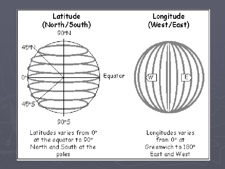
Latitude ► Angular distance North and South of the equator. § Equator: 0 o Latitude; starting place for North and South latitudes § North/South Poles: 90 o Latitude; maximum latitude on Earth. § Parallels: lines used to measure N & S latitude run: “east to west” ►Parallel to the equator ►
Latitude: Parallels ► Draw and label all parallels; using exact measurements to 90 o. North ► Color code labels ► 0 o
End Product
Longitude ► Angular distance east or west of the Prime Meridian. § Prime Meridian: 0 o Longitude; starting point for East and West longitude. Greenwich, England § International Date Line: 180 o Longitude; maximum measurement for longitude. ► Meridians: lines used to measure longitude; run north to south. § Lines converge at the poles.
Longitude: Meridians ► Mark dot. and draw a line every 15 o to center § Show direction (N. S. E. W. )
Earth’s Time Zones ► Half of the Earth Faces the sun at all times § ½ – Daylight ½ - Darkness ► When the sun is directly above any meridian (long) it is noon at or around that meridian. ► How fast is Earth’s rotational speed? ► How many time zones are on Earth?
International Date Line ► If it is Wednesday; traveling West across the IND; what day will it become? ► Tuesday; traveling East across IND; what day will it become?
Use the map below to determine the latitude and longitude of these numbered and lettered locations. Name the Continents and Oceans indicated by the letters.
Practice ► How many time zones? ► Earlier is CA or NY? ► 8 EST = ? PST ► 6 MST = ? EST
Reading a Map ► Complete the statements on pg 19 using the map provided.