Earthquakes Physical Geology Chapter 16 Tim Horner CSUS


")


 very large sea waves caused by sudden upward")


- Slides: 22
Earthquakes Physical Geology, Chapter 16 Tim Horner CSUS Geology Department
Earthquakes • An earthquake is a trembling or shaking of the ground caused by the sudden release of energy stored in the rocks beneath Earth’s surface – Tectonic forces within the Earth produce stresses on rocks that eventually exceed their elastic limits, resulting in brittle failure • Energy is released during earthquakes in the form of seismic waves – Released from a position along a break between two rock masses (fault) • Elastic rebound theory - earthquakes are a sudden release of strain progressively stored in rocks that bend until they finally break and move along a fault
Fault zone and earthquakes
Body Waves - Travel through the earth - 2 types, have different motion: Primary (P) waves • Particle motion is parallel to wave direction • Travel fastest (arrive first) • Travel through solid or fluid Secondary (S) waves • Particle motion is perpendicular to wave direction • Travel slightly slower • Only travel through solid
Surface Waves • Slowest type of seismic waves produced by earthquakes • Love waves - side-to-side motion of the ground surface – Can’t travel through fluids • Rayleigh waves - ground moves in an elliptical path opposite the direction of wave motion – Extremely destructive to buildings
Measuring Earthquakes • Seismometers - used to measure seismic waves • Seismographs - recording devices used to produce a permanent record of the motion detected by seismometers • Seismograms - permanent paper (or digital) records of the earthquake vibrations – Used to measure the earthquake strengths
Seismograph • Measures horizontal motion (P waves)
Locating Earthquakes • P- and S-waves leave earthquake focus at the same time • P-wave gets farther and farther ahead of the S-wave with distance and time from the earthquake • Travel-time curve - used to determine distance to focus – based on time between first P- and wave arrivals Insert revised Figs. 16. 8 a-d here S-
Locating Earthquakes • Plotting distances from 3 stations on a map, as circles with radii equaling the distance from the quake, locates earthquake epicenter • Depth of focus beneath Earth’s surface can also be determined – Shallow focus 0 -70 km deep – Intermediate focus 70 -350 km deep – Deep focus 350 -670 km deep
Measuring the “Size” of Earthquakes • Earthquake “size” measured two ways - intensity and magnitude • Intensity - a measure of the effects an earthquake produces (on both structures and people) – Modified Mercalli scale
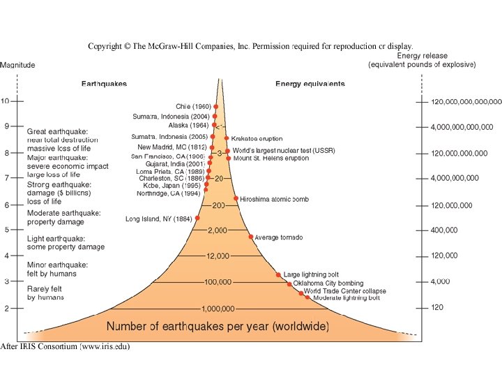
Measuring the “Size” of Earthquakes • Size of earthquakes measured in two ways - intensity and magnitude • Magnitude is a measure of the amount of energy released by an earthquake – Richter scale • Moment magnitude - more objective measure of energy released by a major earthquake – Uses rock strength, surface area of fault rupture, and amount of movement – Smaller earthquakes are more common than larger ones
Effects of Earthquakes • Earthquakes produce several types of effects, all of which can cause loss of property and human life – Ground motion is the familiar trembling and shaking of the land during an earthquake • Can topple buildings and bridges – Fire is a problem just after earthquakes because of broken gas and water mains and fallen electrical wires – Landslides can be triggered by ground shaking, particularly in larger quakes – Liquefaction occurs when watersaturated soil or sediment sloshes like a liquid during a quake
Tsunami • Tsunami (seismic sea waves) very large sea waves caused by sudden upward or downward movement of the sea floor during submarine earthquakes – generally produced by magnitude 8+ earthquakes (“great” earthquakes e. g. , 9. 3 Indonesia, 2004) – May also be generated by large undersea landslides or volcanic explosions – Travel across open ocean at speeds of >700 km/hr – Reach great heights in coastal areas with gently sloping seafloor and funnel-shaped bays
World Earthquake Distribution • Most earthquakes occur in narrow geographic belts which mark tectonic plate boundaries • Most important concentrations in circum-Pacific and Mediterranean. Himalayan belts • Shallow-focus earthquakes common along the crests of mid-oceanic ridges • Nearly all intermediate- and deep-focus earthquakes occur in Benioff zones – inclined seismic activity associated with descending oceanic plate at subduction zones)
Earthquakes and Plate Tectonics • Earthquakes are caused by plate interactions along tectonic plate boundaries • Plate boundaries are identified and defined by earthquakes • Earthquakes occur at each of the three types of plate boundaries: divergent, transform, and convergent – At divergent boundaries, tensional forces produce shallow-focus quakes on normal faults – At transform boundaries, shear forces produce shallow-focus quakes along strike-slip faults – At convergent boundaries, compressional forces produce shallow- to deep-focus quakes along reverse faults
Location and Size of Earthquakes in the U. S. • Earthquakes occur throughout the U. S. , but are much more common in the western states and Alaska • Largest seismic risks or hazards exist near the plate boundary along the U. S. Pacific coast (e. g. , San Andreas fault), and around New Madrid, Missouri • Seismic risk determined based on the assumption that large future earthquakes will occur where they have occurred in the past Earthquake locations since 1977
Earthquake Prediction and Seismic Risk • Accurate and consistent short-term earthquake prediction not yet possible, three methods assist in determining probability that an earthquake will occur: – Measurement of changes in rock properties, such as magnetism, electrical resistivity, seismic velocity, and porosity, which may serve as precursors to earthquakes – Studies of the slip rate along fault zones – Paleoseismology studies that determine where and when earthquakes have occurred and their size • Average intervals between large earthquakes and the time since the last one occurred can also be used to assess the risk (over a given period of time) that a large quake will occur
Earthquakes near Sacramento Santa Rosa: 1969, M 5. 6 Livermore: 1980, M 5. 9 Morgan Hill: 1984, M 6. 2 Loma Prieta: 1989, M 7. 1 Vacaville-Winters: 1892, M 6 -7 Coalinga: 1983, M 6 -7 Oroville: 1975, M 5. 7
Faults in the Sierra Nevada Mtns
Foothills Seismicity
Tahoe Seismicity