EARTHQUAKES FORCES IN EARTHS CRUST How does stress


 Upward and downward fold in rock. A")


")


- Slides: 63
EARTHQUAKES FORCES IN EARTH’S CRUST
How does stress change Earth’s crust? Stress is a force that acts on rock to change its shape or volume. Stress= force / unit of area Pressure = Force / Area
The movement of Earth’s plates can create strong forces that slowly bend or fold many rocks like a caramel candy bar.
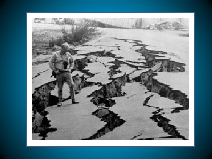
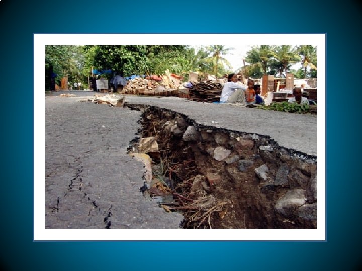
An earthquake is the shaking of the ground cause by seismic waves.
Tension, compression and shearing work over millions of years to change the shape and volume of a rock.
TENSION occurs where two plates pull apart. The stress force that pulls on the crust and thins rock in the middle is called tension.
COMPRESSION occurs where two plates come together. The stress force that squeezes rock until it folds or breaks.
SHEARING occurs where two plates slip past each other. Shearing can cause rock to break and slip apart or to change its shape.
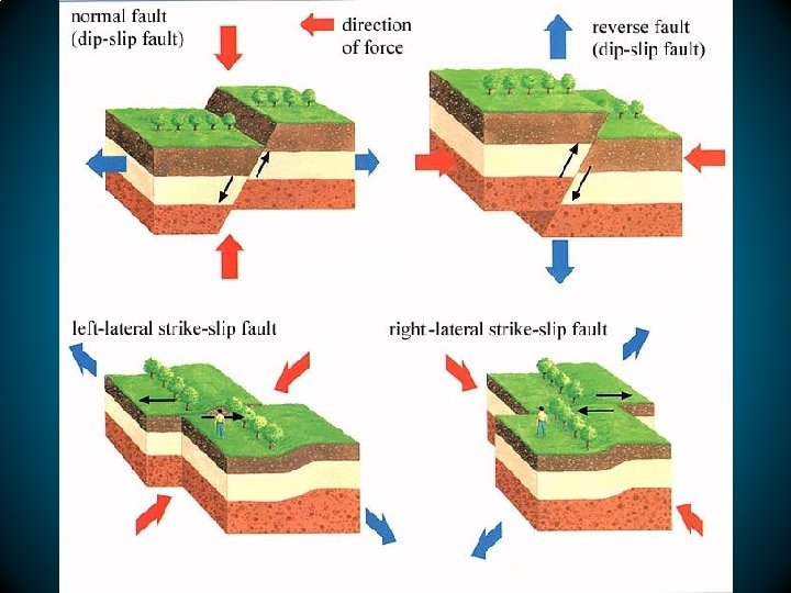
HOW DO FAULTS FORM? When enough stress builts up in rock, the rock breaks, creating a fault.
Normal Fault. - Rock is pull apart by tension. The fault cuts through rock at an angle, so one block sits over the fault ( hanging wall) and the other block lies under the fault ( footwall). RIO GRANDE RIVER flows through a wide valley in Mexico.
NORMAL FAULT
REVERSE FAULTS. - The blocks move in the reverse direction. The hanging wall moves up and the footwall moves down. R. F. form where compression pushes the rock of the crust together. The northern Rocky Mountains rise high above the Western United States and Canada.
STRIKE-SLIP FAULT. – The rocks slip past each other sideways, with little up or down motion. They form when compression pushes the rock of the crust together. The hilly plains in Southern California. San Andreas fault is an example of a transform boundary.
Type of faults
SAN ANDREAS FAULT
1 1. 2. 2 3 Normal Fault. - hanging wall slips down relative to the footwall. Reverse Fault. -The hanging wall moves up relative to the footwall. 3. Strike-slip fault Rocks on either side 4. Of the fault move past to each other.
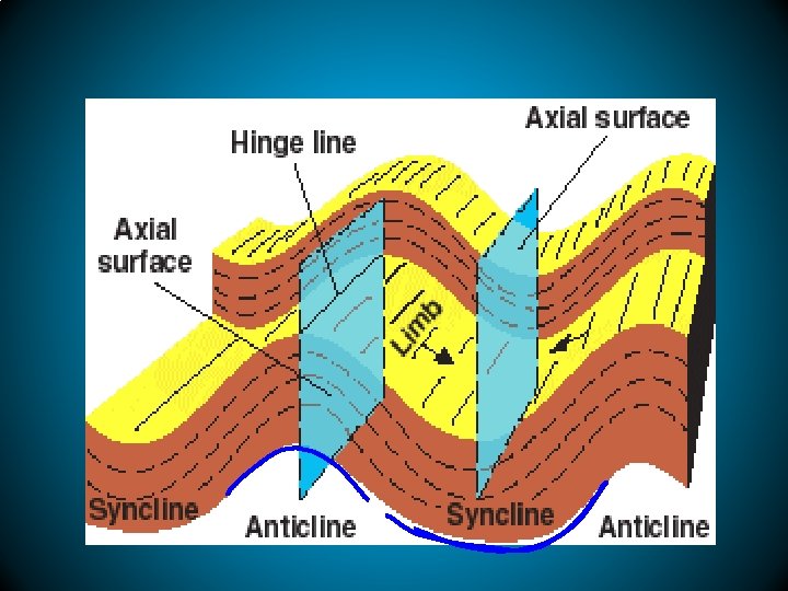
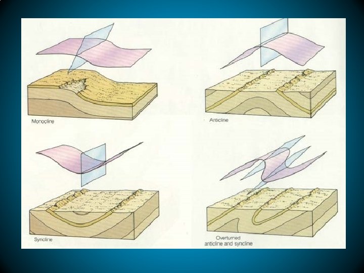
Plate movements create new landforms Over millions of years, the forces of plate movement can change a flat plain into features such as : anticlines and synclines, folded mountains, fault-block mountains, and plateaus.
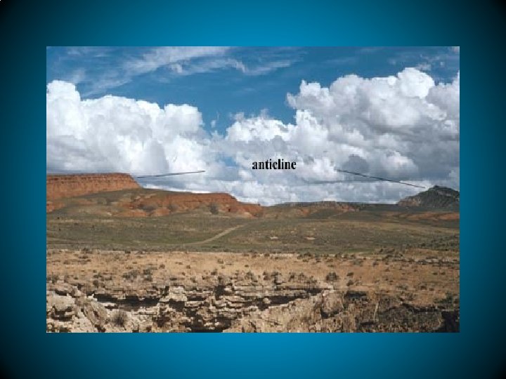
ANTICLINE
ANTICLINE
FOLDS are bends in rock that form when compression shortens and thickens Earth’s crust. A fold can be a few centimeters across or hundreds of kilometers wide.
ANTICILINES AND SYNCLINES ( By Compression forces) Upward and downward fold in rock. A fold in rock that bends downward in to form a V shape is a syncline. The central Appalachian Mountains in Pennsylvania.
EARTHQUAKES PLATE MOVEMENT
SYNCLINES
SYNCLINES
FOLDED MOUNTAINS Collision of plates , compression and folding of crust over a wide area. Largest Mountain Ranges: Himalayas ( Asia ), Alps ( Europe )
FOLDED MOUNTAINS
Folded mountains/ anticiclines
Salt Lake City to Los Angeles Cross the Great Basin , region with many mountains, valleys or basins. Region formed by tension and faulting. Fault-block mountains formed where two plates move away from each other.
SALT LAKE CITY/ UTAH
GREAT BASIN. NEVADA
GREAT BASIN NATIONAL PARK NEVADA
GREAT BASIN /NEVADA
PLATEAUS Large area of flat land elevated high above sea level. Forces that raise mountains , uplift a large flat block of rock ( crust). Plateaus have many different flat layers. Colorado Plateau in the “Four Corners” , regions of Colorado, Utah , Colorado and New Mexico.
COLORADO PLATEAU
LESSON 2
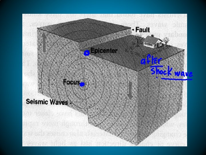
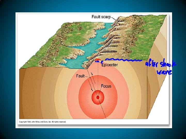
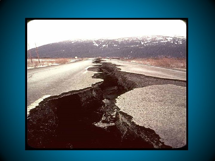
EARTHQUAKE is the shaking and trembling that results from movement of rock beneath Earth’s surface.
LOMA PRIETA. - SAN FRANCISCO
SEISMIC WAVES are vibrations, that are similar to sound waves. They travel through Earth carrying energy released by an earthquake.
TYPES OF SEISMIC WAVES • Focus point • Epicenter • P waves. - waves that compress and expand • S Waves. - waves that vibrate side to side. Vibrations at an angle 90 to the direction that they travel.
P Waves travel through liquids and solids. S waves can not move through liquids. S waves reached the surface and shake structures violently. Surface waves are P or S waves that reach the surface. S. W. move more slowly than P or S waves, but they can produce sere ground movements.
KABUL INDU KUSH REGION ( AFGHANISTAN )
Most earthquakes start in the lithosphere within about 100 Km. beneath Earth’s surface. Seismic Waves carry energy.
P WAVES CAN VIBRATE THE GROUND SIDE TO SIDE S WAVES CAN MAKE THE GROUND ROLL LIKE THE OCEAN WAVE SURFACE WAVES CCOMPRESS AND EXPAND THE GROUND
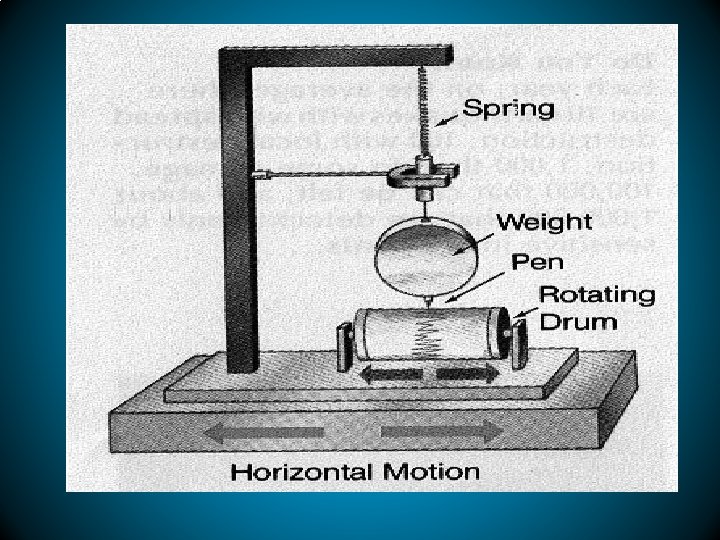
SEISMOGRAPH is an instrument that records and measures an earthquake’s seismic waves.
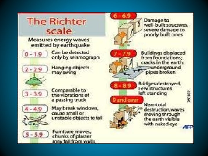
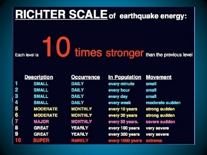
The magnitude or size of an earthquake is measured on a seismograph using the RICHTER scale.
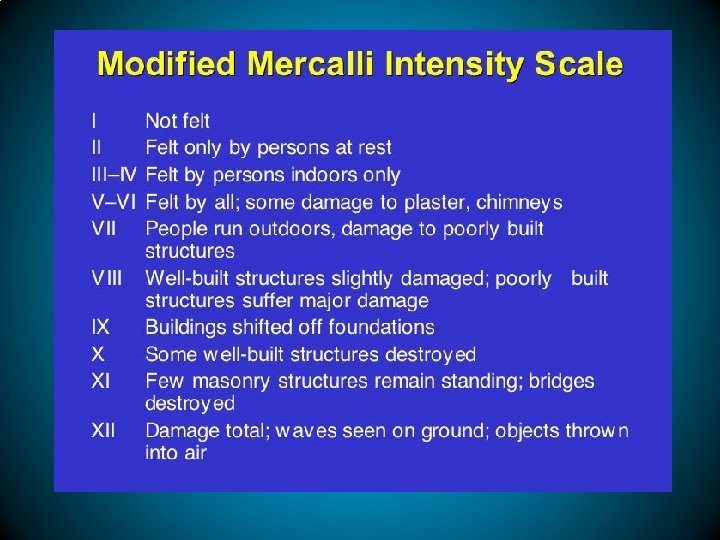
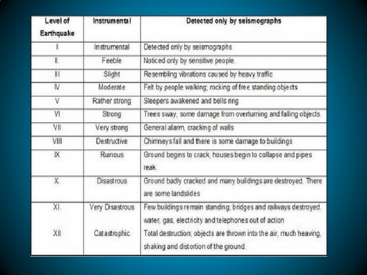
The amount of earthquake damage or shaking is rated using the Modified Mercalli scale.
The Moment Magnitude Scale rates the total energy an earthquake releases.