Earth to Globe to Map Scale Map Projection

Earth to Globe to Map Scale: Map Projection: Scale Factor, k Representative Fraction = Globe distance Earth distance (e. g. 1: 24, 000) = Map distance Globe distance (e. g. 0. 9996)

Extent of New Zealand 34°S to 48°S Central Meridian 166°E to 179°E

Transverse Mercator Projection A cylinder surrounding the earth and touching it on one Meridian For New Zealand, this meridian (line of constant longitude) is 173°E
 (0°, 173°E) (1600000, 10000000) Latitude of Origin =")
New Zealand Transverse Mercator Projection (NZTM) (0°, 173°E) (1600000, 10000000) Latitude of Origin = 0° Origin: Latitude = 0° Longitude = 173°E False Easting (X) = 1, 600, 000 False Northing (Y) = 10, 000 Central Meridian = 173°E UC Engineering Building (1566365, 5181181)

UC Engineering Building NZTMX =1566365 NZTMY = 5181181
 coordinates https: //www. linz. govt. nz/data/geodetic-system/datums-projections-and-heights/projections/new-zealand-transverse-mercator-2000")
Establishes horizontal location as (X, Y) coordinates https: //www. linz. govt. nz/data/geodetic-system/datums-projections-and-heights/projections/new-zealand-transverse-mercator-2000

Representations of the Earth The Geoid is a surface of constant gravitational potential Sea surface Ellipsoid – NZ uses a standard ellipsoid called GRS 80 Earth surface Geoid

Plate Tectonic Movement

New Zealand Geodetic Datum Establishes vertical location as Z-coordinate
 (these are “true”")
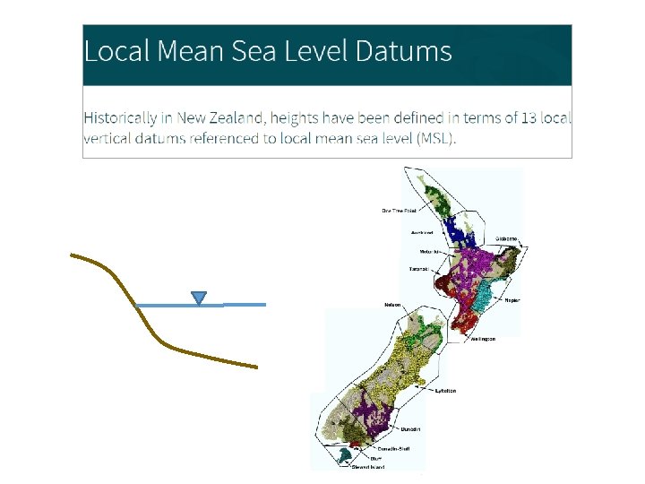
NZ Vertical Datums Orthometric heights: produced using a Geoid (NZVD 2016) (these are “true” heights for water flow) Tidal heights: derived from tide gages—related to sea level Ellipsoidal heights: produced by GPS on GRS 80 ellipsoid (abundant data)
- Slides: 11