Earth Science Layers of the Earth The Earths


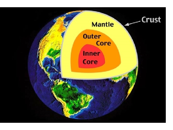
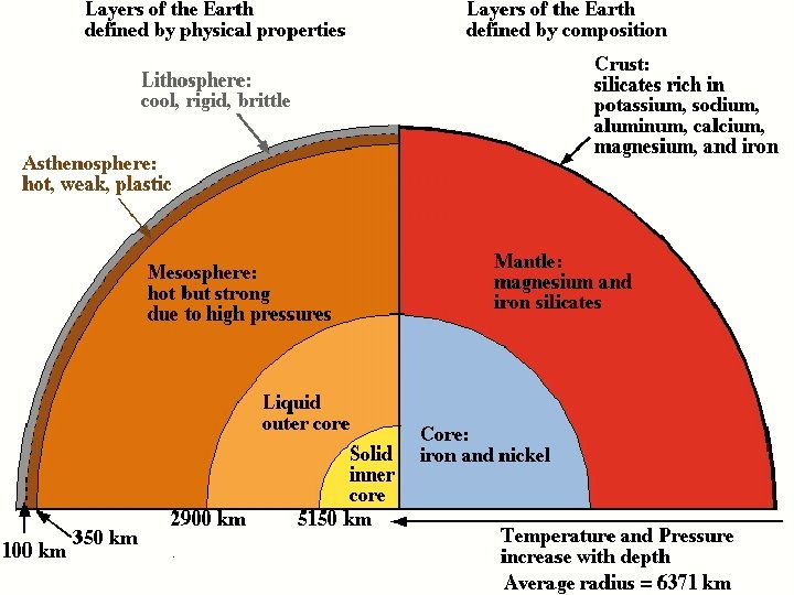


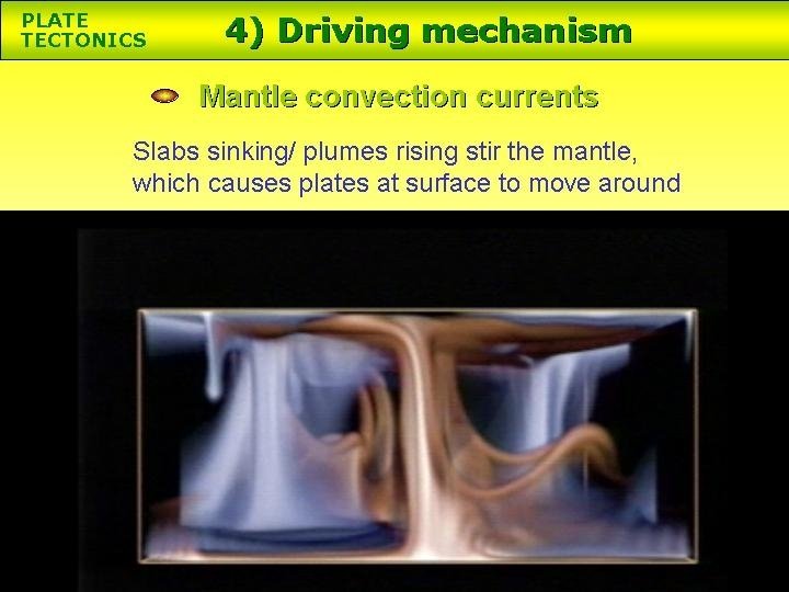


 Plate boundaries l Divergent boundaries Mostly mid-ocean ridges (seafloor spreading) Typical")


 Plate boundaries l Divergent boundaries Also found where continents break apart")
 Plate boundaries Red Sea (looking southeast)")
 Plate boundaries l Divergent boundaries Continents breaking apart Example: East African")
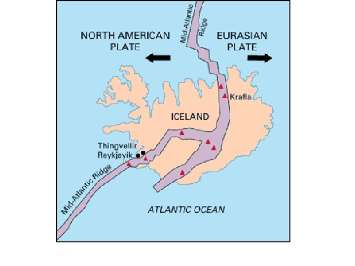

 Plate boundaries")


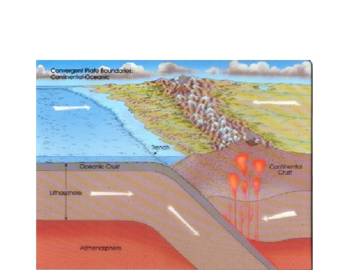
 Plate boundaries l Transform fault boundaries Strike-slip faulting Plates slide past")


 are examples of fault block")


- Slides: 94
Earth Science Layers of the Earth
The Earth’s Layers
Lithosphere • The top part of the layer is the Earth’s crust. • The outermost layer of the earth known as the “rock sphere” that we live on. • It is divided into pieces called tectonic plates
Asthenosphere • The soft layer of the mantle below the lithoshphere. • Tectonic plates move above this layer.
Outer Core • The liquid layer below the earth’s mantle. • This layer surrounds the inner core.
Inner Core • The solid, dense center of our planet. • It is about 6, 374 km. beneath the earth’s surface.
“Plate tectonics” Theory: u explains motion/behavior of Earth’s lithosphere u. Moves a few centimeters a year u explains volcanoes, mountain building and earthquakes ustiff lithosphere floats on top of weak asthenosphere
Plate tectonics u about a dozen or so plates
Supporting evidence Modern measurements
EARTH is a Heat Engine What drives the plate movement?
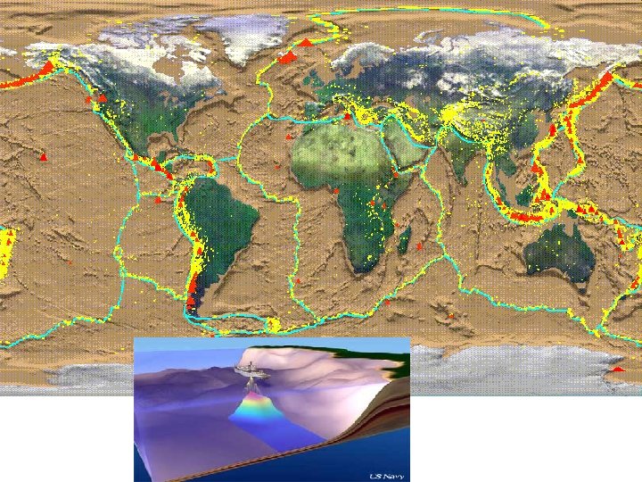
Tectonic Plates • The place where two tectonic plates meet is called a plate boundary.
Plate Boundaries 3 types l divergent boundaries l convergent boundaries l transform fault boundaries
• http: //www. wwnorton. com/college/geo/eart h 2/content/chapter_4/animations. asp
PLATE TECTONICS 2) Plate boundaries l Divergent boundaries Mostly mid-ocean ridges (seafloor spreading) Typical spreading rates ~ 5 cm/year As oceanic moves away from ridge, it cools, & becomes denser Also found where continents break apart Example: Red Sea and East African Rift
Mid Ocean Ridges http: //earthquake. usgs. gov/learning/animations/
Continents Break Apart – Rift Valley
PLATE TECTONICS 2) Plate boundaries l Divergent boundaries Also found where continents break apart Example: Red Sea http: //www. wwnorton. com/college/geo/an imations/sea_floor_spreading. htm
PLATE TECTONICS 2) Plate boundaries Red Sea (looking southeast)
PLATE TECTONICS 2) Plate boundaries l Divergent boundaries Continents breaking apart Example: East African Rift Red triangles show the active volcanoes and the Afar Triangle (shaded, center)
Divergent Plate Boundaries
PLATE TECTONICS 2) Plate boundaries
Convergent Plate boundaries l Convergent boundaries Subduction zones ocean-continent - Volcanoes Examples: Mount St. Helens ocean-ocean - Volcanic island arcs Examples: Marianas, Aleutians, Hawaii continent-continent - Mountain Building Examples: Himalayas, Alps, Appalachians
continental crust and continental crust • Mountain building
Oceanic and oceanic crust • DEEPEST Trenches and Island Arcs Oceanic crust
Continental Crust and Oceanic Crust • Trenches and explosive volcanoes volcano Oceanic crust Continental crust Molten rock SUBDUCTION ZONE
• Mountains • Volcanoes, trenches & earthquakes
PLATE TECTONICS 2) Plate boundaries l Transform fault boundaries Strike-slip faulting Plates slide past each other: no production/destruction of material
STRESS • Stress occurs at plate boundaries. Stress causes rock to change shape or deform (deformation) Types of Stress: Type of boundary – Compression convergent – Tension divergent – Shearing transform
Stress Causes Deformation Bends and Breaks Rock
If you bump your bike into a large rock two things can happen. The metal can either bend or snap.
Stress Cause - Compression Effect: Folding • Folding- When rock layers bend because of stress on the earth’s crust. The types of folding are:
Folding • Anticline- Arch shape folds in the earths’ crust. pushing • Syncline- Trough shaped fold in a rock. pushing
Monocline • Monocline – simplest - involves a slight bend on one side
Anticline
Anticline
Anticline
Folding • Syncline- Trough shaped fold in a rock.
Syncline
Syncline
Syncline
Syncline
Syncline
Monocline • Monocline – simplest - involves a slight bend on one side
Monocline
Monocline
Monocline
Monocline
Monocline
Tectonic Plates • The place where two tectonic plates meet is called a plate boundary. (When there is enough pressure that builds up on the rocks’ edges and earthquakes can occur). • Earthquake Facts
Earthquake Animation
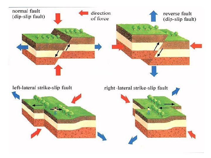
Tectonic Forces • Faulting- Stress that causes rocks to break • Faults slide past each other. • The types of faulting are: - normal fault - reverse fault - strike-slip fault
Fault Type #1: Normal Fault Cause: Tension/ Divergent movement Normal Faults- Effect: The hanging wall moves down, relative to the footwall. Normal because of the pull of gravity.
Normal Fault
Normal. Fault
Normal Fault
Fault Type #2: Reverse Fault Cause: Compression/ Convergent Movement Reverse Fault- Effect: The hanging wall moves up relative to the footwall.
Reverse Fault
Reverse Fault
Reverse Fault
Reverse Fault
Strike-Slip Fault Cause: shearing/ crosswise movement Strike-slip Faults- Effect: When opposing forces cause rock to break and move horizontally.
Strike Slip Fault
Strike Slip Fault
Strike Slip Fault San Andreas Fault
• US Geological Survey scientist Chris Mountain Building Newhall attaches a tape measure to a cliff Cause: Compression on Bubuin Island. Activity from nearby Effect: – crust is raised to higher Volcano. Uplift Island has lifted Bubuin by 15 centimeters elevation
Grand Canyon
Folded Mountains • In a folded mountain range, the rock layers are folded up.
Folded Mountains • Fault-Block • Folded • Volcanic
Folded Mountains Sierra Nevada
Folded Mountains Appalachian
Folded Mountains Appalachian Mountains
Fault-Block. Mountains • Fault-Block
Fault- Block Mountians • Rock layers are tilted up and can have sharp jagged peaks.
Fault-Block Mountains Grand Tetons from Jackson Lake Lodge (WY) are examples of fault block mountains.
Fault Block Mountain
Fault-Block Mountains • Big Bend Texas
Volcanic Mountains • Volcanic mountains are often cone shaped, and form along convergent boundaries. • Also forms along the divergent sea floor spreading
Volcanic Mountains
Volcanic Mountains • Mt. Ranier, Washington
Volcanic Mountains Mt. St. Helens, Washington
Volcanic Mountains Mt. Shasta, California
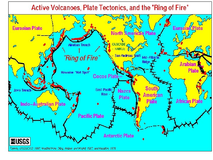
Volcanic Mountains • Volcanic mountains of Guatemala make up part of the Pacific's "Ring of Fire".
Popocatepetl, Mexico. December 12, 2007 this volcano spewed lava and ash two miles high.
Volcanic Mountains • Mt. St. Helens- Live
• On May 18, 1980, Mount St. Helens violently erupted. For 2 months the volcano showed signs that it was waking up from its 123 -year sleep. • Earthquakes beneath the mountain increased. Steam and ash erupted. • And a "bulge" grew on the mountain's steep north side. All these warning signs signaled that magma was moving upward inside the volcano.
US Volcanoes • Cascade Range Volcanoes • Major West Coast Volcanoes • Hawaii Volcano Map