Dynamic Soil Properties in Soil Survey Skye Wills


- Slides: 25
Dynamic Soil Properties in Soil Survey Skye Wills NC-CSS
DSPs in Soil Survey Dynamic Soil Properties Those soil properties that change with land use and management.
DSPs in Soil Survey Dynamic Soil Properties in Soil Survey Millennia Centuries Decades Richter and Markowitz, 2001 Soil Survey can document properties that change on the human time scale – decades to centuries.
DSPs in Soil Survey Soil Change Guide Current guidance – used as a reference but should not be considered prescriptive
DSPs in Soil Survey Dynamic Soil Property: within Soil Survey 5 year plan Tech Team: representatives from NSSC, regions, SSOs, modeling units, tech centers and state offices Action Teams Products, Data Needs, DSP terminology and definitions, Data collection, Data Business Systems Support
DSPs in Soil Survey DSP Products Team Collecting feedback from a range of backgrounds Two trains of thought Rigorous, complex and scientifically defensible Easy and simple (allow for speedy production) Will add finished projects to Soils DSP page
DSPs in Soil Survey DSP past projects Project Name Big Bend Georgia-Tifton Longleaf Comparison Idaho Dynamic Properties MO Pilot Nebraska MRLA 106_Kennebec-Nodaway project Oklahoma MRLA 80 A Tabler DSP Project South Dakota - DSP ranges for multiple soil Series Texas MLRA 77 A (SHP) Amarillo DSP Project Utah Begay Soil Pilot
DSPs in Soil Survey DSP Data Collection Refine current guidance while working with ongoing projects Request for project proposal/plans issued through edirectives Targeted State Soil Scientist and technical soil services
DSPs in Soil Survey New 2014 DSP Projects Project Name Response of dynamic soil properties to stand structure on Vassar series, Idaho Indiana Soil Health DSP-Moody – Nora – Alcester Catena Ksat Project (NE) DSP – Hydric Soils in Restored Wetlands (MI) Kansas Irrigation Dynamic Soil Property Proposal
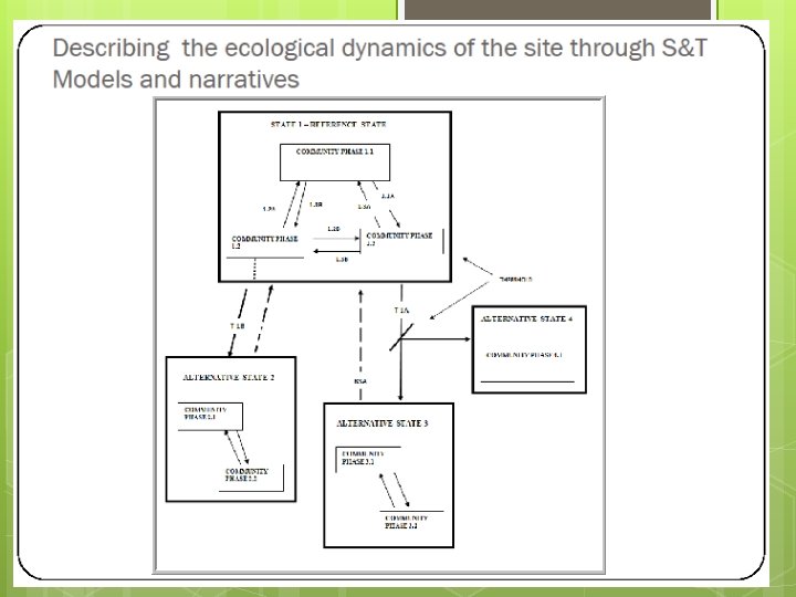
DSPs in Soil Survey DSPs as Part of Ecological Site Inventory DSPs are an important part of ecological feedbacks and thresholds
DSPs in Soil Survey Ecological Sites An ecological site is a distinctive kind of land based on: • recurring soil, landform, geological, and climatic characteristics that differs from other kinds of land • its ability to produce distinctive kinds and amounts of vegetation, and • its ability to respond similarly to management actions and natural disturbances.
Example STM: Post oak/blackjack oak/little bluestem Hot summer burn and /or long-term grazing Burn, Site prep & Planting / Seeding. No grazing or limited controlled grazing Post oak/flowering dogwood/ tick trefoil-goldenrod. Multistory. Canopy: 30 -90% Harvest, site prep, seeding Forest Westoby, et. al. , 1989 Stringham et. al. , 2001 Post oak/buckbrush (or similar) Lacks mid-story. Understory single species woody dominated Canopy: open 30 -90% Pasture Abandonment for 20+ yr with recruitment of woody natives Pasture (improved) Non-native grass sod
DSPs in Soil Survey DPSs and ESI and Soil Survey Working to incorporate these ideas into soilsystems approach and ecological hierarchies MLRA LRU Characteristic Catena Landscape Elements Benchmark Soil – soils that behave similarly, target for DSPs etc.
Examples of Soil System Graphics Matt Havens, NY SGI, 2008, PA Pacolet Chestatee fra er er inn 15 % gs. Cecil ) ye llo w er ro ck ki th (> ro c Appling Daniels et al. , 1999. th ye llo in w er ne r Wedowee Daniels et al. , 1999.
Soil Systems : Discussion To by O’G e en , U C- Da vis (C. Hibner, A. Miller; SGI, 2008)
The shore-to-upland Ecological Sites, Landforms, Soil Types and Hydropedology of Little Narragansett Bay, RI. Proposed Ecological Site : Subaqueous Flat Grass Barrier Island/Dune Subaqueous Flat Subaqueou s Grass Slope Subaqueous Algae Bottom Subaqueous Rock Weed Headland barrier island washoverfan flat washoverfan slope bay bottom submerged headland Landforms: shore Mixed Hardwood Till Upland moraine (till) Ground water recharge from the aquifer of the sandy loose till Mean high water level of saltwater Atlantic Ocean Mean lower low level of saltwater n sio er sp Di of ne Zo Freshwater discharged into saltwater by through flow; sands act as an aquifer f A horizon Buried A horizon Saltwater and freshwater mix in the zone of dispersion by the process of diffusion and mechanical dispersion. Rhodesfolly Hooksan Zo ne of Di sp er sio n Higher silts, clays, sulfidic materials present due to low energy water movement. freshwater saltwater Soils: r ate hw res Rhodesfolly Pishagqua Napatree Freshwater flows downhill by through flow, then discharged producing aeric conditions (orange). Freshwater flows above the more dense saltwater in soil. Canton Modified from Debbie Surabian, NRCS, SGI, 2012
DSPs in Soil Survey DPSs and ESI and Soil Survey Working to incorporate these ideas into soilsystems approach and ecological hierarchies MLRA LRU Characteristic Landscape Elements l ica g olo es c E Sit Catena Benchmark Soil – soils that behave similarly, target for DSPs etc.
DSPs in Soil Survey DSPs as Part of Ecological Site Inventory DSPs are an important part of ecological feedbacks and thresholds Need alternative ways to document and describe ecological sites that are dominated by agriculture (or other high-input management)
DSPs in Soil Survey Highly Managed Ecological Sites For cropland systems we propose a model for organizing, analyzing and presenting DSP information
Attainable for Forage Crops Production Group Forage Crops Ecological Potential Degradation / Resilience Threshold Low Native/ Naturalized States Agricultural Production Groups Vegetable Rotation Resource Concern Threshold Root Crops Grain Rotation Attainable for Grain Rotations Production Group Native / Naturalized Plant Communities Soil Functions / Ecosystem Services High
Attainable for Grain Rotations Production Group Grain Rotations Soil Functions / Ecosystem Services Ecological Potential Continuous no-till w/ cover crops Organic system w/ cover crops Resource Concern Threshold Rotation, low-till, no cover crops Diverse rotation, tillage Degradation / Resilience Threshold Monocrop, Deep tillage Disturbance within one Agricultural Production Group
High Trends in Condition Soil Function / Ecosystem Service Inherent Potential Attainable for Grain Production Group Best Management System Production Group A Alternate Management System Resilience Threshold Worst Management System Degrading / worst Management System Time
DSPs in Soil Survey Potential to provide value added information to current products Provide context and support to soil health efforts Integrate ecological site concepts where vegetation is highly managed Tech team is working with new projects to develop and test new guidance Work to meet local, regional and national objectives
DSPs in Soil Survey Questions