DISASTER MANAGEMENT for Earthquake floods volcanic eruption DISASTROUS


 • Mitigation and preparedness phases occur as disaster")
 •")


: returning vital life-support systems to minimum")


")


 mencatat telah")

")


 Where Most earthquakes occur along the edge of the oceanic")


 to Magnitude: measure. Richter Scale • • Measures the")
 Intensity: Mercalli Scale: • What did you feel? • Assigns an intensity or")


 1. Foreshocks: usually increase in magnitude")


 • 1. Aktif Normal (Level I) •")
 • Berdasarkan hasil pengamatan visual, pemeriksaan kawah, kegempaan")


- Slides: 75
DISASTER MANAGEMENT, for Earthquake, floods, volcanic eruption DISASTROUS CONSEQUENCES AND IMPACT ON ENVIRONMENT AND HUMAN HEALTH AND EMERGENCY RESPONSE
DISASTER MANAGEMENT • Disaster management aims to reduce, or avoid, the potential losses from hazards, assure prompt and appropriate assistance to victims of disaster, and achieve rapid and effective recovery
DISASTER MANAGEMENT CYCLE • Disaster management cycle : the ongoing process by which governments, industries/businesses, and civil society plan to reduce the impact of disasters, react during and immediately following a disaster, and take steps to recover after a disaster has occurred
Complete disaster management cycle: • public policies and plans • modify the causes of disasters • mitigate their effects on people, property, and infrastructure.
Anticipation of a disaster event (Pre-disaster) • Mitigation and preparedness phases occur as disaster management improvements
Disaster management phase ( four phases, not olways in order, but often overlap) • The four disaster management phases often overlap and the length of each phase greatly depends on the severity of the disaster.
4 phases of disaster management cycle: • Mitigation - Minimizing the effects of disaster. Examples: building codes and zoning; vulnerability analyses; public education. • Preparedness - Planning how to respond. Examples: preparedness plans; emergency exercises/training; warning systems. • Response - Efforts to minimize the hazards created by a disaster. Examples: search and rescue; emergency relief. • Recovery - Returning the community to normal. Examples: temporary housing; grants; medical care.
MITIGATION • eliminate or reduce the probability of disaster occurrence, • or reduce the effects of unavoidable disasters. Mitigation measures include building codes; vulnerability analyses updates; zoning and land use management; building use regulations and safety codes; preventive health care; and public education.
MITIGATION • Mitigation will depend on appropriate measures in development planning and the availability of information on hazards, emergency risks, and the countermeasures to be taken. .
Preparedness • to achieve a satisfactory level of readiness to respond to any emergency situation through programs that strengthen the technical and managerial capacity of governments, organizations, and communities. • logistical readiness to deal with disasters and can be enhanced by having response mechanisms and procedures, rehearsals, developing long-term and short-term strategies, public education and building early warning systems
Preparedness measures: • preparedness plans • emergency exercises/training • warning systems • emergency communications systems • evacuations plans and training • resource inventories • emergency personnel/contact lists • mutual aid agreements • public information/education.
RESPONSE • provide immediate assistance to maintain life, improve health and support the morale of the affected population. • assisting refugees with transport, temporary shelter, and food, to establishing semi-permanent settlement in camps and other locations, initial repairs to damaged infrastructure. • The focus to provide basic needs of the people until more permanent and sustainable solutions can be found.
RECOVERY • Recovery measures (short and long term): returning vital life-support systems to minimum operating standards: temporary housing; public information; health and safety education; reconstruction, counseling programs; and economic impact studies. • Information resources and services include data collection related to rebuilding, and documentation of lessons learned.
TSUNAMI AND NUCLEAR POWER PLANT DISASTER
FUKUSHIMA DISASTER • A tanker that crashed into the bridge linking Kansai International Airport with the mainland in Osaka Prefecture is pictured in this photo taken from a Mainichi Shimbun helicopter on Sept. 4, 2018. (Mainichi)写真: 1 枚目(計 2 枚)
Tsunami (Fukushima)
Tsunami Fukushima
5 years after fukushima incidence
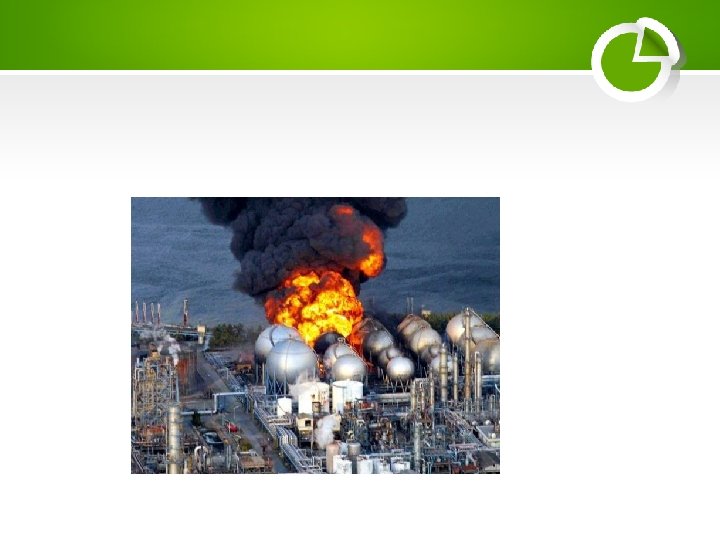
• The Fukushima Daiichi Nuclear Disaster. What happened? The Great East Japan Earthquake (magnitude 9. 0) occurred on March 11, 2011 at 2. 46 pm and did considerable damage in the region. The large tsunami it created caused significant damage as well. Fukushima Daiichi was one four nuclear power plants with eleven reactors between them in the region operating at the time and all shut down automatically when the quake hit.
The reactors held up to the seismic activity of the earthquake, but were vulnerable to the tsunami. Power, from grid or backup generators, was available to run the Residual Heat Removal (RHR) system cooling pumps at eight of the eleven units, and despite some problems they achieved ‘cold shutdown’ within about four days.
• The other three, at Fukushima Daiichi, lost power at 3. 42 pm, almost an hour after the quake, when the entire site was flooded by the 15 -metre tsunami. This disabled 12 of 13 back-up generators on site and also the heat exchangers for dumping reactor waste heat and decay heat to the sea. The three units lost the ability to maintain proper reactor cooling and water circulation functions. It took weeks to stabilize the reactors.
Fire disaster response
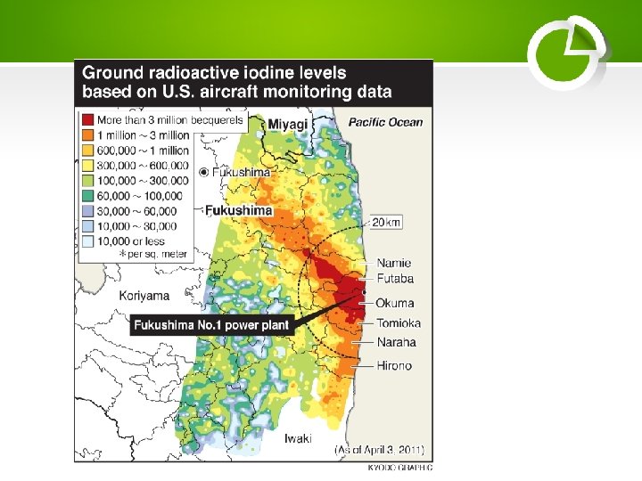
• Evacuation and Radiation: The government issued an evacuation instruction for residents within 3 km radius in the beginning. Eventually it was expanded to within 20 km, and the residents of a range of 20 km -30 km were instructed to stay indoors. There have been no deaths or cases of radiation sickness from the nuclear accident, but over 100, 000 people were evacuated from their homes to ensure this. Government
Radiation after Fukushima Nuclear Fallout
• In 2014 the radiation on California beaches increased by 500%. In response, government officials said that the radiation came from a mysterious source and “unknown” and was not a concern. • However, Fukushima will not have a major impact only on the west coast of North America, scientists are saying that the Pacific currently is 5 to 10 times more radioactive than when the US government detonated several nuclear bombs in the
Background radiation
Total Effective Dose Equivalent
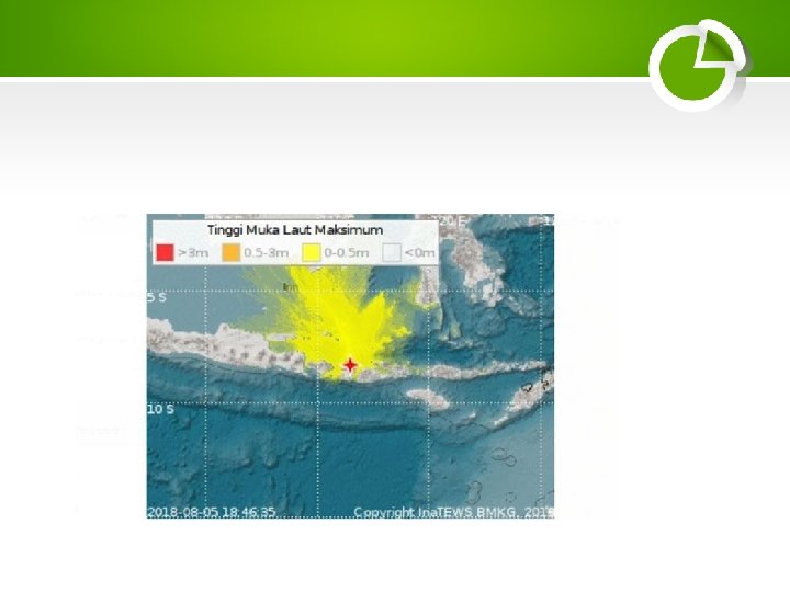
• TEMPO. CO, Jakarta - Badan Meteorologi Klimatologi dan Geofisika (BMKG) mencatat telah terjadi 814 kali gempa susulan setelah terjadinya gempa Lombok berkekuatan 7 SR pada Ahad, 5 Agustus 2018.
• • • PUBLISHED OCTOBER 2, 2017 Earthquakes are often thought of as largely unpredictable, wholly natural forces of nature—but that may be changing. A study published in the journal Seismological Research Letters this week identified 730 sites where human activity caused earthquakes over the past 150 years. And while we've long known that people can influence seismic activity, researchers were surprised to find that human activity has induced earthquakes with magnitudes as high as 7. 9—and that the number of earthquakes is clearly rising in some regions of the world. Just like earthquakes caused by nature, human-induced earthquakes have the potential to be dangerous, even deadly. And geologists are only just beginning to understand the repercussions these quakes could have on people and the environment.
FIJI EARTHQUAKE (photo via USGS)
• The powerful tremor struck off Ndoi Island, Fiji. However there is no tsunami threat from the earthquake because it was too deep. • The Pacific Tsunami Warning Center said some small, non-hazardous tsunami waves had been observed.
• Relate earthquake activity to plate tectonics Objectives • Define earthquake, and identify the focus and epicenter of an earthquake. • Describe the types of waves emitted during an earthquake. • Distinguish between earthquake intensity and magnitude. • Review some current methods of earthquake prediction.
Why do earthquakes occur? • Fractures, faults • Energy released and propagates in all directions as seismic waves causing earthquakes epicenter focus
do earthquakes occur: 1) Where Most earthquakes occur along the edge of the oceanic and continental plate 2) Along faults: normal, reverse, transform
definitions • Earthquake = Earthquake is a sudden & violent movement of the earth’s surface due to plate Tectonics, OR fracture within the earth followed by a series of shocks. • Seismic waves = Energy moving outward from the focus of an earthquake • Focus= location of initial slip on the fault; where the earthquake origins • Epicenter= spot on Earth’s surface directly above the focus
Seismic waves: forms • P-waves: – called compressional, or push-pull waves – Propagate parralel to the direction in which the wave is moving – Move through solids, liquids • S-waves: – Called shear waves – Propagate the movement perpendicular to the direction in which the wave is moving • Surface waves (L-waves or long waves). • • Complex motion Up-and-down and side-to-side Slowest Most damage to structures, buildings
Seismic waves: properties • Velocity: function of the physical properties of the rock the wave is traveling through – Velocity increases with rock density – Velocity changes when passing from one material to another (increases/decreases) – Liquids: S-waves do not get transmitted through liquid; P-waves slow down • Why is this important? –If we know the velocity of the wave, we can infer the type of rock it traveled through- that’s how we map the interior of the Earth!!!
Measuring earthquakes • Seismometers: instruments that detect seismic waves • Seismographs Record intensity, height and amplitude of seismic waves
Locating the shaking • Measure time between P and S waves on a seismogram • Need at least 3 seismographs
Earthquake size: two ways 1) to Magnitude: measure. Richter Scale • • Measures the energy released by fault movement related to the maximum amplitude of the S wave measured from the seismogram Logarithmic-scale; quantitative measure For each whole number there is a 31. 5 times increase in energy • eg. an increase from 5 to 7 on the Richter scale = an increase in energy of 992 times!!
2) Intensity: Mercalli Scale: • What did you feel? • Assigns an intensity or rating to measure an earthquake at a particular location (qualitative) • I (not felt) to XII (buildings nearly destroyed) • Measures the destructive effect • Intensity is a function of: • Energy released by fault • Geology of the location • Surface substrate: can magnify shock waves e. g. Mexico City (1985) and San Francisco (1989)
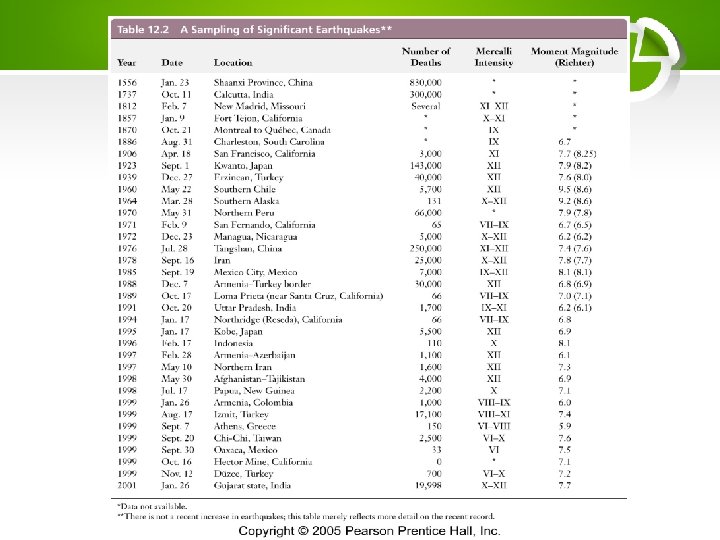
Frequency of Occurrence of Earthquakes Descriptor Magnitude Average Annually Great 8 and higher 1¹ Major 7 - 7. 9 17 ² Strong 6 - 6. 9 134 ² Moderate 5 - 5. 9 1319 ² Light 4 - 4. 9 13, 000 (estimated) Minor 3 - 3. 9 130, 000 (estimated) Very Minor 2 - 2. 9 1, 300, 000 (estimated) ¹ Based on observations since 1900. ² Based on observations since 1990.
Recent Earthquake Activity in the World
Largest earthquake in the world Chile : 1960 May 22 19: 11: 14 UTC Magnitude 9. 5 More than 2, 000 killed, 3, 000 injured, 2, 000 homeless, and $550 million damage in southern Chile tsunami caused 61 deaths $75 million damage in Hawaii; 138 deaths and $50 million damage in Japan; 32 dead and missing in the Philippines; and $500, 000 damage to the west coast of the United States.
Most Destructive Known Earthquakes on Record in the World Date Location Deaths Magnitude Comments May 31, 1970 Peru 66, 000 7. 9 $530, 000 damage, great rock slide, floods. July 27, 1976 China, Tangshan 255, 000 (official) 7. 5 Estimated death toll as high as 655, 000. Sept 19, 1985 Mexico Michoacan 9500 (official) 8. 0 Estimated death toll as high as 30, 000 Old lake bed magnified shock waves by 500% 2001 Jan 26 India 20, 023 7. 7 166, 836 injured, 600, 000 homeless. 2004 Dec 26 Sumatra 283, 106 9. 0 Deaths from earthquake and tsunami
Earthquake damage • Ground Failure - constructions collapse • Fires - from broken gas and electrical lines • Landslides - EQ's triggered; occur in hilly/mountainous areas. • Liquefaction - water-saturated, unconsolidated materials flow • Tsunami (seismic sea waves; "tidal" waves) - can grow up to 65 m
Short-term predictions Precursor phenomena (<1 year to days) 1. Foreshocks: usually increase in magnitude 2. Ground deformation 3. Fluctuations in water well levels 4. Changes in local radio wave characteristics 5. Anomalous animal behavior? ? ?
Impacts of Earthquake Prediction
Earthquake Terminology
What causes earthquakes? • Elastic Rebound • Sources of stress – Plate Tectonics – Other stresses
Measurement • Magnitude – one per earthquake – related to energy released – Richter or Moment scale • Intensity – many for each earthquake – measure of effects – Mercalli scale
Damage: Causes • • Ground motion Duration of Shaking Surface Rupture Poor building design
Effects • Rupture • Death • Bldg collapse
Effects • Fires • Liquifaction • Landslides
Damage: Key Factors • • Amount & duration of shaking Water content of soil Population concentration Building construction Distance from Epicenter Depth of focus Direction of rupture Material amplification
Addressing the Hazard • Identify areas at risk • Forecast
EARTHQUAKES • In what ways are earthquakes predictable? • To what other hazards are earthquakes linked? • What are the potentially disastrous consequences of earthquakes? • In what ways has human activity made earthquake hazards catastrophic? • How can the hazardous consequences of earthquakes be minimized?
EMERGENCY RESPONSE IN INDONESIA • Indonesian National Board for Disaster Management • The Indonesian Agency for Disaster Countermeasure (Indonesian: Badan Nasional Penanggulangan Bencana; officially National Disaster Management Authority), abbreviated as BNPB, is the Indonesian board for natural disaster affairs. It was established in 2008 to replace the National Disaster Management Coordinating Board (Badan Koordinasi Nasional Penanggulangan Bencana or Bakornas PB). BNPB is directly responsible to the President of Indonesia and the chairman is directly appointed by the President
• On 20 August 1945, the Indonesian government established the Agency for Assisting Families of War Victims (Badan Penolong Keluarga Korban Perang; abbreviated as BPKKP) and its focus was to assist the war victims f Indonesian National Revolution. • In 1966, the government established the Advisory Board of Central Natural Disaster
DUTY • Provide guidance and direction on disaster management effort that includes disaster prevention, emergency response, rehabilitation, and reconstruction in a fair and equitable • Assigning the standardization and implementation of disaster management needs based on laws and regulations • Delivering information to community disaster
FUNCTIONand establishment of disaster • Formulation management policies and handling of refugees to act quickly and appropriately and effectively and efficiently; and Coordinating implementation of disaster management activities in a planned, integrated, and comprehensive. [3] • issues regular information about the status of alerts for selected Indonesian volcanoes. In issuing these information bulletins, the Board draws on the advice of the Centre
FUNCTION • The alerts are also useful for visitors who may be planning trips to these sites. As of September 2011, five volcanoes were included on the Level III "Alert" (Indonesian: Siaga) list and 12 were on the Level II "Vigilant" (Indonesian: Waspada) list[4]
• LEVEL AKTIVITY (Kementerian ESDM. ) • 1. Aktif Normal (Level I) • Pada status ini, berdasarkan pengamatan dari hasil visual, kegempaan dan gejala vulkanik lainnya, kegiatan gunung api tersebut tidak memperlihatkan adanya kelainan. • 2. Waspada (Level II) • Terjadi peningkatan kegiatan gunung api berupa kelainan yang tampak secara
• 3. Siaga (Level III) • Berdasarkan hasil pengamatan visual, pemeriksaan kawah, kegempaan dan metode lain yang saling mendukung, peningkatan kegiatan gunung api tersebut semakin nyata. Berdasarkan analisis, perubahan kegiatan tersebut akan cenderung diikuti oleh letusan. • 4. Awas (Level IV)
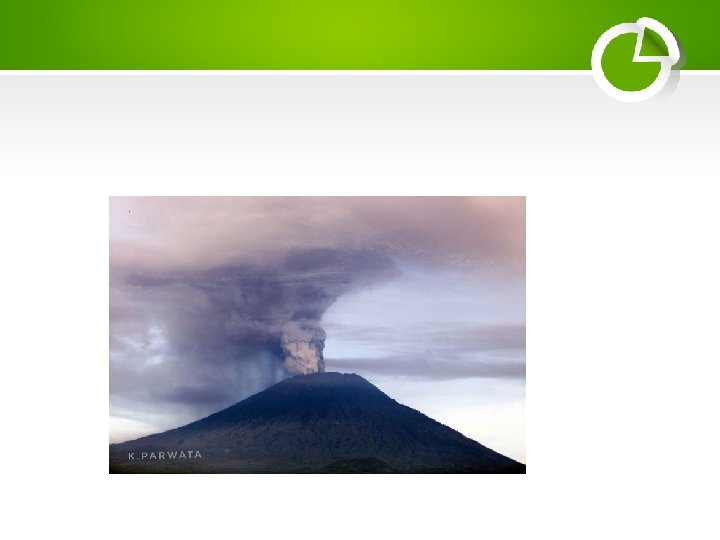
Figure 3. Seismic activity at Agung between 1 July and 13 September 2017. The Y-axis is the number of daily earthquakes. The increase in deep volcanic seismicity (VA, or Vulkanik Dalam) that began on 10 August 2017 was followed two weeks later by an increase in shallow volcanic seismicity (Vulkanik Dangkal or VB). Courtesy of PVMBG (Peningkatan Tingkat Aktivitas Gunung Agung, 14 September 2017)
Figure 5. A view into the summit crater of Agung on 20 October 2017, taken by a BNPB drone. Steam fumaroles rose from the NNE flank. N is to the left. Courtesy of PVMBG (Penurunan Status Gunungapi Agung, Bali Dari Level IV (awas) Ke Level III (siaga) Tanggal 29 Oktober 2017 Pukul 16. 00 WITA