Digimap Collections Introduction for site reps 29 March


")


 will be the contact point for the")
")


- Slides: 40
Digimap Collections Introduction for site reps 29 March 2017 Emma Diffley, EDINA Geosupport
Introduction for site reps • Digimap – – Overview What can I do with Digimap? Technical requirements Copyright • Administrative – Institutional Responsibilities – Support
Digimap Collections • 6 Digimap collections of mapping data • EDINA develops the service and hosts the map data • 5 Collections’ data licensed via Jisc Collections (Aerial is licensed directly via University of Edinburgh) • Institutions subscribe to each Digimap Collection separately • Users must register individually to gain access to any Digimap Collection
Subscriptions via Jisc Collections • Costs depend on Jisc banding scheme and collection – see Jisc Collections: http: //www. jisc-collections. ac. uk/Catalogue/ • Annual fee for each academic year, 1 August to 31 July – Fees revised annually by Jisc • Contact Jisc Collections helpdesk with subscription questions: – help. digitalresources@jisc. ac. uk – or 0203 006 6088. • For a free trial contact Jisc Collections: – help. digitalresources@jisc. ac. uk
Subscriptions to Aerial Digimap • Costs depend on Jisc banding scheme and collection – See Aerial Digimap Help pages: – http: //digimap. edina. ac. uk/webhelp/aerialdigimaphelp. htm#getting_started /subscribing. htm • Annual fee for each academic year, 1 August to 31 July – Fees revised annually • Contact EDINA helpdesk with subscription questions: – edina@ed. ac. uk – or 0131 650 3302 • No trials available for Aerial Digimap
Who provides the map data? Collection Data provider Agreement duration (annual opt out points) Digimap OS Ordnance Survey 2016 -2017 Historic Digimap Landmark 2016 -2019? Geology Digimap British Geological Survey 2016 -2017 Marine Digimap Sea. Zone 2016 -2019 Environment Digimap Centre for Ecology and Hydrology 2015 -2018 Aerial Digimap Getmapping plc 2016 -17
Technical requirements • Browser-based service • No installation requirements • Which browsers work? – Internet Explorer 11 and Edge – Latest versions of Firefox, Chrome and Safari • Mobile devices – Most functionality works with tablets – Use on mobile telephones less useful so lower priority for EDINA
Software guidance • Onward use of downloaded data will typically require: – GIS (geographic information system) – CAD (computer aided design) – Image processing software • Suitable software licences available through eduserv CHEST (e. g. Arc. GIS) or freeware (e. g. QGIS) • Local support will be required for these packages – this is not necessarily the site rep’s responsibility • Some information about software given in Digimap Help pages – not exhaustive – provides guidance on most widely used software
Licences • On subscribing, a sub-licence between Jisc Collections/Uo. E and your institution comes into effect • Each Digimap Collection has a separate licence • Users must accept the licence terms for a collection before they can use it • Digimap Ordnance Survey Collection and Environment Digimap differ in structure: – Institutional sub-licence – Additional EULA (End User Licence Agreement) between end user and Ordnance Survey or CEH • All licences available in full here: – http: //digimap. edina. ac. uk/webhelp/digimapsupport/access/lic ence_agreements. htm
Summary of terms of use • Maps produced from Digimap are for: – Teaching, Educational Research or Academic Research by registered users. – Limited Administrative use e. g. provide a campus map in a prospectus • Users can…. . (not an exhaustive list!): – – – print maps publish maps on paper and the web (exceptions for social media) publish maps in journals share data with other Authorised Users download and store map data on any device display, view, interrogate, manipulate, modify and search the map data • Further information in our Copyright & Licensing Webinar – WE WOULD STRONGLY RECOMMEND YOU ATTEND/WATCH THIS
Licensed vs Open Data • Some Collections have both Licensed Data and Open Data • Licensed Data is only for use for Educational Purposes and is covered by the Digimap licences • Open Data is covered by separate Open Licences: – OS data operates under the Open Government Licence – BGS data operates under the BGS Open. Geoscience Licence • Open Data products are also available from other websites – Commercial use permitted – Some other websites may charge, especially for “value added” versions • There is no overlap. Data are either covered by the Digimap licence or the open licence
How do I know if it’s Licensed Data or Open Data? • Roam service: – Information is available in the Map Information panel. • Data Download service: – Find out in Product Information boxes. – Click on Info next to product name in Select Data panel. – Text file sent with each download detailing which licence covers each data product.
Poll User queries – what Digimap questions do you receive? Tick all that apply. • • • Login/registration Using Roam or Data Download Copyright Using data in GIS/CAD I don’t receive any queries
Institutional Responsibilities Where are these specified? Collection Section of Licence Agreement Ordnance Survey Section 7 + Appendix 3 Marine Digimap Section 5 + Appendix 3 Geology Digimap Section 5 Historic Digimap Section 5 Environment Digimap No specific section Aerial Digimap Section 5
Responsibilities Institutions must: • Ensure there is no unauthorised access to the Digimap service – Institutional systems must be in place to grant/deny access according to a user’s status with the institution • • Ensure there is no unauthorised access to the Licensed Data Nominate local support staff Communicate any actual or possible licence breaches to EDINA In the event of licence breaches, investigate and liaise with EDINA to implement any disciplinary procedures
How do users get access? Overview: • Login via UK Federation • Institutions must be able to assert User Accountability, i. e. trace any usage of the service back to an individual – Eduserv can help with this if you are outsourcing your Id. P • Institutional Identity Providers (Id. P) must release appropriate attributes: • Check UK Federation Metadata • http: //www. ukfederation. org. uk/content/Services/2008 -01 -04 -digimap • EDINA does not issue passwords or accounts • EDINA has no control over the set-up of your local authentication system. You must seek advice from the UK Federation Helpdesk, or Eduserv if you are using Open. Athens
Who can use Digimap? • Anyone who qualifies as an Authorised User • Definitions given in each Licence Agreement – vary slightly between agreements
OS definition of Authorised User • Authorised User – an individual who: – is authorised by an institution to have access to its information services via Secure Authentication – has completed EDINA’s registration process for the Digimap service and has accepted the terms of the licence AND is: • a current student, • member of staff (whether permanent, temporary or retired) • consultant or contractor of the Institution who is employed for purposes of teaching or undertaking research
Qualification to OS definition • Users do not qualify as Authorised Users for the duration of extended periods abroad (extended period is more than one academic term) • Students and staff members registered at an overseas campus DO qualify as Authorised Users (as of Aug 2016) • Consultants or contractors only qualify for the period necessary to fulfil the teaching or research for which they were engaged • Distance learners also qualify as Authorised Users even if they are overseas
User registration • • • Individual registration required Instant access granted User email must be correct and must be one in use Change of user details submitted via My. Digimap area, at top right of Digimap Collections page After registering, users must accept the terms of each licence agreement before they can use any collection
Frequently Asked Questions • How do users get access? – Login using local authentication credentials, register, accept terms of licences • Does everyone have to register? – Yes • Can we have direct access via IP? – No • Why are some users being asked to register again? – Registrations expire if they are not used for 12 months • How can I ensure that unauthorised individuals do not access Digimap? – Talk to your IT staff – Different groups of users have different attributes to their login credentials which either permit or deny access – Some institutions do not regard retired staff as full “members”, others do; both will be able to assign appropriate access privileges.
Local Support staff On subscription: • EDINA will ask you to nominate local support staff – – Confirmation of main site rep Additional site reps (optional) Responsible Officer for Data Security and Deputy (mandatory) One person can undertake multiple roles • EDINA will add the contact details to a Digimap help page: http: //digimap. edina. ac. uk/webhelp/digimapsupport/service_info/site_re p_list. htm • As a site rep you will receive email from EDINA regarding events, service issues and individual users (if queries arise)
Site Representative role • The Site Representative(s) will be the contact point for the Digimap Service within the Authorised Institution • They will also be responsible for general promotion of the service and support for the service relating to local infrastructure and procedures • It may be convenient for some Authorised Institutions to have more than one representative, particularly where the Authorised Institution is located across more than one site • Maximum number of Site Representatives is not expected to exceed 5
Responsible Officer for Data Security • The Responsible Officer for Data Security (and Deputy) will take responsibility for ensuring the observance of the conditions for use of the Licensed Data under the terms of this Sub Licence Agreement by all Authorised Users of their Authorised Institution • They have a duty to report to EDINA any suspected security weaknesses of the Digimap service and to advise EDINA immediately of any actual incidences of misuse of the Licensed Data. • The Responsible Officer for Data Security (and Deputy) also has a duty to ensure that action plans for resolution of incidents are implemented fully and to the satisfaction of Jisc Collections and Ordnance Survey • High level role, concerned with appropriate implementation of institutional systems • Not responsible for individual users use of Licensed Data
Licence breaches • Incidents categorised as of two types: – User-related incident, e. g. a single user sharing their password with friends or sharing data they’ve downloaded with others who are not Authorised Users – Institutional-related incident, e. g. a systematic failure of the institution to terminate access once individuals cease to be members of the institution (e. g. terminating graduate accounts) • Procedures detail: – how EDINA will record any reported incidents and report them to Jisc Collections and the data owners – timescales for resolution – when access would be suspended for an individual or institution, if satisfactory resolution not achieved
EDINA Helpdesk • Lots of knowledge • Don’t hesitate to contact with any questions • Aim to respond to all user queries within 24 hours (except at weekends) • Contact details: – email: edina@ed. ac. uk – telephone: 0131 650 3302
Chat facility • Open to any user • On all Digimap help pages • Available in office hours
Digimap Resource Centre http: //digimap. edina. ac. uk/webhelp/resour ces/index. html • Access to all help pages • Links to lots of resources
Digimap Resource Centre • • All help pages Case studies You. Tube PDF Guides Powerpoints Training materials GIS/CAD help FAQs
General Digimap Support area Useful reading for those new to Digimap: • Access information, including subscription and login help • Summary of collections • Terms of service • Case studies
Digimap support email list • All site representatives are added to a servicespecific mailing list for all EDINA site representatives • Allows EDINA to communicate service information to site reps • All lists are moderated to prevent spam
Usage statistics • EDINA emails login numbers to site reps every month • More detailed usage statistics available through a Site Rep Service area. Request access from EDINA helpdesk if you don’t have it • Please contact us with any queries about usage statistics
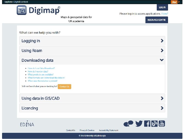
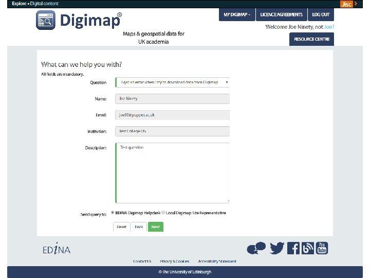
New “Contact Us” System • Contact Us system currently under development • Aims towards self-help rather than waiting for an answer from a human • Site reps will receive some enquiries from this form • Under development: feedback welcome
Social media http: //digimap. blogs. edina. ac. uk/ https: //www. facebook. com/EDINADigimap https: //twitter. com/EDINA_Digimap https: //www. youtube. com/user/EDINADigimap We use our social media to: • alert users to significant downtime periods or unexpected outages • announce updates to the services • offer free training • promote new help and support resources • signpost users to other relevant and interesting information
Training • Training courses: – We provide introductory training for institution staff on Digimap – We are not funded to provide GIS training – Fewer courses in 2016 -17. Concentrating on webinars • Regular webinars: – Schedule at: http: //edina. ac. uk/events/ – Usually 30 mins to 1 hour long, depending on topic – Open to all users – We regularly send details of forthcoming webinars to all Digimap users • Training materials: – See the Learning & Teaching Zone of the Digimap Resource Centre
Site Reps Guidance document • Document with introductory guidance for Site Reps • Signposts to more detailed information • Feedback is very welcome • http: //digimap. edina. ac. uk/w ebhelp/digimapsupport/abou t. htm#site_rep_information/s ite_rep_guidance. htm
Setup local support web pages • Send us a link to any Digimap support page for your users • We will ensure your users see them under Local Support Information
Your questions